
Water Table Contour PowerPoint PPT Presentations
All Time
Recommended

Coordination of Indiana GIS through dissemination of data and data ... EDNA - Elevation Derivatives for National Applications. NHDPlus ... http://edna.usgs.gov ...
| PowerPoint PPT presentation | free to view

Lecture 34 Leaching requirements - irrigation and drainage water quality recycling of drainage water for irrigation Extensive areas of land in the arid and semi arid ...
| PowerPoint PPT presentation | free to download

FRESH WATER AND SALTED WATER IN PANNONIAN DEPOSITS FROM ... Emil RADU, Catalina RADU. National Institute of Hydrology and Water Management, Bucharest, Romania ...
| PowerPoint PPT presentation | free to view

JCSA Grinder Pump Program Why a grinder pump? Simply put, wastewater won t go where you need it to, or there is no public sewer available. Grinder pumps are ...
| PowerPoint PPT presentation | free to download

Department of Geology and Geophysics, University of Calgary. Supervised by Dr. Cathy Ryan ... AENV water well database (geology and water table contour map) ...
| PowerPoint PPT presentation | free to view

Introduction, of Ground water hydrology analysis and formation
| PowerPoint PPT presentation | free to download
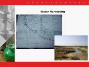
Water Harvesting Water harvesting measures These are artificial recharge measures that capture rainfall and run-off and store it in the soil profile or add to the ...
| PowerPoint PPT presentation | free to download

Got Water? Developed by: Hud Minshew, Oregon State University Extension Service Susan Donaldson, University of Nevada Cooperative Extension UNCE, Reno, Nev.
| PowerPoint PPT presentation | free to download

Concept used in ancient mountainside farming systems in Asia and South America. ... Bench Terraces in Japan. ASAE S268.4. 26. Bench Terraces in the US. ASAE S268.4. 27 ...
| PowerPoint PPT presentation | free to view

California Water Issues AGST 3000 Agriculture, Society and the Natural World Whiskey s for drinkin and water s for fighting for . Mark Twain
| PowerPoint PPT presentation | free to view

What are the water requirements for plants? plants use several hundred pounds of water for each pound of ... grassland farming. Irrigation: may not be practical ...
| PowerPoint PPT presentation | free to view

There are 69,155,856 pounds of nitrogen in the air above an acre. ... a thin layer of water etc., the farther away from the soil particle you get, the ...
| PowerPoint PPT presentation | free to view

GIS in Water Resources Review for Midterm Exam Data Models A geographic data model is a structure for organizing geospatial data so that it can be easily stored and ...
| PowerPoint PPT presentation | free to view

STORM WATER PERMITS. AND. HYDROSTATIC TEST WATER DISPOSAL. HANK STONEROOK, P.E. ... Provide information about hydrostatic test water disposal ...
| PowerPoint PPT presentation | free to view

Wyoming Water Forum
| PowerPoint PPT presentation | free to view

(Tons/Acre/Year) Forest Land: 1 to 5. Farm Land: 10 to 40. Construction ... Texture or Particle Size Distribution. Silt is the most easily eroded component. ...
| PowerPoint PPT presentation | free to view

GHSGT PREP Table of Content Tab 1: World Studies Tab 2: U.S. History to 1877 Tab 3: U.S. History since 1877 Tab 4: Civic/Citizenship Tab 5: Map and Globe Skills
| PowerPoint PPT presentation | free to view

GHSGT PREP Table of Content Tab 1: World Studies Tab 2: U.S. History to 1877 Tab 3: U.S. History since 1877 Tab 4: Civic/Citizenship Tab 5: Map and Globe Skills
| PowerPoint PPT presentation | free to view

One should know the effects that your water quality & irrigation practices used have on: ... 1. Tensiometer measures in atmosphere ...
| PowerPoint PPT presentation | free to view

'aims to increase the productivity and efficiency of Australia's water ... Stand density blue gums WA. Cumulative evapotranspiration (mm) White et al, unpubl. ...
| PowerPoint PPT presentation | free to view

... this is spring) - Glimpses of Redeemed Creation Creation, Fall, ... a society of possible gods and ... fall into three categories: Nature, God, Man s ...
| PowerPoint PPT presentation | free to view

Understand how soil properties ... Instrument Selection ... against gravity by surface tension Soil water/ soil moisture Zone of Saturation pores filled ...
| PowerPoint PPT presentation | free to view

Water Supply Sector Overview
| PowerPoint PPT presentation | free to view

Demand Modelling in Indian Planning is done by preparing income and price elasticities. ... area and its allocation, the conti nuance of past patterns is postulated in ...
| PowerPoint PPT presentation | free to view

GHSGT PREP Table of Content Tab 1: World Studies .. Tab 2: U.S. History to 1865 . Tab 3: U.S. History since 1865
| PowerPoint PPT presentation | free to view

Title: No Slide Title Author: lpm Last modified by: PPSUB Created Date: 6/30/2002 7:34:48 PM Document presentation format: A4 Paper (210x297 mm) Other titles
| PowerPoint PPT presentation | free to view

The whole thing that changes the diaper happens pretty instantly — so you’ll have to be ready from the get go. You can keep using a changing table until your child reaches a height of 32 inches — the standard length of a changing pad — which is likely to occur around their first birthday. We asked thousands of real families about the baby products they support the most, then we took the table and pads that they shared with us and added our own research and insight. We think that at least one of these things would love you and your little one as well.
| PowerPoint PPT presentation | free to download

A geographic data model is a structure for organizing geospatial data so that it ... Catchments are a tessellation of the landscape through a set of physical rules ...
| PowerPoint PPT presentation | free to download

Measurement station (spatial) National Hydro Data Programs. National ... Tracking Analyst Display. DEM Based Watershed and Stream Network Delineation Steps ...
| PowerPoint PPT presentation | free to download

WATER SAVING TECHNOLOGIES WITH REGARD TO SUPPLY. Improvement of conveyance and distribution systems ... water losses, the conveyance and distribution of ...
| PowerPoint PPT presentation | free to view

Texas data and water modeling: Hudgens, Mason, Davis Jonsdottir, ... (convolve in time and space) Mary Lear. Flow Direction Data from Fine. to Coarse Resolution ...
| PowerPoint PPT presentation | free to download

GIS in Water Resources Midterm Review David Maidment, David Tarboton and Ayse Irmak ...
| PowerPoint PPT presentation | free to download

Keith Buttleman, Assistant General Manager. Lanya Ross, Senior ... Investment in transportation, wastewater, parks. Perceived groundwater resource limitations ...
| PowerPoint PPT presentation | free to view

Death Valley 282 feet. Dead Sea 1309 feet. Mariana Trench 36,000 feet. Positive Elevation ... rift African Rift Valley. sea floor spreading Mid-Atlantic Ridge ...
| PowerPoint PPT presentation | free to view

WFM 6202: Remote Sensing and GIS in Water Management [Part-B: Geographic Information System (GIS)] Lecture-8: Spatial Analysis Akm Saiful Islam Institute of Water and ...
| PowerPoint PPT presentation | free to view

Overlay: Overlaying of more than two layers, including rebuilding topology of ... Overlay of vector data results in the creation of new line and area objects with ...
| PowerPoint PPT presentation | free to view

... deflected to the right in the Northern Hemisphere and the to left in ... Dust particulates, sea salt, sulfur and nitrogen oxide aerosols serve as common ...
| PowerPoint PPT presentation | free to download

... Bulgaria, scale 1:50000 and map sheets of the Yantra river watershed activated ' ... Yantra. river. watershed 'GeoWateRIAS ' ...
| PowerPoint PPT presentation | free to view

Current water levels in Lake Victoria are below normal and the lowest level ... Population growth around Lake Victoria, the continent's largest lake, is ...
| PowerPoint PPT presentation | free to view
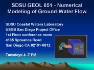
SDSU Coastal Waters Laboratory USGS San Diego Project Office 1st Floor conference room 4165 Spruance Road San Diego CA 92101-0812 Tuesdays 4 -7 PM
| PowerPoint PPT presentation | free to download

WFM 6202: Remote Sensing and GIS in Water Management Dr. Akm Saiful Islam ... because boundaries tend to have a blocky appearance rather than the smooth lines ...
| PowerPoint PPT presentation | free to view

What I learned using GIS for Water Basin Analysis ... the same issues on color, symbology, labeling apply as with static presentations, ...
| PowerPoint PPT presentation | free to view

... digital format is most expensive (about 80 ... and procedures are time consuming in GIS, the data sources for data acquisitions ... Ground survey with GPS ...
| PowerPoint PPT presentation | free to view

evaluation and development of ground water resources of ada'a becho plains for irrigation project engida za*, tilahun a*, dr. seifu k* and dr. yilma*
| PowerPoint PPT presentation | free to view

WFM 6202: Remote Sensing and GIS in Water Management [Part-B: Geographic Information System (GIS)] Lecture-2: Data Model and Structure Dr. Akm Saiful Islam
| PowerPoint PPT presentation | free to view

Water Transit times and flowpaths in a microcatchment from two line ... traversing a one meter wide swathe of soil under saturated flow conditions, as ...
| PowerPoint PPT presentation | free to view

Select Categories from Symbology tab. District name as Value Field. Click on Add All values ... Change symbology of district maps to zstat.MEAN. Turn on Label ...
| PowerPoint PPT presentation | free to view

Class A Evaporation pan. Source: American Meteorological Society ... a velocity (e.g. meters per day) and is the rate of flow per unit area through a ...
| PowerPoint PPT presentation | free to view

Title: PowerPoint Presentation Last modified by: Idli Created Date: 1/1/1601 12:00:00 AM Document presentation format: Other titles: Arial Times ...
| PowerPoint PPT presentation | free to download

Pumping test data and water table elevations. ... several touristic villages newly developed along the northwestern coast, west of ...
| PowerPoint PPT presentation | free to view
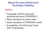
Raster calculation of wetness index. Raster calculation of TOPMODEL runoff ... Relative wetness at a point and depth to water table is determined by comparing ...
| PowerPoint PPT presentation | free to download

... and fissures in the limestone bedrock below the water table (phreatic zone) ... directly from the surface soils, regolith and epikarst into the phreatic zone. ...
| PowerPoint PPT presentation | free to view

... between a water tower and one of these road intersections is 0.25 inches, how ... Contour maps through stereoscopic plotting, Orthophotos and digital orthophotos, ...
| PowerPoint PPT presentation | free to view

Mantri Lithos is a spectacle set in stone. An abode so unique in design and formation ths it's a milestone among all other residential spaces in the city. Crafted with a patische of eccentric shapes, rebellious structures and maverick contours, here's a residential address set out of eternity. Founded with structural contemplations that defy conventional living spaces, our creation is an antithesis to every known architecture. Mantri Lithos isn't just for everyone. It's for those who indulge in a life of adventure. Mantri Manyata Lithos design has been inspired by Natural Rock formations. It has a complete natural feel to it with Green building features, lavish and landscaped garden, cool water bodies and a swimming pool along with toddler’s pool and Jacuzzi pool. It is spread in 10 acres of land with a horde of community amenities being available for residents.
| PowerPoint PPT presentation | free to download

Custom logo printed tablecloths, table runners, fitted table covers, table skirts, and banners are a great way to brand your company at your next show, display, sale or special event. https://premiertablelinens.com/collections/custom-printed-linens
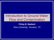
Introduction to Ground Water Flow and Contamination
| PowerPoint PPT presentation | free to download