
Seasat PowerPoint PPT Presentations
All Time
Recommended

Lessons Learned . . . And Not Learned Rick Obenschain Acting Director of Flight Programs and Projects NASA Goddard Space Flight Center Rick Obenschain
| PowerPoint PPT presentation | free to download

Images received locally are from AVHRR (thermal, visible: ... Altimeter: Skylab, Geos 3, Seasat, Geosat, ERS, Topex/Poseidon, Jason, Envisat, ... RADAR ALTIMETER ...
| PowerPoint PPT presentation | free to view

Ocean Exploration and Sea Floor Characteristics 8th Grade Earth Science Ocean Exploration Ships People have used the oceans since ancient times.
| PowerPoint PPT presentation | free to download

Ocean Floor Exploration HMS Challenger (1872-1876) SONAR (Echo Sounder) Satellites In the 1970s, orbiting satellites began to collect ocean data This method proved to ...
| PowerPoint PPT presentation | free to view

Features of the Ocean Floor Essential Question What does the Ocean Floor Look Like Sketch a picture of your hypothesis. Features of the Ocean Floor Continental shelf ...
| PowerPoint PPT presentation | free to view

Files of elevation data with each pixel assigned a height value. What is a DEM (Digital Elevation Model)? What the numbers mean when converted to a DEM ...
| PowerPoint PPT presentation | free to view

President Eisenhower (1 October 1958) established the National ... 1969 : started my teaching job in Oceanography and conducting wave research for NASA. ...
| PowerPoint PPT presentation | free to view

InSAR Methods and Applications
| PowerPoint PPT presentation | free to download
History of Oceanography Why study historic oceanography? Connected to the world s overall history Commerce, warfare, resources, weather The oceans have shaped ...
| PowerPoint PPT presentation | free to download
Ocean exchanges with the atmosphere .did we learn anything during WOCE? Peter K. Taylor Southampton Oceanography Centre UK
| PowerPoint PPT presentation | free to download

A non-rotating Earth would have only two cells. Coriolis effects deflect to the right of the direction of ... 1 Dobson Unit = 2.69X10¹⁶ molecules Ozone cm-2 ...
| PowerPoint PPT presentation | free to view
In This presentation Tells that the Different type of sensors used in the Satellites.What are uses of sensors,and how it capture the images.Some of satellites with what type of sensors they attached to it is also noted.what are the uses of sensors,Payload ,types of camera are explained in this presentation.
| PowerPoint PPT presentation | free to download

Geodesy in the 21st century Shimon Wdowinski University of Miami Susan Eriksson UNAVCO Related but .. Big Idea #2: Earth is 4.6 billion years old. 2.7 Over Earth ...
| PowerPoint PPT presentation | free to view

geoid. MSSH. dyn. topog. oceanography. by taking advantage of. signal ... geoid = MSSH - dyn topo. blue error spectrum. Joint solution of. GSTM / SPP 1257 ...
| PowerPoint PPT presentation | free to view


Geostrophic Balance. If: Only important forces are Pressure ... Geostrophic Currents. In x-dir: fv = 1 dp. Assuming the current is uniform ... Geostrophic ...
| PowerPoint PPT presentation | free to view

Data for Plate Tectonics. Earthquakes. World wide network for detecting nuclear tests ... Mapping ocean floor key to understanding Sea Floor Spreading ...
| PowerPoint PPT presentation | free to view
Exploring the Deep .... Today's Tune 'Pirates of the Caribbean' Registration Problems? Please see... Beneath the ocean's surface lie hidden mountain ranges, ...
| PowerPoint PPT presentation | free to download

ratio of incident to reflected flux. range 0 to 1. Basic Assumption of RS ... can highlight terrigenous material (via clay & iron oxide) Introduction to Remote Sensing ...
| PowerPoint PPT presentation | free to view
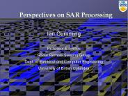
Perspectives on SAR Processing
| PowerPoint PPT presentation | free to download

ODINAFRICA/GLOSS Sea Level Training Course TIDE GAUGES AND ALTIMETRY IN THE GULF OF GUINEA 13-24 November 2006, Oostende Angora AMAN Contents The system - Principles ...
| PowerPoint PPT presentation | free to download
Remote Sensing and Image Interpretation. 4thed., John Wiley and Sons, Inc., New York. NEAR INFRA RED and Thermal Radiation Dr. M. M. Yagoub Dep. Of ...
| PowerPoint PPT presentation | free to download

In the resort town of Skagen you can watch an amazing natural phenomenon. ... Oceans and Sunlight Sunlight will barely reach 150-m deep into the ocean.
| PowerPoint PPT presentation | free to download

Uses microwave (cm to meter scale) wavelengths. Atmosphere very transparent ... Reflection either diffuse or specular. Backscatter dependent on incidence angle ...
| PowerPoint PPT presentation | free to view

Microwave Remote Sensing: Principles and Applications
| PowerPoint PPT presentation | free to download
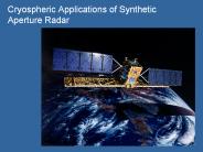
Cryospheric Applications of Synthetic Aperture Radar
| PowerPoint PPT presentation | free to download

HISTORY OF OCEANOGRAPHY EARLY EXPLORERS TRADE ROUTES Egyptians(4,000BC): first to build ships, used for trade Polynesians(2,000-500 BC)-voyaged across the Pacific ...
| PowerPoint PPT presentation | free to view

This shows us information that we could not see in the air photo. Air photo ... Digital Elevation Model of Downtown Cleveland. WHY USE DIGITAL ELEVATION MODELS? ...
| PowerPoint PPT presentation | free to view

Aucun titre de diapositive
| PowerPoint PPT presentation | free to download

Title: Interferometric Synthetic-Aperture Radar (InSAR) Basics Author: CReSIS Last modified by: CReSIS Created Date: 9/8/2006 3:46:30 PM Document presentation format
| PowerPoint PPT presentation | free to view
History of Marine Science Unit 2
| PowerPoint PPT presentation | free to download

SAR Application Policy Study : Analysis of SAR-Related Journal Papers Hoonyol Lee Department of Geophysics Kangwon National University Email: hoonyol@kangwon.ac.kr
| PowerPoint PPT presentation | free to download

Geomatics is the science and technology ... Geomatics encompasses a broad range of disciplines that can be brought together ... Geodetic Survey. Remote Sensing ...
| PowerPoint PPT presentation | free to view

500 B.C. Greeks record travels along the northwestern coast of Africa. 450 B.C. Herodotus compiles a map of the known world ...
| PowerPoint PPT presentation | free to view

Chapter 13 Exploring the Oceans Preview Section 1 Earth s Oceans Section 2 The Ocean Floor Section 3 Life in the Ocean Section 4 Resources from the Ocean
| PowerPoint PPT presentation | free to download

History of Oceanography SCRIPPS Woods Hole Lamont The expansion of oceanography German U-boat led to the invention of the echo sounder to detect submarines WW2 ...
| PowerPoint PPT presentation | free to view

ReEnvisioning the Ocean: The View from Space
| PowerPoint PPT presentation | free to view

History of Marine Science Lecture 2 Ponce de Leon found the gulf stream by accident en-route to Cuba. John Harrison In 1760, he solved the problem of calculating ...
| PowerPoint PPT presentation | free to view

Coastal Zone Color Scanner CZCS
| PowerPoint PPT presentation | free to view

Airborne platforms can include kites, balloons, model aircraft, microlights, ... is generated by the device and bounced back off the surface and recorded by the device ...
| PowerPoint PPT presentation | free to view
Active Microwave Remote Sensing ... a receiver, one or more antennas, GPS, computers Microwaves Band Designations (common wavelengths Wavelength ...
| PowerPoint PPT presentation | free to download

EM wavelength (defines radiometer operating frequency) EM polarization ... SSM/I is a seven channel passive microwave radiometer operating at four frequencies ...
| PowerPoint PPT presentation | free to view
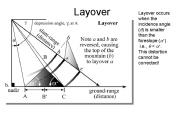
Layover Layover occurs when the incidence angle (q) is smaller than the foreslope (a+) i.e., q
| PowerPoint PPT presentation | free to download

Title: Interferometric Synthetic-Aperture Radar (InSAR) and Applications Author: CReSIS Last modified by: CReSIS Created Date: 9/8/2006 3:46:30 PM
| PowerPoint PPT presentation | free to view

In this lecture the group of satellites in white text are ... Advanced Visible and Near Infrared Radiometer (AVNIR) Ocean Color and Temperature Sensor (OCTS) ...
| PowerPoint PPT presentation | free to view

What's it like on a ship? 1998 L'Atalante cruise. What? ... satellite altimetry against 'ground-truthed' shipboard bathymetry measurements. ...
| PowerPoint PPT presentation | free to view

Most scientists prior to the 1900's thought the ocean floor ... Surface Temperature Changes Surface-zone temperatures vary with latitude and the time of year. ...
| PowerPoint PPT presentation | free to download

History of Marine Science Unit 2 * * * * * * * Voyaging Travelling for a specific purpose First navigation was by celestial navigation- finding one s position in ...
| PowerPoint PPT presentation | free to view

Adaptive Optics: basic concepts, principles and applications Short course of lectures Vadim Parfenov Res.Ctr. S.I.Vavilov State Optical Institute
| PowerPoint PPT presentation | free to download

G omatique pour les enseignants et les enseignantes. Qu'est-ce que la G omatique ? ... Tr s loin de la cible, partir de ce qu'on appelle une plate-forme. ...
| PowerPoint PPT presentation | free to view
Azimuth (or along-track) Resolution ... Great improvement in azimuth resolution could be realized if a longer antenna were used. ...
| PowerPoint PPT presentation | free to download

The acquisition of information about a target in the absence of physical contact ... Geometric optics (r l), 'specular' Rayleigh scattering (r l) intensity ...
| PowerPoint PPT presentation | free to view

Department of Geomatics. Remote Sensing, Principles and Applications. SATELLITE IMAGING SYSTEMS ... Radar altimeter. Measures wave height. Department of Geomatics ...
| PowerPoint PPT presentation | free to view
NIR is within the reflective portion of the spectrum and can be ... Lithology & geology. Urban land use. Natural disaster monitoring (volcano) Thermal pollution ...
| PowerPoint PPT presentation | free to download

Neotectonics - upper crustal response to plate margin processes ... A record (relict fragments) of plate(s) of the Pacific that are interacting with ...
| PowerPoint PPT presentation | free to view

Cousteau traveled the world's oceans in his research vessel
| PowerPoint PPT presentation | free to view