Layover - PowerPoint PPT Presentation
1 / 29
Title:
Layover
Description:
Layover Layover occurs when the incidence angle (q) is smaller than the foreslope (a+) i.e., q – PowerPoint PPT presentation
Number of Views:72
Avg rating:3.0/5.0
Title: Layover
1
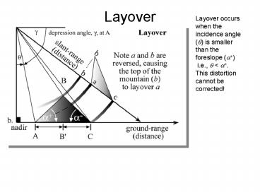
Layover
Layover occurs when the incidence angle (q) is
smaller than the foreslope (a) i.e., q lt a.
This distortion cannot be corrected!
2
(No Transcript)
3
Radar Shadowing
Radar shadowing can be useful for interpreting
geomorphological features
4
(No Transcript)
5
Radar Backscatter
6
Radar Backscatter Coefficient
- The efficiency the terrain to reflect the radar
pulse is termed the radar cross-section, ? - The radar cross-section per unit area, (A) is
called the radar backscatter coefficient (?)
and is computed as - The radar backscatter coefficient determines the
percentage of electro- magnetic energy reflected
back to the radar from within a radar pixel - This is similar to the reflectance in optical
remote sensing
7
Radar Backscattering
8
Radar Backscattering
- Depends on the properties of the target
- roughness
- dielectric constant
- Depends on characteristics of the radar
- depression angle
- frequency/wavelength
- polarization
9
- Electrical (E) and magnetic field (B) are
orthogonal to each other - Direction of each field is perpendicular to the
direction of wave propagation.
10
Polarization
11
Polarization
- Plane polarized light can be either
- vertically polarized (E0 is perpendicular to the
plane of incidence) - horizontally polarized (E0 is parallel to the
plane of incidence) - Solar radiation is unpolarized (random) but can
become polarized by reflection, scattering, etc. - Lasers and radars produce polarized radiation
12
Radar Polarization
- Cinder cone and basalt lava flow in north-central
Arizona. - Strong return in the HH polarized image and weak
HV polarization indicates that the lava is not
depolarizing the radar pulse (it is composed of
large blocks with smooth faces)
13
Rayleigh Criterion for Roughness
- A surface is considered smooth at or below a
height, h, if -
cm - h the vertical relief (average height of
surface irregularities) - l the radar wavelength (measured in cm)
- g the depression angle
14
Nile River Sudan
Space Shuttle Color-Infrared Photograph
SIR-C Color Composite Red C-band HV
Green L-band HV Blue L-band HH
C-band, ?? 6cm L-band, ?? 24cm
15
Radar and the Dielectric Constant
- Dielectric constant depends on the type of
material as well as its moisture state - it is analogous to the refractive index of the
material - it is primarily a function of moisture content
- also depends on chemical properties such as
salinity - Dielectric constant is the ratio of the
capacitance of a material to that of a vacuum.
Also known as the relative permittivity
16
Dielectric Constant
dielectric constant of liquid water is 80 dry
soil is 2-4.
17
Radar frequency and backscatter
- Depth of radar penetration through the vegetation
canopy varies directly with l
18
Types of Active Microwave Surface and Volume
Scattering that Take Place in a Hypothetical Pine
Forest Stand
19
Response of A Pine Forest Stand to X-, C- and
L-band Microwave Energy
20
SIR-C/X-SAR Images of a Portion of Rondonia,
Brazil, Obtained on April 10, 1994
21
Interferometric Synthetic Aperture Radar InSAR
RADAR records both the backscattered intensity as
well as the phase of the wave when it interacted
with the terrain
22
constructive interference
- Waves of microwave energy can have constructive
interference or destructive interference
depending on how they match up
destructive interference
23
With SAR interferometry, radar images of the same
area are acquired at two different times
(multiple pass) or from two side-by-side
synthetic aperture radars (single pass) The
interference pattern between the two phase images
gives information on height and
displacement Its analogous to
stereo-photogrammetry except that it uses the
phase information
24
Geometric Relationship Between Two SAR Systems
Used for Interferometry to Extract Topographic
Information
25
Range differences produce meter-scale accuracy
but phase differences produce millimeter-scale
accuracy The phase shift between the two images
corresponds to relative difference in range
between the two radars
26
Shuttle Radar Topography Mission (SRTM)
- Used C and X-band interferometry to produce the
first near-global topographic map of the Earth.
February 2000 (10-day mission) - Space Shuttle Endeavor 2 radar antennas, 60 m
apart - Covered 80 of Earths surface (60o N to 54o S)
27
InSAR and velocity
- If you have exact repeat overpass then you can
use phase shifts from one time to another to
indicate ground movement - This has been used to map glacier velocities,
movement along faults, volcanic uplift
28
Lambert Glacier, Antarctica
Interferometric Synthetic Aperture Radar
(InSAR) uses phase difference between two images
to determine glacier speed and direction
Image courtesy CSA, NASA, Ohio State Univ., JPL,
ASF
29
Radar Sensors
- Geosat
- Seasat
- Shuttle Imaging Radar (SIR-A, SIR-B, SIR-C)
- ERS-1, ERS-2
- JERS-1
- Radarsat
- JPL AirSAR
- TRMM
- SRTM


![[PDF] Napoleon's Hemorrhoids: And Other Small Events that Changed History Full PowerPoint PPT Presentation](https://s3.amazonaws.com/images.powershow.com/10091473.th0.jpg?_=20240803032)


