
Landsat Thermal Infrared Data - PowerPoint PPT Presentation
1 / 10
Title:
Landsat Thermal Infrared Data
Description:
ground resolution, five-year design life: microbolometer technology ... records' Allen, R.G. 'The Need to Continue High Resolution Thermal Imagery ... – PowerPoint PPT presentation
Number of Views:125
Avg rating:3.0/5.0
Title: Landsat Thermal Infrared Data
1
Landsat Thermal Infrared Data
Ray Byrnes Liaison for Satellite Missions Land
Remote Sensing Program U.S. Geological
Survey Water Resources Committee
Meeting Arlington, VA March 6, 2008
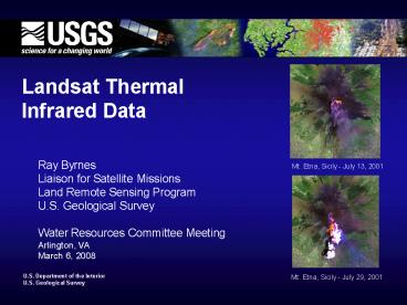
Mt. Etna, Sicily - July 13, 2001
Mt. Etna, Sicily - July 29, 2001
2
Current Thermal Data Sources via
glovis.usgs.gov or earthexplorer.usgs.gov
- Landsat 5 (1984-present) Thermal data at 10.4 -
12.5um, 120m ground resolution, 185km swath.
Global mission no data relay - Full U.S. coverage scheduled for 2008 growing
season - Could last through 2011 could fail much sooner
- Orthorectified scenes up to 20 cloud cover to be
posted on Internet in 2009 - Landsat 7 (1999-present) Thermal data at 10.4 -
12.5um, 60m ground resolution, 185km swath.
Global mission - Orthorectified scenes up to 20 cloud cover
posted on Internet - Full U.S. coverage scheduled for 2008 growing
season - Could last through 2011 could fail sooner
- ASTER instrument on NASAs Terra satellite
(1999-present) - Five bands (8.125 - 11.65um), 90m ground
resolution, 60km swath, user- driven data
acquisitions
3
Thermal Instrument Status for Landsat Data
Continuity Mission (LDCM)
- NASA
- Conducted preliminary engineering studies in FY07
on thermal instrument - Two thermal bands (10.3 - 11.3um and 11.5 -
12.5um), 185km swath, 120m - ground resolution, five-year design life
microbolometer technology - Estimates additional 90-100M needed to build
instrument - Will include location for thermal instrument in
satellite design/build - Estimates launch delay of over 1 year to build,
incorporate thermal instrument - Preparing report requested by Congress on Landsat
data continuity - USGS
- Consistently supports user requirements for
thermal capability - Has no funding identified for thermal data
processing in ground system - Landsat Science Team recommends staying with 2011
launch schedule and finding an alternative source
for thermal data
4
Key Points
- Landsat thermal data produce efficient estimates
of water consumption - Estimated 1B savings over ten years in the
western U.S. for water consumption monitoring
Morse, A. 2003. Comparison of ground water
monitoring costs as a reason to maintain the
thermal band on the Landsat Data Continuity
Mission A quick look. Report to the Idaho Dept.
of Water Resources, Boise, ID, 5 p. - Use of Landsat thermal data in lieu of
expensive and problematic pump flow
measurements, site visits, and electrical power
consumption records Allen, R.G. The Need to
Continue High Resolution Thermal Imagery - No other satellite system, current or planned,
provides the thermal imagery required for water
management in the U.S. - Thermal imaging at the Landsat scale should be a
baseline requirement for post-LDCM operational
missions supported by the National Land Imaging
Program
5
Back-ups
6
Applications of Landsat Thermal Data
- Landsat thermal data are used operationally to
monitor water consumption on a field-by-field
basis
- Water rights regulation and administration are
critically tied to identification and
quantification of water consumption on a
field-by-field basis - Allen, R.G. The Need to
Continue High Resolution Thermal Imagery - Typical irrigated field sizes in the U.S. range
from 180m to 750m on a side - Quantification of water use from Landsat using
thermal data is the only way to independently and
consistently measure water use on a
field-by-field basis - Morse, A., and R.G.
Allen. Water and the Critical Need for a Thermal
Band on Landsat
7
Water Management Issue
- From DOI (2003) Water 2025
- Preventing Crises and Conflict in the West
- Realities
- explosive population growth in areas of the West
where water is already scarce. - water shortages occur frequently in the West
- over-allocated watersheds can cause crisis and
conflict - water facilities are aging
- Water consumed
- by agriculture and
- landscape irrigation
8
Thermal Data Users
- At least 13 projects in 11 western states use
Landsat thermal data to map water consumption - USDA Agricultural Research Service identified 75
users of Landsat thermal data of which 60 were
using the data for water management - World Bank cites thermal data use for projects in
China, Mexico, Egypt, Saudi Arabia, Uzbekistan,
Kazakhstan, and Yemen - WaterWatch and SEBAL North America, Inc., claim
over 150 projects in over 15 countries use
proprietary Surface Energy Balance Algorithm for
Land (SEBAL)
9
Additional Benefits of Landsat Thermal Data
(cont.)
- Landsat thermal data are used for wildfire risk
assessment, wildfire detection, and burnt area
mapping - Supports USFS Burned Area Emergency
Rehabilitation (BAER) teams
(Images from A. Vidal)
10
Additional Benefits of Landsat Thermal Data
- Estimates of evapotranspiration rates are also
used for - mapping drought / crop stress
- projecting crop yields
- improving moisture boundary conditions to weather
forecasts - flood and streamflow forecasting
- soil moisture mapping (irrigation,
trafficability, etc.) - Landsat thermal data are used to observe natural
hazards and human impacts - volcanic hazard assessment, monitoring, and
recovery lava flow - mapping thermally active areas
- locating underground coal fires
- monitoring glaciers and glacial lakes
- mapping urban heat fluxes for air quality
modeling (urban heat island) - mapping lake thermal plumes from power plants
- monitoring non-point pollution sources
- tracking material transport in lakes and coastal
regions
Recommended
CrystalGraphics Presentations


