RIVERS OF PAKISTAN - PowerPoint PPT Presentation
1 / 23
Title: RIVERS OF PAKISTAN
1
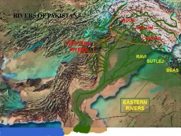
RIVERS OF PAKISTAN
INDUS
JHELUM
CHENAB
WESTERN RIVERS
AFGHANISTAN
RAVI
SUTLEJ
BEAS
INDIA
EASTERN RIVERS
IRAN
2
Gudu
Sukkur
Kotri
3
Meteoroburst Telecommunication System
4
Computer Based Flood Forecasting System
5
(No Transcript)
6
(No Transcript)
7
(No Transcript)
8
HAZARD CONTEXT
- Glacial Lake Outburst Flood (GLOF)
- There are 5218 glaciers in Pakistan with a total
of 2420 lakes - Out of which 52 lakes are considered dangerous
- An agreement for GLOF monitoring was arrived at
with ICIMOD in 2003 - Since 2003, starting from the Astor Basin, all
glacial basins have been inventoried for geo
coordinates, numbered, named and their physical
configuration have been recorded
9
SCENARIO B (MOST DANGEROUS)
Heavy to super heavy riverine flooding,
significant flash flooding and cloud burst
activity owing to heavy precipitation in
mountainous and semi-mountainous regions causing
sliding activity and severing population
segments. Cyclone activity experienced affecting
upto eight to ten districts in Sindh and/ or
Balochistan causing widespread destruction along
coastal region and massive inland flash flooding
10
HAZARD CONTEXT
- Tropical Cyclone
- Cyclone of 1999 seriously impacted Thatta and
Badin Districts (affected 0.6 million people and
caused loss of 202 lives) - Cyclone Yemyn in 2007 affected 26 districts of
Balochistan and Sindh (affected 2.5 million
people and caused loss of 400 lives)
11
HAZARD CONTEXT
- Summer Monsoons
- Summer monsoons result in heavy cyclones and
weather systems based precipitation originating
from Bay of Bengal and Arabian Sea - Water release from Tarbela and Mangla Dams
augments above - Weather systems originating from Bay of Bengal
and to a lesser extent Arabian Sea result in
occurrence of tropical cyclones in the North
Arabian Sea which impact coast of Sindh and
Balochistan
12
HAZARD CONTEXT
- Flash Floods
- NAs. Hunza, Ghizar, Astore, Gilgit Skardu
- NWFP. Charsadda, Peshawar, Mardan, DI Khan, Swat,
Mansehra, Upper /Lower Dir Chitral - AJK. Muzzafarabad, Neelum, Bagh, Kotli Bhimber
- Punjab. Sialkot, Wazirabad, Gujranwala, Gujrat,
Bhakkar, Mianwali DG Khan - Balochistan. Sibi, Jhal Magsi, Bolan, Kech,
Gwador, Kharan, Kalat, Khuzdar Lasbela - Sindh. Dadu, Qambar- Shahdadkot, Larkana,
Karachi, Hyderabad, Sanghar Badin - Urban Floods. Karachi, Hyderabad, Rawalpindi
Lahore
13
(No Transcript)
14
CYCLONE SCENARIO (Karachi Specific)
- Storm Wind
- Wind speed up to 64 120 knots (118-222 km/h)
- Wind impact commences when cyclone is 25-30 kms
from the coast
33 Knots
34-47 Knots
48-64 Knots
65-120 Knots
15
CYCLONE SCENARIO (Karachi Specific)
- Rainfall. 200 - 225 mm rainfall (9 - 10 inches)
over a period of 36 hours
15 mm/hr
33 Knots
15-25 mm/hr
25 mm/hr
16
CYCLONE SCENARIO (Karachi Specific)
- A cyclone storm making landfall in Karachi City
- Storm Surge Wave
- Height of the surge wave between 12-15 feet or
above - Wave is likely to travel up to 5 kilometres
inland - Water inflows would be regulated along the road
network and along Malir and Lyari rivers - Paralysis within 3-5 kilometres of the coastal
region - Population evacuation within 2 kilometres along
the coast
17
TSUNAMI
18
(No Transcript)
19
National Disaster Management Authority
20
December 31, 2009
20
21
(No Transcript)
22
(No Transcript)
23
(No Transcript)
24
(No Transcript)


