
PowerPointPrsentation - PowerPoint PPT Presentation
1 / 1
Title:
PowerPointPrsentation
Description:
Soil Type: Calcareous Chernozem (pH 7.6; Humus 2,2 %). Measurement Site 'Cover Crops' (Fig.2) ... Soil Type: Chernozem on loess (pH 7,6; Humus 1,8 %). Tab. 1: ... – PowerPoint PPT presentation
Number of Views:36
Avg rating:3.0/5.0
Title: PowerPointPrsentation
1
Concept of soil hydrological field measuring
sites for agricultural research purposes G.
Bodner, A. Strauss-Sieberth, W. Loiskandl,
H.-P. Kaul Institute of Agronomy and Plant
Breeding Institute of Hydraulics and Rural
Water Management
Introduction
Quantitative data about the components of the
soil water balance are fundamental in order to
design sustainable soil management systems in
plant production under water limiting conditions
and to evaluate the impact of agricultural
management decisions on the soil water
dynamics. Based on experiences in two
agricultural research projects in the semi-arid
region of Eastern Austria, we present some
remarks about a general concept, design and
sensor equipment of soil hydrological field
measurement sites.
Material and Methods
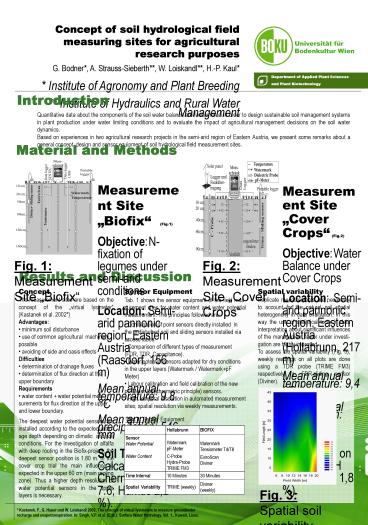
Measurement Site Biofix (Fig.1) Objective N-
fixation of legumes under semi-arid
conditions Location Semi-arid pannonic region,
Eastern Austria (Raasdorf, 156 m) Mean annual
temperature 9.8 C Mean annual precipitation
546 mm Soil Type Calcareous Chernozem (pH
7.6 Humus 2,2 ).
Measurement Site Cover Crops (Fig.2) Objective
Water Balance under Cover Crops Location Semi-ari
d pannonic region, Eastern Austria (Hollabrunn,
217 m) Mean annual temperature 9,4 C Mean
annual precipitation 491 mm Soil Type
Chernozem on loess (pH 7,6 Humus 1,8 ).
Fig. 1 Measurement Site Biofix
Fig. 2 Measurement Site Cover Crops
Results and Discussion.
Spatial variability Replicate measurements are
necessary to account for the natural soil spatial
heterogeneity in data evaluation. In this way the
use of statistical tools in data interpretation
about significant influences of the management
factor under investi-gation are highly
improved To assess the spatial variability (Fig.
3), weekly readings on all plots are done using a
TDR probe (TRIME FM3) respectively a FDR-sliding
sensor (Diviner).
Sensor Equipment
- Concept
- The measurement sites are based on the concept of
the virtual lysimeter (Kastanek et al. 2002) - Advantages
- minimum soil disturbance
- use of common agricultural machinery possible
- avoiding of side and oasis effects
- Difficulties
- determination of drainage fluxes
- determination of flux direction at the upper
boundary - Requirements
- water content water potential mea-surements
for flux direction at the upper and lower
boundary. - The deepest water potential sensors are installed
according to the expected drain-age depth
depending on climatic and soil conditions. For
the investigation of alfalfa with deep rooting in
the Biofix-project, the deepest sensor position
is 1.80 m. In the cover crop trial the main
influence is expected in the upper 60 cm (main
rooting zone). Thus a higher depth resolution of
water potential sensors in the upper layers is
necessary.
- Tab. 1 shows the sensor equipment of the field
mea-surement sites for water content and water
potential measurement. The principles followed
are - Combination of point sensors directly installed
in the undisturbed soil and sliding sensors
installed via access tubes. - Comparison of different types of measurement
(FDR, TDR, Capacitance). - Water potential sensors adapted for dry
conditions in the upper layers (Watermark /
WatermarkpF Meter) - Labour calibration and field calibration of the
new pF-Meter (psychrometric principle) sensors. - High temporal resolution in automated
measurement sites spatial resolution via weekly
measurements.
Tab. 1 Sensor Equipment
Fig. 3 Spatial soil variability, Hollabrunn
Kastanek, F., G. Hauer und W. Loiskandl 2002
The concept of virtual lysimeters to measure
groundwater recharge and evapotranspiration. In
Singh, V.P. et al. (Eds.) Surface Water
Hydrology, Vol. 1., Kuwait, Lisse.
Recommended
CrystalGraphics Presentations


