Kriging PowerPoint PPT Presentations
All Time
Recommended
Title: Slide 1 Author: miub benutzer Last modified by: miub benutzer Created Date: 4/13/2004 12:23:40 PM Document presentation format: On-screen Show
| PowerPoint PPT presentation | free to download
Z~Nn( , ) = [ si-sj; )] = V( ) Maximize. and q maximizes the profile likelihood ... of quantities such as global mean temperature need models for global covariances. ...
| PowerPoint PPT presentation | free to download
Prior on defaults to flat, but can also be normal or fixed ... 'Official' introduction to geoR is http://www.leg.ufpr.br/geoR/geoRdoc/vignette/geoRintro.pdf ...
| PowerPoint PPT presentation | free to download
A weighted linear combination of point measurements that exploits structure of ... Medusa Beowulf Cluster at NASA's GSFC. 128-processor 1.2GHz Athlon MP ...
| PowerPoint PPT presentation | free to view
Title: GEOG 578 GIS Application Author: um Last modified by: feihua Created Date: 1/17/2005 10:43:30 PM Document presentation format: On-screen Show
| PowerPoint PPT presentation | free to download
... the appropriate weights for points that are 'close' allows for anisotropy. Spatial structure is determined by modeling the empirical variogram auto ...
| PowerPoint PPT presentation | free to view
Geo479/579: Geostatistics Ch13. Block Kriging * * * * * * * * * * * Block Estimate Requirements An estimate of the average value of a variable within a prescribed ...
| PowerPoint PPT presentation | free to download
Within the CGFS area ... Began with original 79 samples. and ... available to cluster at. any time. Changes rapidly as jobs. begin and end. Xgrid Kriging Power ...
| PowerPoint PPT presentation | free to view
Analysis of ICESat Data in East Antarctica using Kriging and Kalman Filter Motivation: detect height change + surface characteristics An T Nguyen (MIT)
| PowerPoint PPT presentation | free to download
Analysis of ICESat Data in East Antarctica using Kriging and Kalman Filter. An T Nguyen (MIT) ... first laser satellite to study ice sheets. high accuracy ( 20cm) ...
| PowerPoint PPT presentation | free to download
Kriging Based Modeling of Pareto Optimal Front in Multi Criteria Optimization ... one, and at least one element in the row, negative, for Pareto-optimality. ...
| PowerPoint PPT presentation | free to view
Basis in narrowest along NW and SW Minnesota vs. traditions pattern-along ... Point forecasts are smoothed to create 'new' projected surface. corn. 55963. 55350. 56055 ...
| PowerPoint PPT presentation | free to view
Using Kriging and Interactive Graphics in Web-Based Application for Spatial-Temporal Trend Analysis of Ozone and Weather Systems in Central America
| PowerPoint PPT presentation | free to download
Stat 592A Spatial Statistical Methods peter@stat.washington.edu pds@stat.washington.edu Course content 1. Kriging 1. Gaussian regression 2. Simple kriging 3.
| PowerPoint PPT presentation | free to download
Analysis of variance. A space-time model. 9. Wavelet tools. Basic ... The prediction variance is. Some variants. Ordinary kriging ... kriging variance. An ...
| PowerPoint PPT presentation | free to download
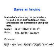
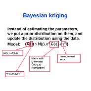
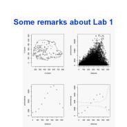
Some remarks about Lab 1. image(parana.krige,val=sqrt(parana.krige$krige.var) ... likfit(parana,nugget=470,cov.model='gaussian',ini.cov.pars=c(5000,250) ...
| PowerPoint PPT presentation | free to download
????????????????????????? interpolation ?????????(nodes)??????????????????? (Element) ... FEM; piecewise interpolation function. oving Kriging : 1D Shape ...
| PowerPoint PPT presentation | free to view
Application of Geostatistical Analyst in Spatial Interpolation. Fei Yan ... Ordinary kriging (trend removed) Ordinary cokriging (trend removed) ...
| PowerPoint PPT presentation | free to download
... kriging. where. and kriging variance. Parana data ... Parana data. Built-in geoR data set. Average rainfall over different years for May-June (dry-season) ...
| PowerPoint PPT presentation | free to download
... HW3.doc!OLE_LINK1 Spatial statistics Properties of computer experiments Computer experiments modeling Estimation Kriging example Slide 6 ...
| PowerPoint PPT presentation | free to download
Chlorophyll. physiochemical measurements. Results: Depth and Salinity ... Results: Chlorophyll. Future Work. Create more maps showing kriging of variables. ...
| PowerPoint PPT presentation | free to download
stochastic hydraulic conductivity field. kriged hydraulic conductivity ... Results with a stochastic K field. Feehley ... Stochastic hydraulic conductivity ...
| PowerPoint PPT presentation | free to download
Work by researchers, such as Neuzil and Tracy (1981), Brown (1987), Tsang and ... Kriging : uses the information from a variogram to find an optimal set of ...
| PowerPoint PPT presentation | free to download
Kriging uses statistical models that allow a variety of map outputs including predictions, prediction standard errors, probability, ...
| PowerPoint PPT presentation | free to download
Determining the Spatial Distribution of Benthos in the Western Arctic Ocean. Jon ... Source: http://www.aqd.nps.gov/ard/figure3.html. How Ordinary Kriging Works ...
| PowerPoint PPT presentation | free to download
Isobel Clark, Geostokos, Scotland. Environmental Statistics, Session 6A2 ... expected value map at un-sampled locations. Kriged standard error map. Amarillo by ...
| PowerPoint PPT presentation | free to download
Methodology: Taylor's frozen hypothesis: k=w/u: k w ... Artificial Neural Netwrok (ANN) Kriging. but with one-to-one correspondence (i.e., almost linear) ...
| PowerPoint PPT presentation | free to view
6 minutes ago - DOWNLOAD HERE : musimyangselanjutnya48.blogspot.com/?cung2=1777534526 READ [PDF] Roughing it in Africa: Roots, Roads, and Revelations | *PHOTO EDITION: Full Colour Paperback, Large Format*As 1995 wound to a close, Katherine Krige prepared to leave home. Her father died when she was five years old, but she had always dreamed of learning more about him and where he came from. With university behind her, she aimed to find out. The trick was that his hometown was 13,000 kilometer
| PowerPoint PPT presentation | free to download
To develop a robust and reliable algorithm for detecting land use/cover changes ... BISE(Best Index Slope Extraction) Kriging Interpolation. Climate Data Interpolation ...
| PowerPoint PPT presentation | free to view
6 minutes ago - DOWNLOAD HERE : https://share.bookcenterapp.com/powers/1777534526 READ [PDF] Roughing it in Africa: Roots, Roads, and Revelations | *PHOTO EDITION: Full Colour Paperback, Large Format*As 1995 wound to a close, Katherine Krige prepared to leave home. Her father died when she was five years old, but she had always dreamed of learning more about him and where he came from. With university behind her, she aimed to find out. The trick was that his hometown was 13,000 kilometer
| PowerPoint PPT presentation | free to download
Geostatistics and Archelogy Created by ExploStat. 12 ... Geostatistics and Archelogy Created by ExploStat. 15. Optimize Sampling Plan using Block Kriging ...
| PowerPoint PPT presentation | free to view
RANKING OF LOCATIONS ACCORDING TO THEIR ... APPLYING GEOGRAPHICAL INFORMATION SYSTEMS (GIS), KRIGING INTERPOLATION TECHNICS. MAP OF THE NOISE IN BADAJOZ CITY ...
| PowerPoint PPT presentation | free to view
... by work of D. Krige (South Africa) Mathematical Morphology group became ... NATO ASI, Lake Tahoe 1983. NATO ASI, Il Ciocco (Italy) 1987. Avignon, Fr. 1988 ...
| PowerPoint PPT presentation | free to download
psiA= 30 degree from North. Spatial prediction by Kriging ... 1990 survey cruise. in the Atlantic continental shelf of Long Island, New York. Change coordinate ...
| PowerPoint PPT presentation | free to view
Buzzard. EcoGrid. Spatial interpolation: Kriging. EcoGrid. Uncertainty. light green: low ... Generic tools for scale conversions in spatial data ...
| PowerPoint PPT presentation | free to view
Spatial Interpolation: A Brief Introduction Eugene Brusilovskiy * Origins Involve a set of statistical techniques called Kriging (there are a bunch of different ...
| PowerPoint PPT presentation | free to download
Guo Yu and Peng Li. Department of ECE. Texas A&M University {yuguo, pli} ... Construct Kriging models with design parameters. Build pareto fronts in nominal case ...
| PowerPoint PPT presentation | free to view
... the left image (hard information) the facies category s(u) is retrieved together ... kriging with changing anisotropy of the sand facies based on the angle ...
| PowerPoint PPT presentation | free to view
9.3 and 9.4 The Spatial Model And Spatial Prediction and the Kriging Paradigm 9.3 The Spatial Model The Spatial Model . What is it? Statistical model decomposing ...
| PowerPoint PPT presentation | free to download
Title: Dias nummer 1 Author: install Last modified by: Kasper Dalgaard Created Date: 11/10/2005 3:02:29 PM Document presentation format: Sk rmshow (4:3)
| PowerPoint PPT presentation | free to download
STAT 592A(UW) 526 (UBC-V) 890-4(SFU) Spatial Statistical Methods peter@stat.washington.edu www.stat.washington.edu/peter/592
| PowerPoint PPT presentation | free to download
Calculate air pollution fields for health effect studies. Assess deterministic air quality models against data. Interpret and set air quality standards ...
| PowerPoint PPT presentation | free to view
Title: PowerPoint Presentation Author: Antoni Magri Last modified by: phil Created Date: 3/7/2002 4:20:14 PM Document presentation format: On-screen Show (4:3)
| PowerPoint PPT presentation | free to view
Geostatistics GLY 560: GIS for Earth Scientists Introduction Premise: One cannot obtain error-free estimates of unknowns (or find a deterministic model) Approach: Use ...
| PowerPoint PPT presentation | free to download
... (WD [mi/hr]) interpolation. WD-Inverse distance weighted. WD-Spline. WD-Trend. WD ... Daily Penman (ETo Inches) ETc = Kc . ETo. Kc is for the crop of Interest ...
| PowerPoint PPT presentation | free to view
(elevation, oil spill, air pollution, a chemical in a lake) ... (prediction, error of estimation, quantile map, and probability map) The Geostatistical Analyst: ...
| PowerPoint PPT presentation | free to view
Applications in GIS/Geographic Data Analysis. Lecture 6: Point Interpolation ... Fits a piece-wise polynomial function to a neighborhood of sample points ...
| PowerPoint PPT presentation | free to view
The semi-variogram based error variance model: (2) Minimize the ... uncertainty information is provided (5) undesired drastic change of attribute values ...
| PowerPoint PPT presentation | free to view
Title: No Slide Title Author: David L.Combs Last modified by: nsu Created Date: 10/26/1999 8:37:18 PM Document presentation format: On-screen Show Company
| PowerPoint PPT presentation | free to download
Title: Title GIS PROJECT Author: SPenmetsa Last modified by: gisuser Created Date: 4/19/2006 6:13:22 PM Document presentation format: On-screen Show
| PowerPoint PPT presentation | free to view
This presentation has not been formally reviewed by EPA. ... 1994 Southern California Bight Pilot Project. EMAP design. 77 samples ...
| PowerPoint PPT presentation | free to download
A Digital Elevation Model is a bare-earth raster grid referenced to a vertical datum. The DEM can even be obtained from stereo digital aerial imagery at various resolutions, depending on the quality and scale of the imagery.
| PowerPoint PPT presentation | free to download
Assumed field is homogeneous and isotropic. ... Estimated field based on observations and correlation matrix (assumes the ... Anisotropy ...
| PowerPoint PPT presentation | free to view
... theory-free. Disadvantages. theory-free. directional effects ... A set of weights i unique to x. chosen such that the estimate is. unbiased. minimum variance ...
| PowerPoint PPT presentation | free to download
EPA Region VII IMPROVE monitors data (i.e. speciation filters) ... Data measured every third day. Obtained from VIEWS Network. Data ...
| PowerPoint PPT presentation | free to view
n is the location n di is the pollutant i ... Pollutants were measured in 60 different locations (sample points) with a mobil monitoring unit ...
| PowerPoint PPT presentation | free to view


