
Hydrography PowerPoint PPT Presentations
All Time
Recommended

Hydrographic Activities for the Environmental Protection and Maritime Transport Control in the Gulf
| PowerPoint PPT presentation | free to download

20 1440 'faisceaux' 20 en longueur, 1 5 en largeur. Faisceaux transmis. 1 5 en ... Intersection des faisceaux transmis et des faisceaux re us ...
| PowerPoint PPT presentation | free to download

Hydrography. Atlantic: Pacific: MP01: 125 CTD Casts. MP03: 105 CTD Casts. MP04: 6 CTD Casts ... Mass Flux: 26.39 mg/d*m2. Biomass: 29.1x 10^s trichomes/m2. MP03 ...
| PowerPoint PPT presentation | free to view

The EU EMODNET-Hydrography pilot project EMODNET-Hydrography objectives EU (DG MARE) : service contracts for creating pilot components of EMODNET EMODNET : To migrate ...
| PowerPoint PPT presentation | free to view

Promote the use of hydrography for the safety of navigation & all other marine ... continue to champion capacity building to enhance Hydrography in the region ...
| PowerPoint PPT presentation | free to download

S-100 Hydrographic Geospatial Data Standard ... Hydrography and Cartography in Inland Waters WG. Scoping study. Regional Hydrographic Commissions ...
| PowerPoint PPT presentation | free to view

In future, get local jurisdiction or tribal support for funding requests ... as outlined in Objective One of the Mapping Washington Water Resources funding request. ...
| PowerPoint PPT presentation | free to view

Current, wave and sea-level measurements, modeling of tsunami ... ADIOS-FP5. ARALKUM-FP5. BIOMARE-FP5. PROMED-FP6. INSPIRE-FP6. 2 TBTK. 3 NATO-SfP. 7 NATO-Link ...
| PowerPoint PPT presentation | free to download

HYDROGRAPHY OF THE NAVO CENCAL REGION FOR DEC01. LT Kitch Kennedy. OC3570. What is hydrography ... hydrography is the branch of our field which looks ...
| PowerPoint PPT presentation | free to view

Data Stewardship and Maintenance for the National Hydrography Dataset. Gladys Conaway ... The NHD is the hydrography layer of the National Map. Current NHD ...
| PowerPoint PPT presentation | free to view

Exchanging and Maintaining Minnesota Hydrographic Data ... Hydrography. Dataset Plus. Nonpoint Source Grants. GRTS. Water Quality Standards. WQSDB ...
| PowerPoint PPT presentation | free to view

Environmental Protection and Maritime Transport Control in the. Gulf of Honduras Project ... and control from maritime transport-related pollution in the major ...
| PowerPoint PPT presentation | free to download

Complementarity of the Repeat Hydrography and Argo Programs. Gregory Johnson ... Potential vorticity is low. Subtropical Mode Water. Hanawa & Talley (2001) ...
| PowerPoint PPT presentation | free to view

Maritime commerce is the basic element for a nation's economy ... infrastructure which includes topography, geodesy, geophysics, and meteorology ...
| PowerPoint PPT presentation | free to view

At the International Repeat Hydrography and Carbon Workshop (Shonan Village, ... Scientific justification for repeat hydrography ...
| PowerPoint PPT presentation | free to view

Title: PowerPoint Presentation Last modified by: marvin cango Created Date: 1/1/1601 12:00:00 AM Document presentation format: On-screen Show Other titles
| PowerPoint PPT presentation | free to view

the specific science aims of CLIVAR and the ocean carbon and ... Overview of Ongoing ocean observation programs (international, domestic) ...
| PowerPoint PPT presentation | free to view

Environmental Protection and Maritime Transport Pollution Control in the Gulf of ... pollution control. Component 2: Updating the TDA, developing a region ...
| PowerPoint PPT presentation | free to view

Title: Unit 4.a. Application of Hydro-Cartographic products and services to shipping Author: ukhouser Last modified by: UKHOUSER Created Date: 10/3/2005 4:39:51 PM
| PowerPoint PPT presentation | free to download

Spatial and Temporal Variability of Hydrography in the Vicinity of the Main Endeavour Field ... were made throughout the hydrographic survey on a nearby mooring ...
| PowerPoint PPT presentation | free to download

Professional Assistant (Hydrography) International Hydrographic Organisation. Monaco ... 'IHO Standards for Hydrographic Surveys' ...
| PowerPoint PPT presentation | free to view

Hydro Networks in GIS Network model Flow on Networks Hydrologic networks Linear referencing on networks National Hydrography Dataset National Hydrography Dataset ...
| PowerPoint PPT presentation | free to download

Providing conceptual schemas for describing and manipulating the spatial characteristic ... Lake = AreaFeature featureType='Hydrography::WaterBody', extent = S3 ...
| PowerPoint PPT presentation | free to view

Making the NHD Flow: Adding Hydrology to the Hydrography By Tim Bondelid RTI International Jeanne Game RTI International Cindy McKay Horizon Systems
| PowerPoint PPT presentation | free to view

L hydrographie et les principales villes. Cherbourg. Coutances. Lessay. Saint-L . Vire. Avranches. Bayeux. Caen. Trouville/mer. Argentan. Lisieux. Mortagne au-Perche
| PowerPoint PPT presentation | free to download
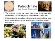
... and d18O geochemical temperature proxies Sr/Ca partly controlled by algal symbionts d18O partly controlled by local hydrography and biofractionation Ice cores ...
| PowerPoint PPT presentation | free to download

The FleetLink project is a partnership between ... quality, synoptic environmental (hydrography, meteorology, biology) data from the coastal ocean. ...
| PowerPoint PPT presentation | free to download

National Hydrography Dataset (NHD) NHD Reach Indexing Tool (NHD-RIT) ... National Hydrography Dataset (NHD) ... Line Graph (DLG) hydrography and the EPA Reach ...
| PowerPoint PPT presentation | free to download

Management of land, property and hydrographic information ... Commission 4 - Hydrography. Working Groups 2002-2006. Strategic Partnerships ...
| PowerPoint PPT presentation | free to download

Hydrography. Governmental. Units. Orthoimagery. Geodetic Control. Air ... Hydrography. Gov. Units. Orthoimagery. Base Standard. Transportation. Geodetic Control ...
| PowerPoint PPT presentation | free to download

SSHIAPHydro. A Western Washington Hydrography, Network and Drainage Geo-database Framework. ... Hydrography data. comes from many sources. Networks built on ...
| PowerPoint PPT presentation | free to view

... transfer standard to meet all Hydrographic requirements, but in reality has been ... S-57 no longer considered a standard 'just for hydrography' ...
| PowerPoint PPT presentation | free to view

Underwater Acoustic Communication Market research report categorizes global market by Interface Platform, Communication Range, Application (Environmental Monitoring, Pollution Monitoring, Climate Recording, Hydrography, Oceanography), End User, and Geography
| PowerPoint PPT presentation | free to download

Hydrography. Population. Coastline/Boundaries. Elevation ... Hydrography. Population. Coastline/Boundaries. Elevation. Vegetation. Soils/Surface Materials ...
| PowerPoint PPT presentation | free to view

Applications for 1- 5 cm Real-Time Positioning Land surveying Remote sensing / photogrammetry Hydrography Machine control (construction, precision agriculture) ...
| PowerPoint PPT presentation | free to download

Information comes from aerial photography, using survey ... Hydrography. rivers. streams. lakes. coastline. Vegetation. mangroves. forest. Culture. roads ...
| PowerPoint PPT presentation | free to view

... for hydrographic resurvey ... (and past) occupation of sections for hydrography & carbon. ... giving attention to repeat hydrography/carbon but little to ...
| PowerPoint PPT presentation | free to view

Hydrography. Orthoimagery. There are 7 common geographic ... Hydrography. Imagery. Technical Context. Facilitates people's ability to contribute and use data ...
| PowerPoint PPT presentation | free to view

Topography & Hydrography. Digital Elevation Model (DEM) 30 m. USGS National Elevation Dataset ... National Hydrography Dataset. http://nhd.usgs.gov/data.html ...
| PowerPoint PPT presentation | free to view

Hydrographic features for making maps. A national stream addressing system ... Hydrography. Dataset. WATERS Data Architecture. Nonpoint Source Grants. GRTS ...
| PowerPoint PPT presentation | free to view

Plans au 1/20.000 : Al_Mabtaqa (limites administratives. 121 feuilles dont 8 ne sont pas ... Equipements divers, Hydrographie, Limites administratives, orographie. ...
| PowerPoint PPT presentation | free to view

Strategy: Repeat Hydrography, CO2 & Tracers. Conduct ongoing program in ... CLIVAR/CCSP CO2 Repeat Hydrography Program. Repeat Hydrography Schedule and Measurements ...
| PowerPoint PPT presentation | free to view

Hydrography. Elevation. Roads and Railroads. Cadastral ... Hydrography / Hydrology / drainage network/ River and lake basins. Hydrogeology. Coastlines ...
| PowerPoint PPT presentation | free to download

H: The position and height of the satellite is computed, ... Hydrography / surveying Bathymetry - GPS. Operational sea level services ...
| PowerPoint PPT presentation | free to view

hydrography, transportation... Title: Dakota Aquifer. Online linkage: ... hydrography, transportation... Topic: Dakota Aquifer. Adress Id: ...
| PowerPoint PPT presentation | free to view

Biome boundaries are predictive of hydrography. Changes in biome size and distributions are bellwethers for cyclical and secular ...
| PowerPoint PPT presentation | free to download

The Australian Spatial Data Infrastructure a stock take. Steve ... Hydrography. Transportation. Cadastral. Core Data. Social. Economic. Biological. Land cover ...
| PowerPoint PPT presentation | free to view

Many agencies are interested in regional scale monitoring of stream networks and ... Frame: USGS 1:100,000 scale digital hydrography (perennial and intermittent) ...
| PowerPoint PPT presentation | free to view

Electronic data base , operating system, computer ... Hydrography. Inland waterways. Land cover. Limits. Aids to Navigation. Obstructions. Port Facilities ...
| PowerPoint PPT presentation | free to view

To do this, and using the initial priorities for the NANOOS observing systems ... Plankton, fish, mar mam, birds, trophics, hydrography ...
| PowerPoint PPT presentation | free to download

Alabama Geographic Information Council. The National Spatial ... Hydrography. NSDI Components. Metadata. Explanation or textual description of data resources ...
| PowerPoint PPT presentation | free to view
Data: bathymetry, hydrography, surface fluxes global climatological datasets are ... the nonlinear equation of state in a adiabatic part and a compressible part. ...
| PowerPoint PPT presentation | free to download
... Data, conservation tillage data (NASS/CTIC), National Hydrography Data (med. ... Adjust to reflect percent of county in conventional tillage (CTIC) ...
| PowerPoint PPT presentation | free to download

National Elevation Dataset (NED) National Hydrography Dataset (NHD) Watershed ... GTOPO30 - 1 km Digital Elevation Model of the Earth. Drainage in North America ...
| PowerPoint PPT presentation | free to download

GIS Database Development (Arc Hydro) and. HSPF Visualization, Lake Jesup ... What is Arc Hydro? Primarily a geodatabase template ... Hydrography Feature Dataset ...
| PowerPoint PPT presentation | free to view

Sonoran Desert Network Bird Monitoring Objectives: ... Riparian and Xeroriparian (hydrography) High-elevation Terrestrial ( 5000' ...
| PowerPoint PPT presentation | free to view