
Hydrogeologic PowerPoint PPT Presentations
All Time
Recommended
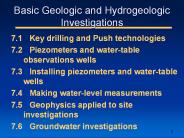
Title: No Slide Title Author: ama Last modified by: ama Created Date: 9/7/1999 9:59:08 AM Document presentation format: On-screen Show Company: TAMU
| PowerPoint PPT presentation | free to download

Today due to shortage of water, groundwater is considered as the main source of water but groundwater due to various activities often contains contaminated particles. So it is necessary to improve the groundwater quality so that it can be used for various purposes. ECOH, the environmental services provider firm can help you in improving groundwater quality through hydrogeology investigation services that involves the installation of several boreholes and groundwater observation wells, advanced into the water bearing zones across the subject site, and possibly adjacent properties.
| PowerPoint PPT presentation | free to download

Title: Can Contamination potential of ground water to pesticides be identified from hydrogeological parameters? Author: bdixon Last modified by
| PowerPoint PPT presentation | free to view

Watershed-Scale Hydrogeologic Analysis and Paleohydrologic Modeling With Applications for Predicting Abandonment of Prehistoric Settlements, Mesa Verde Region,
| PowerPoint PPT presentation | free to download

Deeper (605') well in basalt (Wanapum and uppermost Grande Ronde) Static ... The lower part of the basalt aquifer system has not been recharged since the end ...
| PowerPoint PPT presentation | free to download

1 Geological Institute BAS. 2 National Institute of Meteorology and Hydrology - BAS ... are built from Proterozoic marbles; other karstic springs drain Triassic ...
| PowerPoint PPT presentation | free to view

Hydrogeological Modeling of the Pullman-Moscow Basin Basalt Aquifer System, WA and ID Joan Wu, Farida Leek, Kent Keller Washington State University
| PowerPoint PPT presentation | free to view

Special Paper no. 1, National Cave and Karst Research Institute, Carlsbad, NM, U.S.A.160 p. ... interpreted and used for practical and scientific purposes in ...
| PowerPoint PPT presentation | free to download

Law, Politics, and the Flow of Water in the Klamath Basin. Prepared by: Aaron ... The water California takes represents a major variable in flows at the end of ...
| PowerPoint PPT presentation | free to download

As a fairly rare phenomenon, the formation of geysers is due to particular hydrogeological conditions that exist in only a few places
| PowerPoint PPT presentation | free to download
Construct accurate representations of hydrogeological systems ... Homogeneity, Isotropy, simple geometry, simple initial conditions...
| PowerPoint PPT presentation | free to download

15x vertical exaggeration. 6. Hydrogeologic Units. 7. Major Surface. Water Sources. Within Model Area ... Ozark and Springfield aquifers are principal water ...
| PowerPoint PPT presentation | free to view

Crystalline rocks with glacial cover Piedmont and Blue Ridge Sandstone and diabase in rift basins Limestone Multi-level completion Other Hydrogeologic Settings in the ...
| PowerPoint PPT presentation | free to download

... definition of Spring Water incorporated into Maine Bottled Water Regulations. Water withdrawn must show a hydrogeologic and geochemical connection to an ...
| PowerPoint PPT presentation | free to view

Lack of a global international instrument covering these resources ... Hydrogeological sketch map of the SASS (Syst me Aquifer du Sahara Septentrional) ...
| PowerPoint PPT presentation | free to view
Infer important hydrologic and hydrogeologic data Prediction scaled sensitivities (pss) with composite scaled sensitivies (css) and parameter correlation ...
| PowerPoint PPT presentation | free to download

Draft Guidance Module 4: Surface Water Vulnerability Analysis ... may be appropriate for complex hydrogeological settings (e.g., karst terrain) ...
| PowerPoint PPT presentation | free to view

ARD treatment of Swift Gulch Drainage in the Little Rocky Mountains of North Central Montana By: John L. Kill Eagle Hydrogeological Engineering
| PowerPoint PPT presentation | free to download

The basalt aquifer between Syria and Jordan (mostly hydrogeological investigations) ... BASALT AQUIFERSYSTEM IN JORDAN AND THE SYRIAN ARAB REPUBLIC. 10/8/09. 17 ...
| PowerPoint PPT presentation | free to download

... for the prevention and prevision of the hydraulic and hydrogeological risk; ... good practices on the Prevention, Prevision and Fight against the hydraulic and ...
| PowerPoint PPT presentation | free to view

alluvium. GROUNDWATER: - alluvium, - carst. Hydrogeological map. Borders with Croatia: a) alluvium aquifers, - rivers crossing the border: Mura, Drava, Sava - rivers ...
| PowerPoint PPT presentation | free to view

... analysis of samples, hydrogeological data as well as data on seismicity etc. ... published papers, geological maps, seismicity maps, other geological or ...
| PowerPoint PPT presentation | free to view

... for the prevention and prevision of the hydraulic and hydrogeological risk; ... good practices on the Prevention, Prevision and Fight against the hydraulic and ...
| PowerPoint PPT presentation | free to view

The Islamic University of Gaza Faculty of Engineering Civil Engineering Department EENV 5326 Groundwater Modeling
| PowerPoint PPT presentation | free to download

geometry of the system: data on the roof and subface of lithological strata; ... Lithology and relief of pre-Quaternary deposits. Lithology of Quaternary deposits ...
| PowerPoint PPT presentation | free to download

Explore the cutting-edge groundwater infiltration process pioneered by Parjana Engineering, a game-changer in sustainable water management. Discover how Parjana's innovative technology redefines the way we harness and replenish groundwater, safeguarding our water resources for future generations. Learn how this groundbreaking solution transforms urban environments, mitigates flooding, and ensures a sustainable water future. https://parjanaengineering.com/
| PowerPoint PPT presentation | free to download

Using Ground-Water Model Predictions and the ppr and opr Statistics to Guide Data Collection
| PowerPoint PPT presentation | free to download

Ground Water Contributions to Death Valley from Southeast California Desert Basins ... Ground Water Flow to Death Valley (cubic meters per day) 30,000. Total ...
| PowerPoint PPT presentation | free to download

Development of respective national ... Project in Central Asia Kyrgyzstan Uzbekistan Tajikistan FOUR SITES SELECTED Rapid risk assessment and ranking of environment ...
| PowerPoint PPT presentation | free to view

Earth Sciences Sector. Groundwater Mapping. GROUNDWATER MODELLING: FROM ... Earth Sciences Sector ... in interrelated disciplines of Earth sciences ...
| PowerPoint PPT presentation | free to view

PREVENTION PROGRAM AND DISASTER PREPAREDNESS TECHNICAL COMMITTEE ON EARLY WARNING SYSTEM National Emergency Commission-CNE Ruben Valbuena Volunteer university UN'S UNITE
| PowerPoint PPT presentation | free to download

Overview on Geo 3D Project Improvement of the TBM tunneling process by using real time information Constantin Radu Gogu Daniel Monfort Violeta Velasco
| PowerPoint PPT presentation | free to view
Title: schlemon mentor program Author: Mark Osten / Ken Quinn Last modified by: Computer Systems Manager Created Date: 5/2/1997 11:08:24 AM Document presentation format
| PowerPoint PPT presentation | free to download

Brant Fisher, DWRP, Environmental Engineer, (517) 335-9187, fisherb@state.mi.us. Rick Mandle, LWMD, Groundwater Modeling Program Manager, (517) 241-9001, mandler ...
| PowerPoint PPT presentation | free to view

Temporal Representation of time varying data ... GeoRasters also store hydraulic properties such as transmissivity, conductivity, ...
| PowerPoint PPT presentation | free to view

Low hydraulic conductivity. Not overlie sole source. Outside floodplain area ... Collect and assess site-specific engineering and environmental data ...
| PowerPoint PPT presentation | free to view

3D STRUCTURE MODELING AT THE FEDERAL INSTITUTE FOR GEOSCIENCES AND NATURAL RESOURCES (BGR), GERMANY Birgit Willscher, Rolf R diger Ludwig, Bettina K hn
| PowerPoint PPT presentation | free to view

The occurrence and environmental fate of pharmaceuticals and personal care products from treated was
| PowerPoint PPT presentation | free to view
Arc Hydro Groundwater Data Model Gil Strassberg, David Maidment University of Texas at Austin Norman Jones, Brigham Young University Outline Background: objectives ...
| PowerPoint PPT presentation | free to download

How to maintain a critical mass. How to build and strengthen opportunities for interdisciplinary training. Some Approaches to Maintaining Critical Mass ...
| PowerPoint PPT presentation | free to download

Arc Hydro Groundwater Data Model
| PowerPoint PPT presentation | free to view

B = Brig. C = Cr telongue. F = Feldsberg. K = Konstanz Lake. L = L man Lake. V = V troz ... (Fig. 3) H Brig-L man. Experimental variogram. 3-D Groundwater Pegase ...
| PowerPoint PPT presentation | free to view

Arc Hydro groundwater data model: a data model for groundwater systems within ArcGIS
| PowerPoint PPT presentation | free to view

An Overview of Environmental Investigations January 22, 2002 Presented by: DuPont Corporate Remediation Group Today s meeting... Provide an overview of the basic ...
| PowerPoint PPT presentation | free to view

Adequate Buffer zone and at least five years operation for ... Airborne debris. Visual impact. Property value. Ultimate use. Capped and terminated. Our planet ...
| PowerPoint PPT presentation | free to view

Aquifer Storage and Recovery (ASR) and. Artificial ... Seepage systems, Injection wells. Recharge Method. Primarily drinking water. Primarily irrigation ...
| PowerPoint PPT presentation | free to view

evaluation and development of ground water resources of ada'a becho plains for irrigation project engida za*, tilahun a*, dr. seifu k* and dr. yilma*
| PowerPoint PPT presentation | free to view

Sonoma County Water Agency ... County of Sonoma. Cal American Water Co. Study ... Land Use Maps & Water Use Estimates - Santa Rosa Plain. Historical Land Use ...
| PowerPoint PPT presentation | free to download

FRESH WATER AND SALTED WATER IN PANNONIAN DEPOSITS FROM ... Emil RADU, Catalina RADU. National Institute of Hydrology and Water Management, Bucharest, Romania ...
| PowerPoint PPT presentation | free to view

90 percent of our business comes from repeat clients and referrals ... Phase I Environmental Site Assessments (ESAs) Phase II ESAs ...
| PowerPoint PPT presentation | free to view

Wake County Comprehensive Groundwater Investigation. Groundwater Study Advisory ... Gneiss, Felsic. Igneous, Massive Intrusive. Metaigneous, Felsic. Metaigneous, Mafic ...
| PowerPoint PPT presentation | free to view

Birgit Willscher, Rolf R diger Ludwig, Bettina K hn ... not applicable for complex faulting (ramps, overthrust faults) 4 Conclusions ...
| PowerPoint PPT presentation | free to view

Braidwood Site Investigation Team. Raimonde Drilling Corporation. GZA ... Stability of Niagara Falls - Corps of Engineers; Stress measurements, rock mechanics ...
| PowerPoint PPT presentation | free to view

Title: PowerPoint Presentation Author: P. Allen Macfarlane Last modified by: P. Allen Macfarlane Created Date: 3/23/2005 3:26:20 PM Document presentation format
| PowerPoint PPT presentation | free to download

Pilot Project - Woodstock & Ingersoll ... drilled 7 wells - 3 nested (shallow/deep) and 4 shallow - 3 in Woodstock and 4 in Ingersoll ...
| PowerPoint PPT presentation | free to view

Theoretic and real possibilities of cleaning subsurface and groundwater from PH in Lithuania. ... vacuum extraction; bioremediation using bacteria.
| PowerPoint PPT presentation | free to view