A1261611006LeYkZ - PowerPoint PPT Presentation
Title:
A1261611006LeYkZ
Description:
... Data Support Team has developed IDL-based tools for visualizing these data products. ... sounder that provides atmospheric information in the presence of clouds, ... – PowerPoint PPT presentation
Number of Views:20
Avg rating:3.0/5.0
Title: A1261611006LeYkZ
1
Visualization Of AIRS Level-1B and Level-2 HDF
Data Sets
Jason Li1, Sunmi Cho2 and Jianchun Qin2 1. L-3
Communications GSI 2. Science Systems and
Applications Inc GES DAAC, NASA Goddard Space
Flight Center
The Atmospheric Infrared Sounder (AIRS) is an
ultra-high spectral resolution infrared grating
spectrometer aboard the EOS Aqua satellite. AIRS
and its partner sounder the Advanced Microwave
Sounding Unit-A (AMSU-A) measure humidity,
temperature, cloud properties, and the amounts of
greenhouse gases. AIRS also reveals land and sea
surface temperatures. Five AIRS flagship science
products are publicly available to the user
community. They are AIRS IR radiance, AIRS
Vis/NIR radiance, AMSU brightness temperatures,
cloud clear radiance and core retrieval products.
The AIRS Data Support Team has developed
IDL-based tools for visualizing these data
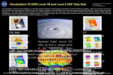
products. Hurricane Isabel is shown below from
an unique perspective of AIRS, for September 16,
2003.
VIS_Rad (AIRVBRAD/Level-1B) AIRS calibrated
Vis/NIR radiances. This image is a false color
composite using 0.71-0.92 µm, 0.58-0.68 µm and
0.40-0.44 µm bands. The nadir pixel resolution is
2.3 km.
CC (AIRI2CCF/Level-2) AIRS IR radiances for each
cloud-free AMSU footprint. Cloud bands from
Isabel is clearly carved out in this image.
Measurements are made at 2378 spectral channels
just like the AIRIBRAD product.
Hurricane Isabel viewed 220 miles up from a
vantage point of the International Space Station.
Astronaut Edward Lu captured this spectacular
image on September 15, 2003. Isabel made land
fall as a Category 2 hurricane (on the
Saffir-Simpson scale) three days later, causing
large area blackout, storm surge and fatalities
in the Mid-Atlantic states.
11.1 µm Brightness Temperature
AIRS_Rad (AIRIBRAD/Level-1B) AIRS calibrated IR
radiances. There are 2378 channels to choose
from, covering 3.7-15.4 µm spectral region. The
nadir pixel resolution is 13.5 km.
RetStd (AIRX2RET/Level-2) core AIRS physical
retrieval at each AMSU footprint. It consists of
estimates of cloud and surface properties,
profiles of retrieved temperature, water vapor,
ozone etc. It has 28 standard pressure levels for
profiles, from 1000 mb to 0.2 mb.
Hurricane Isabel
AMSU_Rad (AIRABRAD/Level-1B) AMSU-A1 and A2
combined calibrated brightness temperatures.
AMSU-A is primarily a temperature sounder that
provides atmospheric information in the presence
of clouds, which can be used to correct the AIRS
IR measurements for the effects of clouds. The
nadir pixel resolution is 40.5 km.
RetSup (AIRX2SUP/Level-2) support product. It
has 100 pressure levels for atmospheric profiles
and contains intermediate results of the
retrieval process and abundance of tracer gases.
In this plot, the cross track plane of AIRS cuts
through the eye of the Hurricane Isabel. This
data product is catered to knowledgeable users
with specialized applications.
GES DAAC AIRS Data Support Site
http//daac.gsfc.nasa.gov/atmodyn/airs
GES DAAC AIRS Data Support Email
atmdyn-dst_at_daac.gsfc.nasa.gov


