Deltaic Depositional Systems - PowerPoint PPT Presentation
Title:
Deltaic Depositional Systems
Description:
Deltaic Depositional Systems Modern and Ancient Arno River Delta (Med) (a wave dominated and engineered delta) * * Deltaic Depositional Systems Locus of voluminous ... – PowerPoint PPT presentation
Number of Views:90
Avg rating:3.0/5.0
Title: Deltaic Depositional Systems
1
Deltaic Depositional Systems
- Modern and
- Ancient
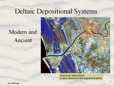
Arno River Delta (Med) (a wave dominated and
engineered delta)
2
Deltaic Depositional Systems
- Locus of voluminous terrigenous clastic sediment
accumulation where fluvial dispersal systems
encounter standing water - Most common in subsiding basin-settings (passive
continental margins) where major river systems
transport large volumes of sediment.
Modern Gulf of Mexico And the Mississippi River
Delta (a river dominated delta)
3
Importance Of Deltas
- Site of substantial fossil fuel resource
accumulation - Coal, Oil, and Natural Gas
4
Importance Of Deltas
- Diverse and prolific ecosystems
- Common site of large human population centers
Nile River Delta (Med Sea) (an engineered,
wave/river dominated delta)
Tigris Euphrates River Delta (Persian Gulf)
5
Main Geological Characteristics Of Deltas
- Isopach thick... major stratigraphic component of
(Terrigenous Clastic) sedimentary basin fill
Mississippi Delta
6
Main Geological Characteristics Of Deltas
- Regressive - Progradational successions
- Abandonment Transgressive Stage
7
Main Geological Characteristics Of Deltas
- Contemporaneous non-marine - marginal marine - to
basinal depositional systems - Numerous sub-environments (each of a scale
similar to that of most other depo systems)
8
Delta Types
- Constructional Deltas
- Dominated by the fluvial system
- strongly progradational/regressive
- Lobate Elongate
- Destructional Deltas
- Dominated by marine processes
- common marine reworking with transgressive
intervals - Cuspate (transitional to interdeltaic systems)
9
Main Processes Influencing Delta Depositional
Systems
- Climate
- Relief
- Fluvial Discharge (water volume and time
variation) - Sediment load and type
- River mouth processes
- Tidal Processes
- Wave energy
10
Main Delta Sedimentary Facies
- Generic River-Dominated Delta Model
- large rivers
- broad shelf
- low wave energy
- low tidal range
11
Main Delta Sedimentary Facies
- Generic River-Dominated Delta Model
- Upper Delta Plain
- above highest high tide
- low gradient/ meandering river systems
- fresh water lakes swamps
12
Main Delta Sedimentary Facies
- Generic River-Dominated Delta Model
- Lower delta plain
- between the tides
- Distributary channels
- Inter-distributary bay fill
- levees
13
Main Delta Sedimentary Facies
- Generic River-Dominated Delta Model
- Subaqueous Delta (Delta Front)
- below lowest low tide
- distributary mouth bar - bar finger sands
- bays
14
Delta Front Progradation
15
Main Delta Sedimentary Facies
- Generic River-Dominated Delta Model
- Prodelta
- Offshore transitional to open marine
- Normal Marine Shelf
- High biological productivity
- Abundant slumps and syndepositional deformation
16
Generic Wave Dominated Delta Model
- High wave energy, open coasts, strong longshore
currents
- Non-marine, swamp to Eolian dune
- Arcuate to strand-parallel sand dominated facies,
barrier island sequences
Rhone River Delta (Med) (a wave dominated delta)
17
Generic Tide Dominated Delta Model
- High Tidal Range
- Extensive lower delta plain/tidal mudflats
- Shore perpendicular, elongate sand dominated
facies, tidal channel deposits
Ganges - Brahmaputra River Delta (Indian
Ocean) (a tide dominated delta)
18
Transgressive Mississippi Delta Model
19
Transgressive Mississippi Delta Model
20
Transgressive Mississippi Delta Model
21
Environmental Issues in Modern Deltas
- Damming, Dredging, Diverting
- Coastal Land loss (erosion/subsidence)
- Coastal Pollution
- Nutrient loading,
- anoxic events
- Petroleum contamination
- Habitat Destruction
- land loss,
- contamination, and
- development
22
Environmental Issues in Modern Deltas
- Mississippi Delta Coastal Land loss
- Louisiana's coastal wetlands, a national resource
supporting 30 of the nation's fisheries and most
of the wintering ducks in the Mississippi Flyway,
are at risk from the annual conversion of an
estimated 35-45 mi2 of wetlands to open water. - Louisiana's wetland loss rate is the highest of
any state in the nation. The processes causing
wetland loss in coastal Louisiana are complex and
varied. - Huge energy infrastructure
- Louisiana roads, pipelines, and transmission and
distribution systems transport more than 30
percent of the nations oil and natural gas
supplies through the state
23
Coastal Elevation in Louisiana
24
Natures Revenge
- Louisianas vanishing wetlands


