Anatomy of a Wildfire the B - PowerPoint PPT Presentation
1 / 27
Title: Anatomy of a Wildfire the B
1
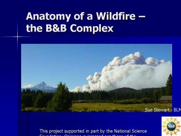
Anatomy of a Wildfire the BB Complex
Sue Stewart - BLM
This project supported in part by the National
Science Foundation. Opinions expressed are those
of the authors and not necessarily those of the
Foundation.
2
NASA Earth Observatory Satellite
3
Types of Wildfire
- Ground Fire smoldering combustion of compacted
organic material, typically slow-moving - Surface Fire combustion of above-ground fire
fuels (leaves, grass, herbs, downed wood) - Crown Fire combustion of tree canopies ignited
from below or spreading from tree crown to tree
crown
4
Fire Behavior under Historical vs. Current
Conditions
US Forest Service
5
Fire History in Central Oregon 1900 - 2004
- Decade Acres burned of Total Area
- 1900-1909 11,913 5
- 1910-1919 45,564 18
- 1920-1929 5,491 2
- 1930-1939 699 0
- 1940-1949 13,761 5
- 1950-1959 1,123 0
- 1960-1969 10,640 4
- 1970-1979 5,605 2
- 1980-1989 5,932 2
- 1990-1999 25,519 10
- 2000-2004 128,817 51
The Oregonian
6
USDA Forest Service
US Forest Service
7
FRCC 1 low departure FRCC 2 moderate
departure FRCC 3 high departure
The Nature Conservancy
8
B B Complex Fire
Coast Range
Willamette Valley
Cascade Range
Nasa Earth Observatory
9
Bear Butte Fire20 August 2003
Mt. Jefferson
USDA Forest Service, Sue Stewart
10
Booth Fire
Three-fingered Jack
USDA Forest Service - Pete Miles
11
NASA Earth Observatory Satellite
12
USDA Forest Service
13
USDA Forest Service
14
B B Complex Post-fire Assessment
- Burned Area Emergency Rehabilitation (BAER) Team
- Identifies fire-caused changes in soils that
threaten life, property or natural resources - Uses both remote sensing and on-the-ground
surveys - Prescribes and implements treatments to minimize
these hazards
15
- Burned Area
- Reflectance
- Classification
- (BARC) Map based
- on satellite imagery
Dark Green no burn Light Green low
severity Yellow moderate severity Red high
severity
Oregon Websites and Watersheds Project
16
BAER Soil Burn Severity Class Criteria
17
- B B Complex
- BAER Soil Burn
- Severity Map
BAER BARC Ground Survey Data
Dark Green no burn Light Green low
severity Yellow moderate severity Red high
severity
Oregon Websites and Watersheds Project
18
Burn severity vs. intensity
- Severity a measure of the effects of a
wildfire, particularly on soils - Intensity a measure of the amount and duration
of heat applied during the wildfire
19
Post-fire Recovery and Rehabilitation
- Timber salvage
- Thinning and slash removal
- Reforestation
- Riparian area rehabilitation
- Removal of hazard trees
- Monitoring for invasive species
- Monitoring for erosion
- Road decommissioning
20
Post-fire rehabilitation
USDA Forest Service
21
Road Decommissioning
- Before After
USDA Forest Service
22
The Repeat Photography Grid Project
Abbott Butte, Deschutes Co., Oregon
Oregon Websites and Watershed Project Inc.
23
B B Complex Fire Effects
- 91,915 acres burned
- 39.2 million - cost of suppression
- lt2 of the area showed detrimental soil damage
- 44 of the area had gt75 tree mortality
- Approximately 113,000 trees gt21 diameter killed
- Loss of 43 of spotted owl habitat
- Potential impacts on streams
- Increased spread of noxious weeds
- Social impacts
24
- BB Complex Fire
- 4 years post-fire
- at Round Lake
NCSR
NCSR
25
NCSR
26
NCSR
NCSR
27
Photo Credits
- NCSR Wynn W. Cudmore PhD, Lester W. Reed PhD
- The Nature Conservancy www.tncfire.org
- US Forest Service Deschutes Ochoco National
Forests, Sue Stewart and Pete Miles www.fs.fed.us
- Oregon Websites and Watershed Project
www.orww.org


