How are observations collected - PowerPoint PPT Presentation
1 / 46
Title:
How are observations collected
Description:
Springmaid Pier: http://nautilus.baruch.sc.edu/waves/springmaid/index.php. Folly Beach: http://nautilus.baruch.sc.edu/waves/folly/index.php ... – PowerPoint PPT presentation
Number of Views:96
Avg rating:3.0/5.0
Title: How are observations collected
1
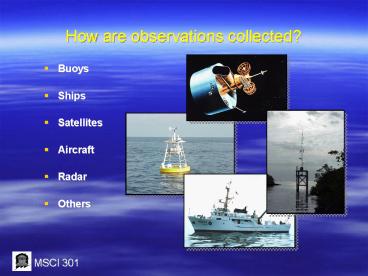
How are observations collected?
- Buoys
- Ships
- Satellites
- Aircraft
- Radar
- Others
2
There are many new instruments that help us
understand and observe the ocean around us
3
XBT CTD
4
(No Transcript)
5
Atlantic Temp
6
Eulerian
7
(No Transcript)
8
Acoustic Doppler Current Profiler
9
New technology in acoustics has enabled physical
oceanographers to use acoustic Doppler technology
to measure waves and currents and send the data
back to shore.
10
South Carolina Real-time ADCP data
- Springmaid Pier http//nautilus.baruch.sc.edu/wav
es/springmaid/index.php - Folly Beach http//nautilus.baruch.sc.edu/waves/f
olly/index.php - Buoys http//nautilus.baruch.sc.edu/waves/folly/i
ndex.php
11
Real-time data meteorological and oceanographic
data are available on the web
12
What are ocean observing systems?
- Continuous measurement and monitoring
- Long-term data collection and management
- Effective data delivery andcommunications
- Relevant analysis product development
13
What do ocean observations measure?
- Examples
- Physical Ocean Conditions
- temperature
- currents
- waves
- water level
- Atmospheric Conditions
- winds
- pressure
- fog
- Biological/Ecological Conditions
- nutrients
- contaminants
- benthic habitat
14
Autonomous Underwater Vehicles
- AUV (Glider) date from Onslow Bay, North
Carolina
15
How is observing data presented?
- Measurement Products
- data tables
- maps
- graphs
- charts
- Direct Observations
- satellite images
- photos
- Video
- Analyses
- climatologies
- trends
- comparative studies
16
How can ocean models add value to observations?
- Filling in the gaps - providing information for
areas not covered by direct measurements - Making predictions and providing short-term
forecasts - Combining various observation types to simulate
complex ocean dynamics
17
How does outreach contribute to successful
observing systems?
- Focus systems on providing practical applications
- Identify and assess user needs and data
preferences - Obtain user feedback on information and products
- Train users to use informationand products
- Contribute to needs-based scientific and
technical advances
18
What are practical observing system applications
for weather, climate, hazards?
- Hurricane coastal storm forecasts
- Flooding and storm surge response
- Coastal erosion prediction planning
- Rip current forecasts
- Marine wind and wave forecasts
- Search and rescue operations
- Toxic spill response
19
What are practical observing system applications
for marine industries?
- Commercial shipping
- Ocean engineering
- Commercial fishing
- Marine towing salvage
- Port operations
- Cruise lines operations
- Military operations
20
What are practical observing system applications
for public health?
- Shellfish closures
- Harmful algal blooms
- Water quality
- Beach closures
- Seafood contamination
- Stormwater impacts
- Pathogens
21
What are practical observing system applications
for coastal resource management?
- Fisheries management
- Endangered species
- Habitat degradation
- Invasive species
- Erosion management
- Coastal development
- Marine mammals
22
What are practical observing system applications
for coastal marine recreation?
- Recreational fishing
- Coastal tourism
- Boating sailing
- Surfing
- Diving snorkeling
- Charter tours
- Swimming
23
What are practical observing system applications
for commercial sectors?
- Energy exploration
- Insurance reinsurance
- Commercial weather providers
- Ocean industries
- Utilities planning
- Commercial ocean information providers
- Aquaculture
Image courtesy of Roffers Ocean Fishing
Forecasting Service
Image courtesy of WSI
24
Lagrangian
25
Tracks
26
Spills
27
Satellite Oceanography
28
Geostationary Orbit
29
Geostationary View
30
Global SST
31
- Waters Warm Enough to produce Hurricanes
32
Polar Orbit
33
Polar Orbiting
34
GS 2
35
- Geostationary - Low Resolution
- Polar Orbiting - High Resolution
Radiometer SST Measures emitted IR radiation
36
Katrina
- Radiometer
- Measures reflected visible radiation
37
Ocean Color - Chlorophyll
- Radiometer - measures chlorophyll
38
- Red Tide
39
Scatterometer Data
40
Hurricane Winds
41
Wave Height
42
Altimeter Data
43
(No Transcript)
44
Chlorophyy 2
45
- Loss of Sea Ice
46
(No Transcript)


