
U.S. Integrated Ocean Observing System (IOOS®) - PowerPoint PPT Presentation
1 / 30
Title:
U.S. Integrated Ocean Observing System (IOOS®)
Description:
U.S. Integrated Ocean Observing System (IOOS ) A tool that enables the Nation to track, predict, manage and adapt to changes in our marine environment and delivers ... – PowerPoint PPT presentation
Number of Views:81
Avg rating:3.0/5.0
Title: U.S. Integrated Ocean Observing System (IOOS®)
1
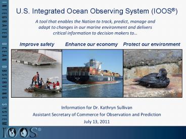
U.S. Integrated Ocean Observing System (IOOS)
A tool that enables the Nation to track, predict,
manage and adapt to changes in our marine
environment and delivers critical information to
decision makers to
- Information for Dr. Kathryn Sullivan
- Assistant Secretary of Commerce for Observation
and Prediction - July 13, 2011
2
U.S. IOOS Program Overview
- Codified in law (P.L. No 111-11, March 2009)
- Partnership effort that leverages dispersed
national investments to deliver ocean, coastal
and Great Lakes data relevant to decision-makers
- Enhances science and improves decision making
- Deepwater Horizon response
- Fukushima tsunami response products and services
- Climate predictions IPCC and National
Assessments - Integration of ocean observations included in a
National Ocean Policy priority objective
- Global Component
- Over 60 countries contribute satellite and in
situ networks - NOAA provides 50 of global in situ arrays
- 61 of the Global Climate Ocean Observing System
completed - Academia, governmental and industry partnerships
- Coastal Component
- 17 Federal agencies
- 13 regional partners
- Academia Industry
12
3
NOAAs Role
- Lead Federal Agency
- ICOOS Act of 2009 named NOAA as the lead federal
agency - US IOOS program office resides within NOS
- NOAA Contributions
- Observations and models distributed across NOAA
- OAR NESDIS lead US contributions to Global
Ocean Ob System - Data Management and Communications System
Architect - Coordinate federal and non-federal assets to
create a - robust national system
- Value to NOAA and the Nation
- Leverage the National investment in ocean
observations - Over 3,200 non-NOAA regional sensors
- Federal obs assets (e.g., USGS stream gauges
USACE wave buoys) - Leverage stakeholders to address societal
challenges
The value of interoperable ocean data to NOAA
alone is between 38 and 60 million dollars over
15 years - IOOS Business Case
4
U.S. IOOS History
- 1998 Reps Saxton and Weldon request NORLC
propose a plan to achieve a truly integrated
ocean observing system - 2000 Ocean.US established
- 2002 Airlie House interagency report provides
guidance for a sustained IOOS - 2006 First U.S. IOOS Development Plan
- 2007 IOOS in the Presidents Budget within NOAA
NOAA IOOS Program Office established - 2007 NOAA begins Data Integration Framework
project to inform U.S. IOOS development - 2008 NOAA IOOS delivers High Level Functional
Requirements and CONOPS for U.S. IOOS DMAC
subsystem - 2008 Ocean.US disestablished
- 2009 Integrated Coastal and Ocean Observation
System Act enacted (Public Law No. 111-11) - 2010 National Ocean Policy Priority
Objective 9 - 2010 US IOOS A Blueprint to Full Capability
v1.0 published Data Integration Framework
successfully completed DMAC v1.0 - 2011 NOAA IOOS Program Office recognized by
IOOC NFRA as US IOOS Program Office
5
U.S. IOOS Structure
GLOBAL COMPONENT
COASTAL COMPONENT
REGIONAL
NATIONAL
GLOBAL
National Federation of Regional Associations
(NFRA)
CEQ/OSTP National Ocean Council
WMO/IOC Joint Technical Commission for
Oceanography and Marine Meteorology (JCOMM)
Committee on Earth Observation Satellites
Ocean Science and Technology Interagency Policy
Committee
11 Regional Associations (RAs)/ Regional Ocean
Observing Systems 2 Functional Consortium
Group on Earth Observations (GEO)
IOC GOOS
Interagency Ocean Observation Committee
US IOOS Program Office
OAR/CPO/Climate Observation Division
NESDIS
Spans the Great Lakes Coastal to Global
Guidance Requirements
Capacity Capabilities
Leveraging existing NOAA-wide capabilities
Education
Research
Modeling Analysis
Data Management Communications (DMAC)
Observations
6
GOOS History
- OceanObs99 community input to Global Climate
Observing System (GCOS) Implementation Plan
(2004 refreshed 2010) - Initial Global Ocean Observing System baseline
- UNFCC Priority G8 Commitment
- Designed primarily to address climate
requirements, e.g. SST Surface Currents Sea
Level Sea Ice Ocean Carbon - Observations also support other needs, e.g.
weather prediction, ecosystems - Coordinated through WMO-IOC JCOMM
- NOAA OAR/CPO/COD responsible for the in-situ
NASA and NESDIS for satellite programs - Value of international partnerships NOAA
leverages over 50 of in situ assets worldwide
7
Global Component Global Ocean Observing System
for Climate
8
Earths Changing ClimateMotivating Developing
the Global Ocean Observing System
- Observing system is the foundation of climate
services - Monitoring and understanding ocean changes
- Sea level rise
- Ocean carbon sources and sinks
- The oceans storage and global transport of heat
and fresh water - The air-sea exchange of heat and fresh water
- Sea ice extent
- Impacts on marine ecosystems, acidification
- Predicting Change
- ENSO, MJO, monsoons, decadal and longer
variations, climate change,
9
Coastal Component
- Comprised of federal agencies (National level)
and non-federal (Regional level) - Geographic extent EEZ to the head of the tide
- Supports multiple societal benefits IOOS
Development Plan lists 7 - Based on 26 variables observation programs not
as well defined as in the Global component - Data Management and Communications (DMAC) is a
major focus that is intended to be enterprise
wide from National to Regional scales
10
U.S. IOOS Program Office
- Providing Programmatic Leadership by continuing
to build the structure and support necessary to
ensure progress in the implementation and
recognition of a functioning US IOOS - Fostering Operational Capability as the system
architect for the DMAC subsystem and selected
leadership and coordination roles within the
other subsystems - Forging robust partnerships between the Federal
agencies/institutes and the Regional IOOS
partners - Pres-Bud in FY091011 NOAA IOOS 6.5M Regional
Observations 14.5M
11
U.S. IOOS A Maturing National Program
- US IOOS Blueprint for Full Capability adopted by
Interagency Ocean Observation Committee (IOOC)
Partner Assessments ongoing as part of NOP
Strategic Action Plan 9. - Independent Cost Estimate is beginning
- Moved from legacy system of earmarks and
independent PIs to a national network of
integrated observations that is delivering - New observational capability
- Systematic data integration
- Benefits across many sectors
12
National Level
- Recognized Partnerships between US IOOS Program
Office and NOAA - NWS/NDBC observing assets and data management
- NOS/CO-OPS observing assets and data management
- NMFS/Science Center (Pacific Grove) data
management - Recognized Partnerships between US IOOS Program
Office and other Federal Partners - USACE
- Billet in the US IOOS Program Office
- Waves observing
- National Science Foundation Oceans
Observatories Initiative - Coordinated coastal observing seeking
co-development agreement for cyber infrastructure - National Water Quality Monitoring Network
(NOAAUSGSEPA) - National data management schema
- Regionally project with EPA for improved beach
water quality forecasting - Identifying additional Federal contributions
through the US IOOS Blue Print assessment process
13
Operational Partnerships Integrating IOOS
Data Multiple Delivery Methods
- National Data Buoy Center
- 76 of the coastal data to the GTS supplied by
NOS from IOOS, CO-OPS and NERRS - US IOOS Data Assembly Center (DAC)
- Integrating IOOS data into NOAAs PORTS
- Waves Chesapeake, San Francisco, Long Beach/Los
Angeles and Mouth of Columbia River (through MOU
with USACE PORTS) - Currents underway for NY/NJ harbor
- Methodology established that allows for other
sites to be incorporated
14
New Observations High Frequency Radar Network
- Stakeholders
- gt 30 institutions operate HF Radars represents
a Federal/State investment of 55M in last 15
years - Used by gt40 government/private entities
- Largest producer (80 of the world market) is
US-based CODAR Ocean Sensor - Value
- USCG Search and Rescue Oil spill response
- Water quality Criminal forensics
- Commercial marine navigation
- Offshore energy Harmful algal blooms
- Marine fisheries
- Emerging - Maritime Domain Awareness
- Risk
- Frequency Allocation
Decreases search area by 66 in 96 hours
15
Pathway to a National DMAC
Acquisition Track (Traditional)
Building DMAC with Partners
FY
08
FY 10
FY 11
FY 12-14
FY 09
16
U.S. IOOS Regional Component
IOOS Regional Component Focused on Marine
Operations Coastal Hazards Climate Variability
Change Ecosystems, Fisheries, Water
Quality Supports CMSP Regionally based 3D,
dynamic data
- Comprised of State, Local, Tribal governments
Academia Private Sector - Governance 501C3 or MOU
- Meeting National missions through
- Expanded observations and modeling capacity
- Connections to users and stakeholders
- Implementation of national data standards
- Products transitioned to other regions and to
National operations
17
U.S. IOOS Regional Component (cont)
- Alliance for Coastal Technologies (ACT)
- Sensor Validation and Verification
- US IOOS Modeling Testbed
- Led by Southeastern University Research
Association (SURA) - A consortium of over 60 universities
- Operates the Thomas Jefferson National
Accelerator Facility for the U.S. Department of
Energy through Jefferson Science Associates - a
SURA/Computer Sciences Corporation joint venture
18
Selected Products Marine Coastal
NWS portal based on IOOS Regional Project
Reducing Distress Calls
Harmful Algal Bloom
19
Selected Products Climate Variability Change
Ocean Acidification Partnership with shellfish
growers
Observations Single system multiple uses - NOAA
PMEL working with RAs to deploy CO2 sensors
of living coral Puerto Rico
Validating Sensors
Integrated Coral Reef Monitoring
20
Selected Products Ecosystems, Fisheries Water
Quality
Ocean Obs to understand larval transport
Gliders Dissolved Oxygen water quality
monitoring
21
Responding to Crisis Deepwater Horizon
- U.S. IOOS partnership demonstrated ability to
- Quickly deploy technologies Gliders and HF
radar, saving resources/improving safety - Models/Imagery ingested into NOAA/Navy models
- Data assimilation improved spill response
decision-making and public understanding
USM HFR
TS Bonnie
USF HFR
HFR validation of SABGOM Forecast with satellite
detected oil slicks
Briefing Blog
Web Portal
22
Responding to Crisis Japan Tsunami Response
- CeNCOOS
- Recorded the tsunami passage with U.S. IOOS
sensors - Five-fold increase in web traffic
- NANOOS
- Featured Tsunami Evacuation Zones for the Oregon
Coast application - NANOOS Visualization System provided easy access
to current and water height data - Four-fold increase in web traffic
- PacIOOS
- Provided the only real-time water level and
turbidity measurements for Waikiki - Ten-fold increase in web traffic
23
U.S. IOOS Coastal Ocean Ecosystem Modeling
Testbed
- FY10 4M Programmatic Language(Senate)
- FY11 975K Recommended
- 5 teams, 64 scientists/analysts
- SURA is overall lead for execution
- One year project (May 2010-11) no-cost
extension to Dec 2011 - Multi-sector engagement (federal agency,
academia, industry) - Goals
- Less about model than process
- Focus is on stable infrastructure (testing
environment, tools, standard obs) and transition
to operations - Enable Modeling and Analysis subsystem
24
U.S. IOOS Education
- Promote Regional Activity
25
OOI Research and Development Component
Programs linked through coordinated observation
shared development of DMAC
26
U.S. IOOS Highly Leveraged/Interdependent
NANOOS awarded funds for this buoy array through
the Murdock Foundation because of the IOOS
infrastructure in place and NANOOS ability to
provide OM
IOOS provides the backbone others can take
advantage of the network
27
Industry Participation
- Observing Subsystem
- Largest producer (80 of the world market) of HF
radar is US-based CODAR Ocean Sensor In part
because of the US lead on fielding an HF Radar
network, CODAR Ocean Sensors exports to gt20
countries - Only commercial producers of gliders are US
companies (Teledyne Webb Research Inc.
I-robot) - Wave Gliders produced by a US company Liquid
Robotics - DMAC Subsystem
- 4 IOOS Regions partner with industry to provide
DMAC capability - Modeling and Analysis Subsystem
- 2 industries associated with test bed
- Partnerships
- MOU with Shell
- Value-Added Companies
- Surfline ROFFS Weatherflow 43 non federal
entities using HF Radar
28
Programmatic Shift
28
29
Operational Shift
29
30
U.S. IOOS A National Endeavor
- IOOS is a comprehensive system
- Integration of data is critical
- Sustaining the enterprise requires engagement by
all of us - Near-term matters
- Congressional Report at NOC-IPC
- Congressional Request for a Cooperative Institute
for Sensor VV - Seating of the IOOS Federal Advisory Committee
Recommended
CrystalGraphics Presentations


