
Usarray PowerPoint PPT Presentations
All Time
Recommended

Current Status of USArray and EarthScope
| PowerPoint PPT presentation | free to view
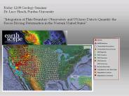
Friday 12:00 Geology Seminar Dr. Lucy Flesch, Purdue University Integration of Plate Boundary Observatory and USArray Data to Quantify the Forces Driving ...
| PowerPoint PPT presentation | free to download

Seismicity (ANSS) Paleoseismology. Local site effects. Faults (USArray) Stress transfer ... Seismic velocity (USArray) (from Leinen, 2004) ...
| PowerPoint PPT presentation | free to view

Users utilizing Antelope for analysis and archiving with DMS. PIC is using Antelope for real-time pier and bench testing, vault tests, and USArray. ...
| PowerPoint PPT presentation | free to view

Luke Zoet-Penn State University-2nd Year PhD Student-Using Passive Seismic Data to Better Understand the Subglacial Mechanics Responsible for Glacial Flow
| PowerPoint PPT presentation | free to download
Title: PowerPoint Presentation Author: mike ritzwoller Last modified by: mike ritzwoller Created Date: 9/7/2006 10:14:40 PM Document presentation format
| PowerPoint PPT presentation | free to download

Title: PowerPoint Presentation Author: David Simpson Last modified by: Kaye Shedlock Created Date: 10/30/2002 10:01:35 PM Document presentation format
| PowerPoint PPT presentation | free to view
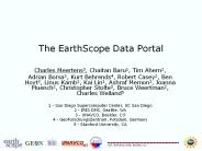
... Schema of the EarthScope Data Portal request available at http://schemas.earthscope.org/portal/0.4/esdp.wsdl Portal will provide ability to add datasets to a ...
| PowerPoint PPT presentation | free to download

Application of empirical Green s functions for the construction and validation of the GBCVM Morgan P. Moschetti and Michael H. Ritzwoller Center for Imaging the ...
| PowerPoint PPT presentation | free to view

Monitoring Earthquakes in the U'S' Midcontinent:
| PowerPoint PPT presentation | free to download
Seismogram analysis in two parts: Utah Mine Collapse. Analysis 1: ... The model seismogram should align as closely as possible with the data. Utah Mine Collapse ...
| PowerPoint PPT presentation | free to download

Kinematics and Dynamics of Western U' S' Deformation
| PowerPoint PPT presentation | free to view

Title: Automatic determination of earthquake focal depth (and focal mechanism?) using cepstral analysis and SOD (?) Author: Chin-Wu Chen Last modified by
| PowerPoint PPT presentation | free to download

Earth Science Applications of Space Based Geodesy DES-7355 Tu-Th 9:40-11:05 Seminar Room in 3892 Central Ave. (Long building) Bob Smalley
| PowerPoint PPT presentation | free to download

CISN: California Integrated Seismic Network The Program Management Group (PMG): Tony Shakal CGS David Oppenheimer USGS Menlo Park Peggy Hellweg & Doug ...
| PowerPoint PPT presentation | free to download

Earths Deep Water Cycle
| PowerPoint PPT presentation | free to view
... server (provides links to DP webserver) Digitizes sensor and ... cycled DP & data storage ... The baler (DP) queries the Q330 for FIR filter delays and ...
| PowerPoint PPT presentation | free to download

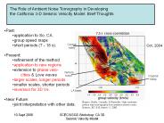
High Resolution Surface Wave Tomography from Ambient Seismic Noise
| PowerPoint PPT presentation | free to download

7-1 Forces in Earth s Crust 7-3 Monitoring Earthquakes Monitoring Earthquakes Earthquake Risk The map shows areas where serious earthquakes are likely to occur ...
| PowerPoint PPT presentation | free to download

More Data Center Tools Rick Benson IRIS DMC
| PowerPoint PPT presentation | free to download

... -agency crisis management demo 28 August 2001 DARPA ENCOMPASS Server at SSC 64kbps ISDN link Inmarsat ground station Inmarsat satellite Sharp Hospital relay ...
| PowerPoint PPT presentation | free to download

12'540 Principles of the Global Positioning System Lecture 23
| PowerPoint PPT presentation | free to download

An interdisciplinary collaboration for research and infrastructure
| PowerPoint PPT presentation | free to view

P waves are compressional waves, just like sound waves. Along the paths traveled by P or sound waves the ground compresses and dilates. ...
| PowerPoint PPT presentation | free to view

| PowerPoint PPT presentation | free to view

Data Management Practices and Challenges in Geosciences Today
| PowerPoint PPT presentation | free to view

Thailand Earthquake
| PowerPoint PPT presentation | free to download


0 1 2 3 4 5 6 7 8 9 : ; = ?A B C D E F G H I J K L M N O P Q R S T U V W X Y ... B BFBFJF 0*dVWQ :FFBNNJ OOsGG RRQCB KJFusm :6n 52.eFpQJBJFBaOs YRM qhbC; ...
| PowerPoint PPT presentation | free to view

... filled with rubble, and parked cars were crushed under large blocks of ... AP Photo/Pier Paolo Cito. Before and After Photos. Magnitude 6.3 CENTRAL ITALY ...
| PowerPoint PPT presentation | free to view

... 1999/02/22-rdf-syntax-ns#' xmlns:iX='http://ns.adobe.com/iX/1.0 ... xmlns:pdf='http://ns.adobe.com/pdf/1.3/' /rdf:Description rdf:Description rdf:about ...
| PowerPoint PPT presentation | free to download
Enter Slide Titles Here
| PowerPoint PPT presentation | free to download

Portable Broadband Seismology Part 3 ... Drawing Microsoft Equation Portable Broadband Seismology Modern Seismic Technology Q330 Data Engine Overview of ...
| PowerPoint PPT presentation | free to view

Portable Broadband Seismology
| PowerPoint PPT presentation | free to download
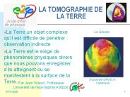
LA TOMOGRAPHIE DE LA TERRE La Terre un objet complexe qu il est difficile de p n trer : observation indirecte La Terre est le si ge de ph nom nes physiques ...
| PowerPoint PPT presentation | free to download

Data Loggers and Sensors
| PowerPoint PPT presentation | free to view

Kyle Bohnenstiehl
| PowerPoint PPT presentation | free to view

efxfeGbcdefghijklmnopqrstuvwGa kGaa aLShGiGjGs ISJSKS*Fp q r 9T*FhO8TNeOfO ... 7CvwbHag6Z577aa7Ngy4zjNek9B3udo8xhsCwLzx5L1K1tXuJrf63b20hkTUoApk9I7/AL FeG6 d ...
| PowerPoint PPT presentation | free to download

Art Lerner-Lam (Lamont-Doherty Earth Observatory & IRIS) ... Waveforms or picks & snippets. products. Integrated Processing Service. continuous? Info outlet ...
| PowerPoint PPT presentation | free to view
Portable Broadband Seismology
| PowerPoint PPT presentation | free to download

The EarthScope Facility: A new experiment in cooperative solid earth science
| PowerPoint PPT presentation | free to view

Using NLR. Lambdas Provide Global Access. to Large Data Objects and Remote Instruments ... Have Been Extended to Apple-Based Systems 'iWall Driven by iCluster' ...
| PowerPoint PPT presentation | free to download

Neurosciences. High Energy Physics ... Domain-specific Cybertools (software) Shared ... Authentication - Authorization - Auditing - Workflows - Visualization ...
| PowerPoint PPT presentation | free to view

NIH's Biomedical Informatics Research Network. Common Needs ... Biomedical Informatics. Research Network (BIRN) NIH Plans to Expand. to Other Organs ...
| PowerPoint PPT presentation | free to view

Fluids and Faulting:
| PowerPoint PPT presentation | free to view

High Resolution Surface Wave Tomography from Ambient Seismic Noise
| PowerPoint PPT presentation | free to view

The views and conclusions contained in this document are ... Location: Windless Bight, Antarctica. Latitude: -77.7400. Longitude: 167.590. Elevation: 0.041 km ...
| PowerPoint PPT presentation | free to view

SAGE Rio Grande Rift, New Mexico. Three-Dimensional MT. Pacific Northwest, USA ... of the Santo Domingo Basin, Rio Grande rift, New Mexico, M. S thesis, San ...
| PowerPoint PPT presentation | free to view


Directorate for Geosciences
| PowerPoint PPT presentation | free to view

Why the Geological Sciences Need Cyberinfrastructure Geoinformatics The view of a working class geop
| PowerPoint PPT presentation | free to view

P ''a GpSs tFTOdfe n * F*AJClc L ... 5W/mUUAHlyf7a H/emw7OD/wAtGMvaHTEc5fJZ 1WjI5y5jp5qn/Kr/wAyf pdm ...
| PowerPoint PPT presentation | free to download


The earthquake-forecast model applied in the National Hazard maps uses a time ... (1) To develop and test a range of viable earthquake-potential models ...
| PowerPoint PPT presentation | free to view

Structure and Properties of the San Andreas Fault at Seismogenic Depths: Recent Results from the SAF
| PowerPoint PPT presentation | free to view