
Gis Mapping Software PowerPoint PPT Presentations
All Time
Recommended

GIS Overview: Management of GIS Projects, GIS at the City of Seattle and GIS Careers
| PowerPoint PPT presentation | free to view

COM is a protocol that connects one software component with another. ... library. The library provides a complete .NET functions to allow .NET program to access a ...
| PowerPoint PPT presentation | free to view

... 4 hours IDHS Support Library of ESRI Licenses WebEOC Flexviewers Specialized GIS skills Funding How our DRTF will be Organized 3-5 credentialed members ...
| PowerPoint PPT presentation | free to download

Best GIS Software - comparing 41 companies across 99 criteria. Read unbiased reviews, insights and compare features. View top GIS Softwares listed by 360quadrants.
| PowerPoint PPT presentation | free to download

GIS in Action Getting Started With GIS Chapter 9 9 GIS in Action 9.1 Introducing GIS in Action 9.2 Case Study 1: GIS Fights the Gypsy Moth 9.3 Case Study 2: GIS and ...
| PowerPoint PPT presentation | free to view
GIS Analysts play a crucial role in analyzing and visualizing geographic data to solve real-world problems. They use Geographic Information System (GIS) tools to map trends, optimize logistics, and support decision-making in urban planning, environmental management, and disaster response. With expertise in spatial analysis, GIS Analysts transform raw data into actionable insights, helping industries and governments make informed choices.
| PowerPoint PPT presentation | free to download

Indshine’s GIS software is designed to store, manage and analyze all forms of geographical and spatial data. You can produce maps and other graphic displays of geographical information using Indshine’s GIS software for comprehensive analysis and presentation. Get to know more about GIS software here.
| PowerPoint PPT presentation | free to download

GIS Brown. Bag Lunch. GIS Software. Chris Gist. Geostat Center. Alderman Library ... GIS Brown. Bag Lunch. Manifold GIS. http://www.manifold.net/ Fully ...
| PowerPoint PPT presentation | free to view

United States. Inyo County. City of Bishop. 3D Representations. Registration. Overlaying ... It is a photographic map in which ground features are displayed in ...
| PowerPoint PPT presentation | free to view

Faith Based GIS Using GIS to
| PowerPoint PPT presentation | free to view

GIS AND CENSUS MAPPING IN ST' LUCIA
| PowerPoint PPT presentation | free to download

Data for institutional services was captured and Namplan dataset was ... A constituency with two urban centers will have 01' for the ... New GIS ...
| PowerPoint PPT presentation | free to download

Software Options for Operational GIS in Professional Environment Free
| PowerPoint PPT presentation | free to view

Software Options for Operational GIS in Professional Environment Free
| PowerPoint PPT presentation | free to view

What is this GIS stuff? GIS at UD: Geographic ... create. modify. data. ... Can download raw data from here, open it up in Excel, save as dBaseIV file and ...
| PowerPoint PPT presentation | free to view

A geographical information system is composed of 5 elements: ... Map-based query & analysis. Compose maps for printing or publishing. 12/20/09 ...
| PowerPoint PPT presentation | free to view

Geographic information system is much more than a map in a computer ... It is not a program that can just display maps, like a street atlas program ...
| PowerPoint PPT presentation | free to view

Geographic information system (GIS) is a computerized tool that helps in gathering, managing, and analysing spatial and geographic data. A geographic information system (GIS) is a conceptualized framework that integrates different types of data into visualizations using maps and 3D techniques. https://www.databridgemarketresearch.com/reports/global-geographic-information-system-gis-software-market
| PowerPoint PPT presentation | free to download

GIS Mapping for Utilities Jessica Lillie Why your utility needs GIS NOW!!! How does your system keep track of its underground utilities? As-builts and blue prints ...
| PowerPoint PPT presentation | free to view

Geographic information system (GIS) is a computerized tool that helps in gathering, managing, and analysing spatial and geographic data. A geographic information system (GIS) is a conceptualized framework that integrates different types of data into visualizations using maps and 3D techniques.
| PowerPoint PPT presentation | free to download

Development of Census Mapping and Use of GIS in China
| PowerPoint PPT presentation | free to download

Web-based and Mobile GIS for High School GIS Career Awareness. by Dr. Ming-Hsiang (Ming) Tsou ... Barnacle (Boat Channel Study: HTH Biotech Website) Flatworm ...
| PowerPoint PPT presentation | free to download

GIS-Assisted Approach in Soil Erosion ... widely known as USLE. Erosive power of rainfall (R) Soil erodibility (K) Topographic ... Generation of Input Maps ...
| PowerPoint PPT presentation | free to view

License Must Not Restrict Other Software 10. ... gvSIG, QGIS, OSSIM ArcINFO/ArcGRID analysis - GRASS, OSSIM, SEXTANTE ArcPad ... ISU-ISU SEMAKN Author:
| PowerPoint PPT presentation | free to download

GIS in K-12: why, how, and when to use GIS in Education Presented by Jung Lee, Ph. D Richard Stockton College of NJ leej@loki.stockton.edu April 16, 2001
| PowerPoint PPT presentation | free to download

Major focus on utilizing best available data to make best maps possible ... Live entertainment, good food and refreshing beverages. PaMAGIC Board Election ...
| PowerPoint PPT presentation | free to view

Geographic Information System (GIS) is a computer based system which integrates software and hardware in order to collect, manage, analyse all sorts of spatial or geographical data. GIS has wide applications in various sectors such as agriculture, oil & gas, construction, mining, transportation, utilities and others. GIS is mainly used to create maps of those locations which are not easily reachable such as different layers of Earth’s Crust.
| PowerPoint PPT presentation | free to download

Many of the villages do not figure in district/revenue maps ... fuel distribution points to the GIS map to help in grid extension vs renewable ...
| PowerPoint PPT presentation | free to view

University of California Riverside. GIS: Transform and Enhance Social Research ... Map shows spatial relationship among the states ...
| PowerPoint PPT presentation | free to download

GIS is a hybrid between traditional database management software and traditional cartographicCompute
| PowerPoint PPT presentation | free to view

SDFRN Workshop April 13, 2005, San Diego Natural History Museum Combining Web-based GIS and Wireless Mobile GIS for Wildfire Recovery and Watershed Management
| PowerPoint PPT presentation | free to download

ESRI's ArcIMS development environment for creating interactive Web maps ... Private geospatial data (ADC Digital Maps, AWS meteorological data) City 1. City 2. City n ...
| PowerPoint PPT presentation | free to view

Geographic information system (GIS) is a computerized tool that helps in gathering, managing, and analysing spatial and geographic data. A geographic information system (GIS) is a conceptualized framework that integrates different types of data into visualizations using maps and 3D techniques.
| PowerPoint PPT presentation | free to download

Technical possibilities estabilished by WETLIVONIA for remote sensing, GIS and ... ERDAS IMAGINE , from Leica Geosystems Geospatial Imaging, is the leading imagery ...
| PowerPoint PPT presentation | free to view

GIS with spatial intelligence includes map literacy, the ability to transform ... map Europe.tab by Tino Johansson 2004. IGU 19.08.2004. ...
| PowerPoint PPT presentation | free to view

Global GIS software market is projecting a rise in estimated value to an estimated value of USD 13.95 billion by 2026, registering a healthy CAGR of 10.1% in the forecast period of 2019-2026 due to Rising investment in GIS solutions, Projects related to development of smart cities and Adoption of GIS solutions in various sectors
| PowerPoint PPT presentation | free to download

Title: Discovery of software systems for composition and their customizability in free and open source geospatial software environments A Case Study
| PowerPoint PPT presentation | free to download

University of California Riverside. GIS: Transform and Enhance Social Research ... Multiple Sources linked on a single map: City of New Orleans and Katrina ...
| PowerPoint PPT presentation | free to view

Introduction to GIS, Thematic Mapping, and Spatial Analysis in Social Science: Research, Teaching and Outreach Robert Nash Parker Presley Center for Crime and Justice ...
| PowerPoint PPT presentation | free to view

... definitions which is represented completely rigorous and unambiguous fashion. ... Trade Magazines: GIS World; Books with vendor information: ESRI Inc. ...
| PowerPoint PPT presentation | free to view

GIS is primarily 2-D. Time and height handled as attributes, not as part of the database ... SIMS Shellfish Information Management System (NOS) Using Java 3D ...
| PowerPoint PPT presentation | free to view

Use was mainly in the public sector. Has roots in cartography and mapping ... ESRI defines GIS as: A collection of computer hardware, software, and geographic ...
| PowerPoint PPT presentation | free to view
Outline. GIS overview. GIS data and layers. GIS applications and examples. Software overview. GIS tutorial 1 overview. GIS TUTORIAL 1 - Basic Workbook
| PowerPoint PPT presentation | free to download
How to Pick a GIS Getting Started With GIS Chapter 8 8 How to Pick a GIS 8.1 The Evolution of GIS Software 8.2 GIS and Operating Systems 8.3 GIS Software Capabilities ...
| PowerPoint PPT presentation | free to download
Geographic Information System (GIS) mapping and surveying is the use of GIS technology to collect, manage, analyze, and visualize spatial data. This data can be used to create maps, charts, and other visualizations that can help people understand and make decisions about the world around them.
| PowerPoint PPT presentation | free to download

GIS Geographic Information System Cluster 1 CPAS What is GIS? Geographic Information System (GIS) is a system of computer hardware, software, and procedures designed ...
| PowerPoint PPT presentation | free to download

What is GIS? Geographic Information Systems (GIS) are computerized systems designed for the storage, retrieval and analysis of geographically referenced data
| PowerPoint PPT presentation | free to view
Map audiences. Map use: Exploration Presentation. Audience:Trained analyst General public. Purpose:Visual thinking Communication. Advantages:Graphical Believable
| PowerPoint PPT presentation | free to download
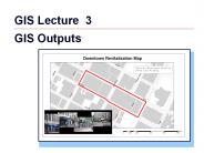
GIS Outputs Outline Map Design Principles Map Audiences Map Layouts Scales Multiple Maps Reports and Graphs on a Layout Exporting Maps Other Map Outputs Map Design ...
| PowerPoint PPT presentation | free to download

... City's limits and includes all of the water, sewer, and storm water utilities. ... Windows Based Server. GIS Filing Systems. Software Used ...
| PowerPoint PPT presentation | free to download

Introduction to GIS
| PowerPoint PPT presentation | free to view

Topics to be Covered. An overview of GIS history, definitions. What ... Logistics (Fed Ex, DHL, etc.) 33 'Learning is not compulsory...neither is survival. ...
| PowerPoint PPT presentation | free to view

GIS Tutorial 1 Lecture 3 GIS outputs * Granularity can be more classifications Course fewer classifications and bright colored hooks are needed ...
| PowerPoint PPT presentation | free to view

UPSTREAM GIS. Kirk A. Barrell. THE PETROLEUM PROCESS. LAND / LEASE. RETAIL. EXPLORATION ... EXPLORATION. BASE MAPS. BASIN ANALYSIS. TREND ANALYSIS. REGIONAL ...
| PowerPoint PPT presentation | free to view

Managing GIS Longley Ch. 17 Information Sources Tomlinson, Roger Thinking about GIS: GIS Planning for Managers ESRI Press, 2003 Zeiler, M. Modeling our World: The ...
| PowerPoint PPT presentation | free to download