
Geoname PowerPoint PPT Presentations
All Time
Recommended

GeoName: a system for back-transliterating. pinyin place names. Kui-Lam Kwok & Qiang Deng ... Wade-Giles: ? - hsiang, ? - kang. Hong Kong: ? - hong, ? - kong ...
| PowerPoint PPT presentation | free to view
LEC Power Translator. Hagen (1st monolingual German) GIRSA (GIR by semantic annotation) ... SINTRAM (Sinai Translation Module) Location index (Ling Pipe for NER ...
| PowerPoint PPT presentation | free to download

Query Rewriting Framework for Spatial ... should not be burdened with knowing how the ontology is structured Words which express semantic relations between ...
| PowerPoint PPT presentation | free to view
Temporal and Geographic Context for Digital Books
| PowerPoint PPT presentation | free to download
Visualization of Heterogeneous Data. Mike Cammarano. Xin (Luna) Dong. Bryan Chan. Jeff Klingner ... caption = This [[daguerreotype]] of Poe was taken in 1848 ...
| PowerPoint PPT presentation | free to download
Logics for Data and Knowledge Representation Resource Description Framework (RDF) Feroz Farazi RDF A language for representing Web resources and information about ...
| PowerPoint PPT presentation | free to download

19th Century numerous scientific and exploration expeditions ... Ensures uniformity in geographic nomenclature and orthography throughout the Federal government ...
| PowerPoint PPT presentation | free to download

Tables to Linked Data Zareen Syed, Tim Finin, Varish Mulwad and Anupam Joshi University of Maryland, Baltimore County 0 http://ebiquity.umbc.edu/paper/html/id/474/
| PowerPoint PPT presentation | free to download
A Mashup is a way of combining related data into a pictorial form using Socially Rich computing technology to make the data easy to read and understand Charts Graphs ...
| PowerPoint PPT presentation | free to download

BASIC CREATION OF NAME AND TITLE AUTHORITIES Module 1: Introduction *
| PowerPoint PPT presentation | free to download

Edinburgh DataShare A DSpace Data Repository: Achievements and Aspirations Stuart Macdonald EDINA National Data Centre & Edinburgh University Data Library
| PowerPoint PPT presentation | free to view

Official source for geographic names on Federal products depicting areas under ... Provides unique feature identifier, official name, and official location ...
| PowerPoint PPT presentation | free to download

The Fifth China - U.S. Roundtable on Scientific Data Cooperation Global Science Needs Global Data A Case for Data Sharing E. Lynn Usery usery@usgs.gov
| PowerPoint PPT presentation | free to download

... Institute of Geodesy, Cartography and Remote Sensing under the project 'Areial ... GEODESY - ECONOMICS INFORMATICS 2006. 7. Database of towers and high buildings ...
| PowerPoint PPT presentation | free to view
CJK NACO Webinar Series Supplement to the PCC NACO Training . Describing Places ... Group Two: Amusement parks, bridges, farms, forests, gardens, plazas, etc.
| PowerPoint PPT presentation | free to download

hives, itchy rash. red, itchy or swollen eyes. ears stuffed ... eczema, stomach pain, headaches, hives, flushing, itching. nausea, vomiting, cramps, diarrhea ...
| PowerPoint PPT presentation | free to view

Natural history museum collections (many in distributed databases) ... Locality description too vague, misspelled, unreadable handwriting, etc. ...
| PowerPoint PPT presentation | free to view

news, photos, blogs. KML - storage. GPX - data. GPS tracks, waypoints. Microformats ... title Grand Rapids WiFi: News, Updated Hotspot Locations, and Comments /title ...
| PowerPoint PPT presentation | free to view
Using Metadata in CONTENTdm Diana Brooking and Allen Maberry Metadata Implementation Group, Univ. of Washington Crossing Organizational Boundaries
| PowerPoint PPT presentation | free to download
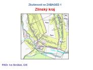
Zku enosti se ZABAGED 1 Zl nsk kraj RNDr. Ivo Skr ek, GIS ZABAGED 1 ZABAGED 1 form t ZABAGED 1 p klad vizualizace ZABAGED 1 p klad ...
| PowerPoint PPT presentation | free to download
Creating and Exploiting a Web of Semantic Data Tim Finin University of Maryland, Baltimore County joint work with Zareen Syed (UMBC) and colleagues at the Johns ...
| PowerPoint PPT presentation | free to download

Geographic names are a key component of the National Spatial Data Infrastructure ... Base theme of The National Map. Authoritative A16 database for geographic names ...
| PowerPoint PPT presentation | free to download

UK and Republic of Ireland: always abbreviate 'St.' and 'Mt.' Canada: follow ... Consult Z1 yellow pages, 667 field. 26. 667 subject usage field is optional ...
| PowerPoint PPT presentation | free to view

Knowledge can be interlinked. A knowledge base on one server. can refer to concepts from another knowledge base on another server. 'resource' (= 'entity' ...
| PowerPoint PPT presentation | free to download
Wikitology Wikipedia as an Ontology Tim Finin, UMBC Zareen Syed and Anupam Joshi University of Maryland, Baltimore County James Mayfield, Paul McNamee and Christine ...
| PowerPoint PPT presentation | free to download

ALCTS AACR2 2002 and Metadata Institute. Ready to Wear Metadata ... LITA National Forum 2003 Putting Technology into Practice. Modus Operandi. Cataloging ...
| PowerPoint PPT presentation | free to view

http://www.cs.vu.nl/~pmika/swc/btc.html. Analysis ... Degree of interconnectedness (percentage of non-literal statements, with/without ...
| PowerPoint PPT presentation | free to view
Hospitals. Post Offices. Libraries. Schools. Churches. Manmade Features ... Use Tribal Leaders Directory. Provides current Tribal addresses and phone numbers ...
| PowerPoint PPT presentation | free to download
Rich Internet Applications 5. Ajax and services Proxy example data exchange Rich Internet Applications 5. Ajax and services #* Browser - Server Server - Service ...
| PowerPoint PPT presentation | free to download
Build your own MapQuest! Adding Spatial Smarts to PostgreSQL with PostGIS. Paul Ramsey ... Write Map File ... MapQuest is an example of excellent cartography. ...
| PowerPoint PPT presentation | free to download

OpenCyc Commonsense AI Tutorial * STEPHEN L. REED PRINCIPAL DEVELOPER TEXAI.ORG Austin, Texas Topic Map Top Level Learn proper nouns logic Assignment ...
| PowerPoint PPT presentation | free to download
Creating and Exploiting a Web of Semantic Data * * * * * * * * * * * * The Wikitology KB was constructed by integrating information from three sources: Wikipedia ...
| PowerPoint PPT presentation | free to download

Next Generation Semantic Web Applications
| PowerPoint PPT presentation | free to download

Authorized term Unauthorized term. Card catalog see ref. Catalog ... Divinity and experience : the religion of the Dinka. Dinka (African people) from LCSH: ...
| PowerPoint PPT presentation | free to view

Drying - early Romans, Native Americans. Salted, cured & then nitrates to keep color ... Clarence Birdseye - late 1800's-quick freezing. Preserving Food ...
| PowerPoint PPT presentation | free to view

Lake Tahoe. Discussion of approach to resolving issues regarding 'duplicates' ... Half Moon Lake. Gazetteer 'Duplicates' Discussion (4) Specifics. Textual ...
| PowerPoint PPT presentation | free to view

English immigrants came to Canada in three different periods ... Nova Scotia, St. John River Valley of New Brunswick, in Quebec, and near Niagara. ...
| PowerPoint PPT presentation | free to view

CODI-GEO, SDI Seminar, Sept. 2001. Thank you to Rick Pearsall (FGDC) for ... Liz Gavin, Elmi Noppe, Antony Cooper, ISO TC211 Standards in Action Workshop, ...
| PowerPoint PPT presentation | free to view

Homeland Security
| PowerPoint PPT presentation | free to view

Coastal Atlas Interoperability Ontologies
| PowerPoint PPT presentation | free to download


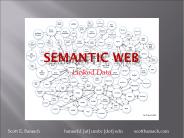
Introduction to the Semantic Web tutorial Johnson
| PowerPoint PPT presentation | free to view

'An extension of the current Web in which information is given well-defined ... MusicalManifestation (Record, Track, Playlist, etc.), MusicalItem (Stream, ...
| PowerPoint PPT presentation | free to view

Map & database publishing. Surveying & mapping. Public health ... MapQuest. Commercial: Tele Atlas Geography Network (formerly Etak) Delorme Street Atlas ...
| PowerPoint PPT presentation | free to view

CrossLanguage Evaluation Forum: Objectives and Achievements
| PowerPoint PPT presentation | free to download

Title: Slide 1 Author: w2k-Mosis-User Last modified by: Rick Block Created Date: 4/11/2006 4:01:08 PM Document presentation format: On-screen Show Company
| PowerPoint PPT presentation | free to download

U.S. Department of the Interior. State Partnerships and the ... Geographic Names Yawn! 12. GNIS Revolution Past Two Years. Completely redesigned database ...
| PowerPoint PPT presentation | free to view

Enhanced Programmer Toolkit - new presentation independent ... provides point geometry for Postal Codes by 3-digit Forward Sortation Areas (FSA) in GML 3.0.0 ...
| PowerPoint PPT presentation | free to view

Global Positioning System LUCID Summer Workshop July 29, 2004 Background In the past, humans had to go to pretty extreme measures to keep from getting lost.
| PowerPoint PPT presentation | free to view

Identifying Attributes for Named Physical and Cultural Geographic Features ... Supersedes ... GNIS Feature ID superseded FIPS 55 Place Code as federal standard ...
| PowerPoint PPT presentation | free to view

Research in Semantic Web and Information Retrieval: Trust, Sensors, and Search T. K. Prasad (Krishnaprasad Thirunarayan) Professor Kno.e.sis Center
| PowerPoint PPT presentation | free to view

... map series equivalency. Generally excludes: urban features, street. numbered ... Local ... Area-Specific Policies and Procedures. Staff country policies. Linguistic ...
| PowerPoint PPT presentation | free to view

... orbit by riding on a rocket or by riding in the cargo bay of the Space Shuttle. ... telemetry; tracking, and control (TTC); propulsion; attitude ...
| PowerPoint PPT presentation | free to view

Title: Part II Author: Library Systems Office Last modified by: Rick Block Created Date: 6/12/2002 5:12:54 PM Document presentation format: On-screen Show
| PowerPoint PPT presentation | free to download

WFS contains attributes and therefore can contain more information than other OGC services. ... WFS valuable to users but requires more time to process the data. ...
| PowerPoint PPT presentation | free to view

Names were assigned based on the most prevalent name within a basin (based on ... Developed by the USGS in cooperation with the U.S. Board on Geographic Names ...
| PowerPoint PPT presentation | free to download