
Measuring the Earths Dimensions - PowerPoint PPT Presentation
1 / 22
Title:
Measuring the Earths Dimensions
Description:
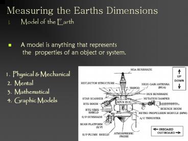
Measuring the Earths Dimensions Model of the Earth A model is anything that represents the properties of an object or system. 1. Physical & Mechanical – PowerPoint PPT presentation
Number of Views:164
Avg rating:3.0/5.0
Title: Measuring the Earths Dimensions
1
Measuring the Earths Dimensions
- Model of the Earth
- A model is anything that represents
- the properties of an object or system.
1. Physical Mechanical 2. Mental
3. Mathematical 4. Graphic Models
2
- II. The shape of the earth
- A. Observations that the earth is curved.
- 1. Ships at Sea
- 2. Eclipses
- 3. Photographs from space are the best examples
proving the earth is round.
3
- The earth is an oblate spheroid or a NEARLY
PERFECT CIRCLE - B. The circumference measured between the poles
the equator are different. - 1. Slightly flat at the poles and bulging at
the equator - 2. Gravity meters tell us so
- Gravity Stronger at the poles.
- Equatorial Diameter 12,756 km
- Polar Diameter 12,714 km
4
- C. Observations of Polaris lead to the conclusion
that the earth is round. - Parallelism The north pole points to Polaris.
- The Altitude of Polaris Equals Your Latitude
- Altitude is an angle measured from the horizon.
- Horizon is where the sky touches the earth.
- Zenith straight above your head.
5
- Altitude of Polaris is Equal To Your Latitude
- Latitude
- 42 ? North Latitude
6
- At the equator your
- altitude to Polaris is 0 ?
- In New York the Average
- Altitude is Between 41 ?
- 45 ? North
7
- To find the North Star use the Big Dipper
- The 2 Pointer Stars Point to Polaris
8
Finding your way around.
using Polaris
9
- III. Locating Positions on the Earth
- A. Coordinate systems are used to locate points
on a surface. - 1. On a curved surface, such as earth, we use
latitude longitude. - Both reference points are found by using stars
- a. The equator is the starting point for
latitude. - Measured 90 North or South
- Latitude lines are parallel to one
another - run like latter rungs.
10
- B. The prime meridian is used for the starting
point of longitude lines. - Marked in 15 increments as the sun moves across
the sky. - Run 180 East or West to the International
Dateline. - Each meridian runs the long way meeting at the
poles.
11
- C. Latitude is reported first then Longitude
- 45 North by 30 West
Degrees Minutes Seconds
12
- D. There are 24 Time Zones
- The International Date Line _at_ 180? Separates One
Day from the Next. - The earth rotates on its axis 15 ? / hour
- Time can be tracked by counting the number of
hours away from the - prime meridian.
13
- IV. Field Maps
- Field Quantities
- A field is a region of space that has a
- measurable value at every location.
- Scalar Fields magnitude measurements
(Temperature) - Vector Fields magnitude and direction (wind
speed) - Iso-lines connect points of equal value.
- 4. Iso-surface is a three dimensional surface
in which every point has an equal value.
14
- A. Creating an Isotherm field map
- Connect temperature points of equal value.
- Identify Heat Sources and Sinks
Heat Sink
Heat Source
15
(No Transcript)
16
- B. Topographic Maps are models showing the
elevation, shape, and steepness of the land
surface. - Contour lines connect points of equal elevation.
- Topographic Maps gives a two dimensional view of
the land. - Show Relief or Elevation above sea level.
2000 ft. Contour line
17
2. All topographic maps are referred to as
quadrangles or contour maps. A quadrangle is
a 4 cornered map.
Scale showing the ratio of actual distance to
map distance
Compass Direction Magnetic Declination.
Contour Interval
18
3. Contour Interval is the change in elevation
from one contour to the next.
Closely Spaced Contours indicate a steep cliff
gradient.
A hill top has closed looped contour lines
Index Contour Lines are thick lines.
V-Shaped contours indicate a stream valley
point uphill
19
A profile..
Note the closed contours and u shaped valley.
20
4. Topographic Profiles can be drawn using
contour points.
A profile shows the cross sectional view of the
landscape
21
- 5. Calculating a gradient or the slope of the
land. - ESRT pg 1
- What is the gradient of the hill below the ski
lift? - G Change in Field Value
- Distance
- G 1400 ft 450 ft
- 0.8 miles
- G 950 ft
- 0.8 miles
- G 1187.5 ft/mile
22
- What is the contour interval?
- What is the highest contour elevation?
- What compass direction is Campbell River from?
- What do closed contour lines indicate?
- What do closely packed contours indicate along
side a hill? - Which compass side of Deer Mountain is the
steepest? - What is the highest possible elevation for Berry
Mountain? - Calculate a gradient for line 1 use your ESRT
ruler to estimate distances. - 9. Calculate a gradient for line 2 use your
ESRT ruler to estimate distances.
Answer the following.
Line 1
Line 2
C.I. 100 Meters
Recommended
CrystalGraphics Presentations


