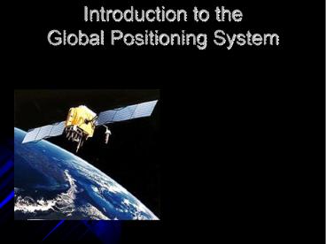
Introduction to the Global Positioning System - PowerPoint PPT Presentation
Title:
Introduction to the Global Positioning System
Description:
Created Date: 10/21/2000 10:10:26 PM Author: ANSHUL SINGH KUSHWAHA Subject: MECHANICAL ENGINEERING Keywords: ROYAL MECHANICAL Title: GPS AND ITS APPLICATION IN ... – PowerPoint PPT presentation
Number of Views:392
Avg rating:3.0/5.0
Title: Introduction to the Global Positioning System
1
Introduction to the Global Positioning System
2
What is the GPS?
- Orbiting navigational satellites
- Transmit position and time data
- Handheld receivers calculate
- latitude
- longitude
- altitude
- velocity
- Developed by Department of Defense
3
Components of the System
- Space segment
- 24 satellite vehicles
- Six orbital planes
- Inclined 55o with respect to equator
- Orbits separated by 60o
- 20,200 km elevation above Earth
- Orbital period of 11 hr 55 min
- Five to eight satellites visible from any point
on Earth - Block I Satellite Vehicle
4
The GPS Constellation
5
GPS Satellite Vehicle
- Weight
- 2370 pounds
- Height
- 16.25 feet
- Width
- 38.025 feet including wing span
- Design life10 years
- Block IIR satellite vehicle assembly at Lockheed
Martin, Valley Forge, PA
6
Components of the System
- User segment
- GPS antennas receiver/processors
- Position
- Velocity
- Precise timing
- Used by
- Aircraft
- Ground vehicles
- Ships
- Individuals
7
Components of the System
- Ground control segment
- Master control station
- Schreiver AFB, Colorado
- Five monitor stations
- Three ground antennas
- Backup control system
8
GPS Communication and Control
9
How does GPS work?
- Satellite ranging
- Satellite locations
- Satellite to user distance
- Need four satellites to determine position
- Distance measurement
- Radio signal traveling at speed of light
- Measure time from satellite to user
- Low-tech simulation
10
How does GPS work?
- Distance to a satellite is determined by
measuring how long a radio signal takes to reach
us from that satellite. - To make the measurement we assume that both the
satellite and our receiver are generating the
same pseudo-random codes at exactly the same
time. - By comparing how late the satellite's
pseudo-random code appears compared to our
receiver's code, we determine how long it took to
reach us. - Multiply that travel time by the speed of light
and you've got distance. - High-tech simulation
11
How does GPS work?
- Accurate timing is the key to measuring distance
to satellites. - Satellites are accurate because they have four
atomic clocks (100,000 each) on board. - Receiver clocks don't have to be too accurate
because an extra satellite range measurement can
remove errors.
12
How does GPS work?
- To use the satellites as references for range
measurements we need to know exactly where they
are. - GPS satAellites are so high up their orbits are
very predictable. - All GPS receivers have an almanac programmed into
their computers that tells them where in the sky
each satellite is, moment by moment. - Minor variations in their orbits are measured by
the Department of Defense. - The error information is sent to the satellites,
to be transmitted along with the timing signals.
13
GPS Position Determination
14
System Performance
- Standard Positioning System
- 100 meters horizontal accuracy
- 156 meters vertical accuracy
- Designed for civilian use
- No user fee or restrictions
- Precise Positioning System
- 22 meters horizontal accuracy
- 27.7 meters vertical accuracy
- Designed for military use
15
System Performance
- Selective availability
- Intentional degradation of signal
- Controls availability of systems full
capabilities - Set to zero May 2000
- Reasons
- Enhanced 911 service
- Car navigation
- Adoption of GPS time standard
- Recreation
16
System Performance
- The earth's ionosphere and atmosphere cause
delays in the GPS signal that translate into
position errors. - Some errors can be factored out using mathematics
and modeling. - The configuration of the satellites in the sky
can magnify other errors. - Differential GPS can reduce errors.
17
Application of GPS Technology
- Location - determining a basic position
- Navigation - getting from one location to another
- Tracking - monitoring the movement of people and
things - Mapping - creating maps of the world
- Timing - bringing precise timing to the world
18
Application of GPS Technology
- Private and recreation
- Traveling by car
- Hiking, climbing, biking
- Vehicle control
- Mapping, survey, geology
- English Channel Tunnel
- Agriculture
- Aviation
- General and commercial
- Spacecraft
- Maritime
19
Classroom Applications
- Physics
- Distance, velocity, time
- Orbital concepts
- Earth Science
- Mapping
- Spacecraft
- Environmental Science
- Migratory patterns
- Population distributions
- GLOBE Program
- Mathematics
- Geography
- Technology
20
Classroom Applications
- Careers
- Aerospace
- Satellite vehicles
- Launch vehicles
- Hardware engineering
- Ground control systems
- User systems
- Software engineering
- Research careers
21
Conclusion
- GPS is finding its place in every corner of our
life. Today, we find many applications of GPS all
around us. - Its like giving every square meter on the planet
a unique address. In future, the airplanes with
GPSRs will be able to land even in dark and in
moist conditions. - In no time GPS will be a complete part of our
life, just as a mobile we have today.


