Chapter 9 Air Masses and Fronts - PowerPoint PPT Presentation
Title:
Chapter 9 Air Masses and Fronts
Description:
Chapter 9 Air Masses and Fronts * Slide22.mp3 If the cold air mass retreats back to the north allowing the warm air mass to advance and replace the colder air at the ... – PowerPoint PPT presentation
Number of Views:218
Avg rating:3.0/5.0
Title: Chapter 9 Air Masses and Fronts
1
Chapter 9Air Masses and Fronts
2
Source RegionsFigure from apollo.lsc.vsc.edu/clas
ses/met130
3
(No Transcript)
4
(No Transcript)
5
(No Transcript)
6
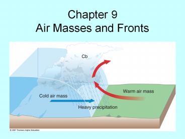
Cold Front
- Cold air advances, replaces warm air at the
surface - Change in wind direction/speed
- Minimum in atmospheric pressure
Fig. 9-14, p. 266
7
Cold Front Cross Section
- A front is a 3-D boundary
- Front slopes back over the cold air mass
- Warm, less dense air is lifted
- Clouds/precipitation associated with a front
depend on stability and moisture - Sharp vertical motion at cold front can force
thunderstorm activity
Fig. 9-15, p. 266
8
Fig. 9-16, p. 267
9
Warm Front
- Warm air advances
- Replaces the cold air at the surface
- Change in wind direction/speed
Fig. 9-17, p. 268
10
Warm Front Cross Section
Fig. 9-18, p. 269
- Front slopes back over the cold air mass
- Slope is more gentle than with a cold front (less
thunderstorm activity) - Warm, less dense air lifted over the cold air
(called overrunning) - Clouds/precipitation depend on moisture and
stability, usually follow a set progression with
an increase in altitude - Responsible for a lot of hazardous winter weather
11
Fig. 9-19, p. 270
12
Stationary Front
- Air masses at surface do not move, so the front
is stationary - Overrunning still occurring, so we often still
see cloudiness - Figure from ww2010.atmos.uiuc.edu
13
Occluded Front
- Separates cool air from relatively colder air at
the surface - Sometimes thought of as the cold front catching
up to warm front - The warm air mass is found above the ground
- Two types
- Cold-type occluded front
- Warm-type occluded front
- Figure from ww2010.atmos.uiuc.edu
14
Development of Occluded FrontFigures from
ww2010.atmos.uiuc.edu
15
Cross Section of Occluded Front
Fig. 9-20, p. 271
16
Occluded Front
17
Dryline
- Dry air (lower dewpoint temperatures) found to
west, moist air (higher dewpoint temperatures)
found to east - Temperature change is rather limited across the
boundary - Common in the southern plains during the spring
- It is a convergence line for wind at the surface,
and is therefore responsible for initiating many
of our tornadic thunderstorms in the south Plains - Motion is tied strongly to insolation, and
typically exhibits a diurnal sloshing motion
(moving eastward during the day, westward at
night)
18
Fig. 9-21, p. 272
19
Air Masses with the Drylinewww.geog.umn.edu/facul
ty/klink/geog1425/images/front/dryline_airmass.jpg
20
Surface Dew Points
21
(No Transcript)
22
5/10/10 Tornado Outbreak
23
http//www.youtube.com/watch?vtdDRBaDRf40
24
(No Transcript)


