251 air masses - PowerPoint PPT Presentation
1 / 26
Title:
251 air masses
Description:
With uniform temperature and moisture conditions. Air Masses are ... An Anemometer measures wind speed; A wind vane measures wind direction. Measuring Huidity ... – PowerPoint PPT presentation
Number of Views:23
Avg rating:3.0/5.0
Title: 251 air masses
1
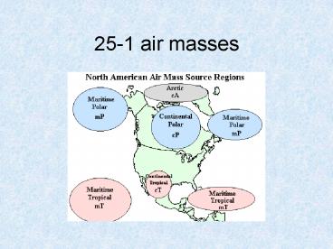
25-1 air masses
2
AIR MASSES An air mass is a large body of
air Subcontinental in size Several miles
high With uniform temperature and moisture
conditions
3
Air Masses are Classified According to
Surface of source region Continental (c)
Forms over land - dry Maritime (m) Forms over
ocean - moist Temperatures Tropical (T)
-Low latitudes - warm Polar (P) - High
latitudes - cold Arctic (A) - Poles - very cold
and dry
4
Fronts
5
COLD FRONT Cold air replaces warm Much
steeper than warm fronts Advances faster than
warm front More violent weather -cumulonimbus
clouds Short, sharp showers
6
Warm front
7
WARM FRONT Warm air replaces cold Gentle
slope (1200) Covers a wide area with its
weather Stratus clouds get lower as front
approaches Drizzle or steady rain
8
(No Transcript)
9
STATIONARY FRONTS Cold and warm air masses
next to each other Neither air mass advances
10
(No Transcript)
11
OCCLUDED FRONTS Cold front overtakes the warm
front Lifts the warm air off the
ground Clouds and rain possible
12
(No Transcript)
13
Wave Cyclone
14
CHANGES IN WEATHER AS A STORM MOVES EAST
(A-E) Wide belt of stratus cloud in advance
of the warm front (A-B) Winds shift SE to SW
along the warm front Tropical maritime air with
clear skies or cumulus clouds (C) Cold front,
winds shift - short, sharp, showers (D) Cooler
temperatures and clearing skies (E) behind the
cold front MID-LATITUDE STORMS EVENTUALLY
DISSOLVE Occlusions close up the
storm Becomes a stationary front
15
WHAT DO HURRICANES AND TORNADOES HAVE IN
COMMON? Low Pressure Latent Heat of
Condensation Strong Winds Hazardous to Life
and Property
16
HOW DO THEY DIFFER? Location Size Duration
Season of Occurrence Distinctive Hazards
17
WHEN DO THEY OCCUR? Hurricane season? Late
Summer and Fall Tornado season? Spring and
Early Summer
18
LOCATION - WHERE DO STORMS FORM? Hurricanes
form over warm (80 F) tropical seas Latitude
7-15 degrees North and South of the equator
Tornadoes form over land in midlatitudes
19
SIZE AND DURATION OF HURRICANES Hurricanes
100-300 miles wide Last 10-14 days Rate of
travel 5 mph Travel with Trade Winds
HURRICANE STRUCTURE Intense low pressure
system Steep pressure gradient - over 74 mph
winds Strong convectional lifting Eye with
calm, clear conditions
20
HURRICANE DAMAGE High winds 75-125
mph Torrential rains Flash floods Storm
surges as sea level rises
21
LOCATION OF TORNADOES Most common in the
United States Plains States, Midwest, and
Florida In advance of a cold front Embedded
in hurricanes SIZE AND DURATION OF
TORNADOES Narrow intense storm 1/4 mile
wide Path of 6 miles SW to NW A few minutes
to three hours
22
STRUCTURE OF A TORNADO Cumulonimbus cloud A
narrow funnel A dust cloud TORNADO
HAZARDS Wind Speed 150-450 kph Strong
updraft in the funnel Explosions due to
pressure contrast
23
Much of the surface weather observations (95 of
them, really) are taken by automated machines
called AWOS or ASOS. The larger airports still
have the sites manned to backup the machines. For
more info on how surface observations are taken
(temperature, dewpoints, sky conditions,
visibility, winds, etc)..click on this official
FAA site regarding ASOS and AWOS systems
Pictures (from University of Illinois) of many
instruments and descriptions Measuring
Temperature - Thermometer measures temperature
(max/min). The National Weather Service keeps the
thermometer six feet above ground in a white box
thus keeping the sensor in the shade. Here's an
example of what that looks like. Measuring
Pressure - Barometer measures pressure. Measurin
g Precipitation - Rain gauge measures
precipitation. There are two major types of rain
gauges used in weather observations. One type is
a tipping bucket and the other is a weighing rain
gauge. Generally, 10" of snow for 1" of rain can
work as a fairly good ration but not always. The
NWS chart can be found here
24
Measuring Winds An Anemometer measures wind
speed A wind vane measures wind direction.
Measuring Huidity - Hygrometer measures
humidity. Measuring Temperature, Dewpoint, and
Humidity (mobile instead of a fixed station)
Sling psychrometer measures wet bulb and dry
bulb form which you can get temp and dewpoint and
relative humidity. Measuring Upper Air Weather
Conditions - Radiosonde is a weather balloon
that radios back to earth upper air
observations.
25
(No Transcript)
26
Forecasting weather
- maps


