Tornadogenesis: Our Current Understanding - PowerPoint PPT Presentation
1 / 19
Title: Tornadogenesis: Our Current Understanding
1
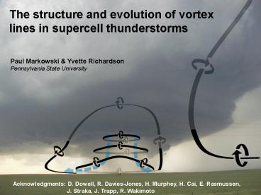
The structure and evolution of vortex lines in
supercell thunderstorms
Paul Markowski Yvette Richardson Pennsylvania
State University
Acknowledgments D. Dowell, R. Davies-Jones, H.
Murphey, H. Cai, E. Rasmussen, J. Straka, J.
Trapp, R. Wakimoto
2
Why vortex lines?
- Although the vertical component of vorticity
tends to be emphasized in supercell thunderstorm
and tornado studies, there is some merit in
systematically inspecting the distribution and
orientation of three-dimensional vortex lines in
observed and simulated storms. - The three-dimensional perspective provided by
vortex lines can expose dynamics that may not be
as apparent in inspections of only one vorticity
component at a time.
3
Why vortex lines?
- The presence of horizontal buoyancy gradients can
complicate vortex line analyses in phenomena like
thunderstorms due to the virtually unavoidable
baroclinic generation of vorticity by the
horizontal buoyancy gradients that accompany the
precipitation regions and vertical drafts of
thunderstorms. - In the presence of significant baroclinic
vorticity generation, vortex lines may not even
closely approximate material lines. - Nonetheless, vortex line analyses still can be
enlightening in that they can suggest plausible
methods of vorticity generation and reorientation
(e.g., observations of vortex rings might lead
one to surmise that a local buoyancy extremum is
present and responsible for the generation of the
rings).
4
Evolution of vortex lines in a simulated
supercell
t 20 min
t 40 min
t 80 min
arches
5
What do the vortex line arches tell us?
Markowski et al. (2008)
Straka et al. (2007)
6
3D wind syntheses obtained via Gamache (1997)
technique using ELDORA pseudo-dual-Doppler
observations
Markowski, P. M., J. M. Straka, E. N. Rasmussen,
R. P. Davies-Jones, Y. Richardson, and J. Trapp,
2008 Vortex lines within low-level mesocyclones
obtained from pseudo-dual-Doppler radar
observations. Mon. Wea. Rev., 136, 3513-3535.
7
Markowski, P. M., J. M. Straka, E. N. Rasmussen,
R. P. Davies-Jones, Y. Richardson, and J. Trapp,
2008 Vortex lines within low-level mesocyclones
obtained from pseudo-dual-Doppler radar
observations. Mon. Wea. Rev., 136, 3513-3535.
8
Rotunno and Klemp (1985)
9
What do the vortex line arches tell us?
baroclinic mechanism (Straka et al. 2007
Markowski et al. 2008)
barotropic mechanism (Davies-Jones 2000, 2007
Markowski et al. 2003, 2008)
negative buoyancy
- vortex lines are frozen in the fluid and move as
material lines (Helmholtz Theorem) - counter-rotating vortices straddle downdraft
- leads to arching vortex lines and
counter-rotating vortices - in actual storms, both environmental and
baroclinic vorticity are likely important
10
max downdraft
Markowski, P. M., J. M. Straka, E. N. Rasmussen,
R. P. Davies-Jones, Y. Richardson, and J. Trapp,
2008 Vortex lines within low-level mesocyclones
obtained from pseudo-dual-Doppler radar
observations. Mon. Wea. Rev., 136, 3513-3535.
11
photo by Jim Marquis
12
Is it possible that the same fundamental
dynamical process (baroclinic vortex lines
generated in a cool downdraft and subsequently
lifted by an updraft) can produce vortices that
range in size and intensity from bookend vortices
to near-ground mesocyclones to tornadoes?
Weisman and Davis (1998)
Fujita (1979)
13
Why do tornadic supercells lack strong cold pools?
- Mobile mesonet observations from Markowski et al.
(2002), Shabbott and Markowski (2006), Grzych et
al. (2007), Hirth et al. (2008) - Climatological studies show that tornadic
supercells are favored when boundary layer
relative humidity is large.
tornadic
nontornadic
Markowski, P. M., J. M. Straka, and E. N.
Rasmussen, 2002 Direct surface thermodynamic
observations within the rear-flank downdrafts of
nontornadic and tornadic supercells. Mon. Wea.
Rev., 130, 1692-1721.
14
Why do tornadic supercells lack strong cold pools?
- Perhaps supercell baroclinity is another
Goldilocks problem whereby at least some
baroclinity is crucial (all thunderstorms have at
least some baroclinity), but too much, especially
near the ground, is detrimental in that large
near-ground baroclinity would imply very cold air
near the ground and thus rapid gust front motion
relative to the main updraft, which might
undercut it (Brooks et al. 2003) or inhibit the
vorticity stretching required by tornadogenesis
(Leslie and Smith 1978 Markowski et al. 2003). - If the downdraft air containing the vortex rings
is too negatively buoyant, then perhaps the end
result is something resembling Fujita's
microburst model rather than significant lifting
of the leading edge of the vortex rings to
produce vertical vorticity.
15
(No Transcript)
16
dual-Doppler analysis of a nontornadic supercell
on 12 June 2004 near Beatrice, NE
view from southwest
3 km
3 km
Majcen, M., P. Markowski, Y. Richardson, and J.
Wurman, 2006 A dual-Doppler analysis of a
nontornadic supercell observed on 12 June 2004
using ground-based mobile radars. Preprints, 23rd
Conf. on Severe Local Storms, St. Louis, MO,
Amer. Meteor. Soc.
17
strong shear
Tornadic storms likely
weak shear
low RH
high RH
Tornadic storms unlikely
courtesy of Harold Brooks
18
Why is the combination of large low-level shear
and high boundary layer RH so favorable for
tornadoes?
- Strong low-level shear promotes stronger
low-level dynamic lifting of baroclinic vortex
lines? - Low LCLs promote weaker cold pools?
19
Summary
- Vortex line arches seem to be a robust trait of
supercell low-level mesocyclone regions - The arching of the vortex lines and the
orientation of the vorticity vector along the
vortex line arches, compared to the orientation
of the ambient (barotropic) vorticity, are
strongly suggestive of (i) baroclinic vorticity
generation within the hook echo and associated
rear-flank downdraft region of the supercells
(ii) subsequent lifting of the baroclinically
altered vortex lines by an updraft, rather than
ambient vortex lines alone being tilted by either
an updraft or downdraft to produce a low-level
vertical vorticity maximum - Not necessarily new dynamics being proposed, but
rather a new way of looking at things that (i)
suggests dynamical similarity to larger-scale
convective systems and (ii) provides possible
insight into why low LCLs and strong low-level
shear is a favorable combination for tornadic
supercells


