
Integration of Java/Java3D Oceanographic Analysis Tools with GIS - PowerPoint PPT Presentation
1 / 1
Title:
Integration of Java/Java3D Oceanographic Analysis Tools with GIS
Description:
Example two: Hydrothermal Plume model output. VTK/Java3D. allows volume. calculations, rendering, and analysis. 3D probe. animation. bathymetry. multibeam. Smith ... – PowerPoint PPT presentation
Number of Views:46
Avg rating:3.0/5.0
Title: Integration of Java/Java3D Oceanographic Analysis Tools with GIS
1
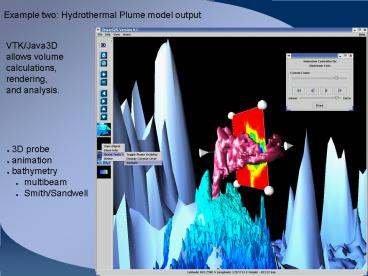
Example two Hydrothermal Plume model output
VTK/Java3D allows volume calculations, rendering,
and analysis.
- 3D probe
- animation
- bathymetry
- multibeam
- Smith/Sandwell
Recommended
CrystalGraphics Presentations


