JanFebMarAprMayJunJulAugSepOctNovDec - PowerPoint PPT Presentation
1 / 1
Title:
JanFebMarAprMayJunJulAugSepOctNovDec
Description:
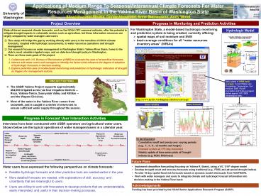
Future Plans. Daily update of WRIA basin averages. ... hydrologic forecast information into decision-making in the Yakima River basin ... – PowerPoint PPT presentation
Number of Views:520
Avg rating:3.0/5.0
Title: JanFebMarAprMayJunJulAugSepOctNovDec
1
Applications of Medium Range To
Seasonal/Interannual Climate Forecasts For Water
Resources Management In the Yakima River Basin of
Washington State Shraddhanand Shukla, Donee
Alexander, Anne Steinemann, Andy Wood
University of Washington
Progress in Monitoring and Prediction Activities
Project Overview
- For Washington State, a model-based hydrologic
monitoring and prediction system is being
created, currently offering - spatial maps of soil moisture and SWE
- basin average conditions for all water resources
inventory areas (WRIAs)
Hydrologic Model
- State-of-the-art seasonal climate forecasts, such
as the NOAA CPC seasonal outlooks, offer the
potential to mitigate drought impacts in
vulnerable sectors such as agriculture, but these
information resources are largely untapped by
water managers and users. - This study will bridge the gap by working
directly with users in the transition of NOAA
climate forecasts, coupled with hydrologic
assessments, to water resources operations and
drought management. - Our research focuses on water management in
Washington States Yakima River Basin, home to
the state's most valuable irrigated crops, and on
state-level drought policy in Washington. - There are three main goals of the project
- Collaborate with U.S. Bureau of Reclamation
(USBR) to evaluate the uses of streamflow
forecasts. - Interact with water users and managers to
identify the factors that influence the degree of
adoption of hydrologic forecasts in
decision-making. - Explore potential uses of model-based monitoring
and prediction of hydrologic indicators of
drought as triggers for management actions.
PROJECT SETTING
Daily update of WRIA basin averages. Current
Water year Precipitation, Temperature, Soil
moisture, SWE, Runoff (cumulative and 5-day
averages) plotted against 1971-2000
climatological data)
- The USBR Yakima Project supports approximately
464,000 irrigated acres (via four irrigation
districts -- Roza, Yakima-Tieton, Sunnyside
Valley and Kittitas -- and the Wapato Division). - Most of the water in the Yakima River comes from
snowmelt, and is caught in a series of reservoirs
to ensure sufficient water supply throughout the
season.
http//www.hydro.washington.edu/forecast/sarp/
Other Products
Other variables
Progress in Forecast User Interaction Activities
Interviews have been conducted with USBR
operators and agricultural water users. Shown
below are the typical operations of water
managers/users in a calendar year.
SWE
Jan--------Feb-------Mar-------Apr--------May--
------Jun--------Jul--------Aug--------Sep--------
Oct--------Nov--------Dec--
Initial Monthly Water Forecast Issued
------------------------------ Water Deliveries
----------------------------------
Reservoir Operations For Fall Crop
Reservoir Drawdowns For Flood Control
Summer Water Allocations Decided
Reservoir Refill
IN development Cumulative runoff and precip
over varying periods (e.g., 1-, 3-, 6-, 12-months
and longer) Nowcast system at 1/16 deg
resolution Weekly update of time-series plots
of Drought indexes (e.g. PDSI, PHDI etcs)
Fields Prepped Seed Bought
Repairs / Preparations for irrigation season
In good years, Fall Crop
In drought years, decisions about selling water
fallowing fields
------------------------------Irrigation
Season----------------------------------
Future Plans
- Implement streamflow forecasting (focusing on
Yakima R. Basin), using a VIC 1/16th degree model - Develop drought onset and recovery forecasts
using traditional (e.g., PDSI) and advanced
drought indices - Provide 15-day spatial flood risk forecasts
based on dynamic model reforecasts from NCEP/ESRL
- Work with water managers and users to integrate
climate and hydrologic forecast information into
decision-making in the Yakima River basin - Funding has been provided by the NOAA Sector
Applications Research Program (SARP).
Water users have expressed the following
perspectives on climate forecasts
- Reliable hydrologic forecasts and other
predictive tools are needed earlier in the year. - More detailed forecasts are needed, with
explanations of skill, accuracy, and uncertainty
that are meaningful to users. - Users are willing to work with forecasters to
develop products that are understandable, easily
interpreted, and useful in their decision-making
processes.
Acknowledgements


