Tropical Rainfall Measuring Mission TRMM - PowerPoint PPT Presentation
1 / 8
Title:
Tropical Rainfall Measuring Mission TRMM
Description:
Tropical Rainfall Measuring Mission (TRMM) TRMM Multi-Satellite Real-Time ... Near global merged precipitation estimates using TRMM, polar-orbit microwave, ... – PowerPoint PPT presentation
Number of Views:192
Avg rating:3.0/5.0
Title: Tropical Rainfall Measuring Mission TRMM
1
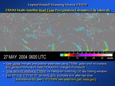
Tropical Rainfall Measuring Mission (TRMM) TRMM
Multi-Satellite Real-Time Precipitation Estimates
(3-hr interval)
Near global merged precipitation estimates
using TRMM, polar-orbit microwave, and
geosynchronous-IR data (NOAA/CPC merged IR
product) Bias removal relative to TRMM via
histogram matching (30 day trailing
window) 3-hr, 50N-S 0.25x0.25 lat./long.
grid available 4-hr after real time (available
via ftp see U.S. TRMM web sitetrmm.gsfc.nasa.gov
)
2
TRMM Multi-Satellite Real-Time Precipitation
Estimates
3B40RT Combined microwave (TRMM and
TRMM-calibrated SSM/I)
3B41RT Microwave-calibrated geo-IR
estimate (Geo-IR from NOAA/CPC)
3B42RT Merged microwave and geo-IR estimates
Adler/Huffman
3
TRMM Data Used by USAID, USGS for Crop Forecasts
USAID Famine Early Warning System Network
(USAID/FEWS-Net) is a joint program of DoS, USGS,
NOAA Goal is crop and weather assessment around
the world
TRMM real-time Multi-Satellite Precipitation
Analysis (MPA) tested in 2003 first results are
promising MPA now in quasi-operational use in
Central America, Africa, and Asia
4
Heavy Rains/Flooding in Dominican Republic
Peak total for 24 hour about 430 mm
5
Example Day of Validation over Australia Beth
Ebert (BMRC-Australia)
6
Limitations of TRMM-based Multi-satellite
Precipitation Analysis (MPA)
- Biases related to satellite retrievals (over
land) -Solution improved retrievals, use of
TRMM PR data, calibration by gauges - False precipitation signals due to cold and/or
wet ground mainly in middle/high latitudes cool
season -Solution improved retrievals, better
screening, use of high frequency PMW, use of
TOVS/AIRS data, eventual use of GPM radars for
calibration - Underestimation of shallow, orographic
precipitation -Solution Use of TRMM (and
eventually GPM) radar for calibration of
passive techniques - Limitations of IR-based rain estimation -Solution
more microwave via GPM constellation, others
7
Plans for TRMM-based Multi-Satellite, 3-hr
Analysis
- Real-time analysis will incorporate PR
information as calibrator - Non real-time analysis (TRMM product 3B-42) will
become 3-hr in in Version 6, from Jan. 1, 1998 - AMSR, AMSU data will be added in both standard
(research) and real-time product - Real-time product will use monthly gauges
(previous months/years) to improve bias (if
necessary) - An improved geo-IR technique (e.g., Convective
Stratiform Technique CST) may be implemented if
tests indicate improvement - Working on extension to high latitudes using
AMSU, TOVS and AIRS - Improved techniques for merging/blending
- TRMM V6 3B-42/43 may be a tool to improve GPCP
global products (include TRMM, go to 3 hr, and
use TRMM to calibrate 25 year data set
8
AMSR and AMSU Data Will Improve the TRMM MPA
Current combined microwave data coverage
Averages 44 with F13, F14, F15, and
TRMM Coverage with AMSR-E Adds
11 Coverage with AMSR-E and all 3 AMSU-B
Adds 33


