Web GIS Oregon Explorer - PowerPoint PPT Presentation
Title:
Web GIS Oregon Explorer
Description:
Web GIS Oregon Explorer Marc G Rempel Oregon State University The Valley Library Oregon Explorer marc.rempel_at_oregonstate.edu What is the Oregon Explorer? – PowerPoint PPT presentation
Number of Views:65
Avg rating:3.0/5.0
Title: Web GIS Oregon Explorer
1
Web GISOregon Explorer
Marc G Rempel Oregon State University The Valley
Library Oregon Explorer marc.rempel_at_oregonstate.ed
u
2
What is the Oregon Explorer?
- Natural Resources Digital Library
- Place-based resources
- Supports informed natural resource decision-making
3
Evolution of the Oregon Explorer
- Basin Portals
- e.g. Willamette Basin Explorer
- Topic Portals
- e.g. Land Use Explorer
- Data Portals
- e.g. Imagery Explorer
- Oregon Spatial Data Library
4
Components of Web GIS
- 1. Spatial Data
- 2. Web Server
- 3. Map/GIS Server
- 4. Mapping Application
- 5. Application Enhancements (optional)
MapServer example
5
Components of Web GIS- Spatial Data
Examples of Spatial Data
- Shapefiles/ Geodatabases (ESRI)
- KML/KMZ (Google Earth)
- GeoRSS/GeoJson
- Web services
- WMS Web Mapping Services (image)
- WFS Web Feature Services (vector)
- WCS Web Coverage Services (raster)
6
Components of Web GIS- Web Server
Examples of Web Servers
- Apache Tomcat
- IIS (Windows)
Web Servers provide the foundation for serving
out data on the web.
7
Components of Web GIS- Map/GIS Servers
Examples of Mapping Servers
- ArcIMS
- ArcGIS Server
- GeoServer
- MapServer
8
Components of Web GIS- Map/GIS Servers
Role of Map/GIS Servers
- Serve spatial data via the internet.
- When a request comes to the web server, the
Map/GIS server application handles the request
and returns a map image, attribute, geometry or
downloadable data. - The Map/GIS server can also return images of
legends, scale bars and reference maps. - Requests can query the spatial data and return
only the data that matches the request. - Some Map/GIS servers also support geometry,
geocoding and geo-processing tasks requests.
(i.e. buffer queries, clipping, etc).
9
Components of Web GIS- Map/GIS Servers
Map/GIS Server Services
- A Map/GIS server can have multiple services of
various types. - Map service
- Geoprocessing service
- Geodata service
- Image service
- Geometry service
- Geocoding service
- Globe service
- A map service is a specified grouping of spatial
data with projection and display information
defined. For ESRI, a .mxd file can serve as the
source for a map service. - A Map/GIS server can allow for map services to be
started and stopped. - A map service can support multiple output formats
(WMS, WFS, KML)
10
Components of Web GIS- Map/GIS Servers
Map/GIS Server Services ESRI Example ArcCatalog
11
Components of Web GIS- Map/GIS Servers
REST and SOAP API
- Some Map/GIS Servers expose their services via
REST and SOAP APIs. - REST API
- Representational State Transfer (REST) is a
stateless protocol for leveraging representations
of service data and methods. - Provides a lightweight interface to access
service properties and functionality through
client side script. - Example http//methionine.library.oregonstate.ed
u/ArcGIS/rest/services - SOAP API
- Simple Object Access Protocol (SOAP) is a
protocol for creating server side classes and
methods for a web service. SOAP tends to have
more robust capability over REST, but can be more
complicated to incorporate. - Example http//methionine.library.oregonstate.ed
u/ArcGIS/services/Restoration/OWRI_07_1/MapServer?
wsdl
12
Components of Web GIS- Mapping Applications
- A mapping application is a web component/page
that handles requests/responses to and from the
mapping server. - Typical functionality includes handling
navigation panning/zooming, layer management,
attribute queries and advanced processing tasks
(buffer, distance calculations, etc).
Examples of extensible Mapping Applications
- ESRI WebADF/JavaScript API
- Google Maps API /ArcGIS JS Extension
- Google Earth API
- Bing Maps API /ArcGIS JS Extension
- Bing Maps Silverlight API (Microsoft)
- Flex (Adobe) / ArcGIS Extension
- Yahoo Maps API
- OpenLayers API
- ArcGIS for iPhone API coming soon.
13
Components of Web GIS- JavaScript Class Libraries
- JavaScript class libraries are an optional piece
of a web GIS stack that can add some dynamic user
interface components such as sliders, pop-up
boxes, dynamic table grids, and AJAX
(Asynchronous JavaScript and XML) handling. - Some popular JavaScript class libraries to
consider are
Dojo EXT.JS YUI (Yahoo User
Interface) jQuery Can get from
http//code.google.com/apis/ajaxlibs/
14
What is a mashup?
- a mashup is a web page or application that
combines data or functionality from two or more
external sources to create a new service. - The term mashup implies easy, fast integration,
frequently using open APIs and data sources to
produce results that were not the original reason
for producing the raw source data. - Source Wikipedia.
15
A simple web mapping application
- Basic HTML and JavaScript will get you a long
ways.
16
ESRI Resource Center
http//resources.esri.com/arcgisserver/index.cfm?f
ahome
17
Examples of Mapping Mash-ups
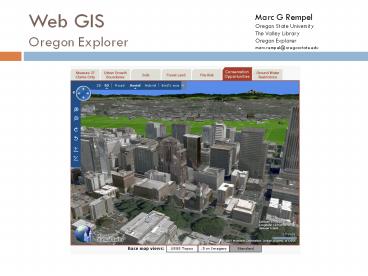
- Measure 37 Viewer
- ORWAP
- Oregon Restoration
18
Measure 37 Viewerhttp//oeapp.oregonexplorer.info
/M37Viewer
- Virtual Earth/Bing Maps- JavaScript API
- Overlay WMS from ArcIMS
- Transparency slider, legend
- Create active objects (pushpins, polygons).
- Uses GET_FEATURES call to ArcIMS to draw
polygons. - 3D Functionality.
19
ORWAP- Oregon Rapid Wetland Assessment Protocol
http//oregonexplorer.info/wetlands/ORWAP/
- Uses ArcGIS server map and geometry services.
- Buffers selected point and queries intersection
of layers. - Uses Virtual Earth/Bing JavaScript Extension for
ArcGIS server.
20
Oregon Watershed Restoration Tool
- ArcGIS Server 9.3 mapping backend
- Bing GeoRSS Collections for basin, subbasin and
watershed council layers. - REST and SOAP used for getting layer data and
overlaying WMS. - DOJO javascript class library for more
interactive user interface.


