Before Hugo - PowerPoint PPT Presentation
1 / 40
Title:
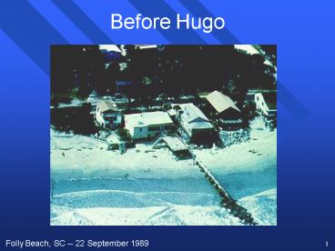
Before Hugo
Description:
Temperature of the land is cooler than the warm ocean. Moved under unfavorable large scale flow. ... Weather Channel Reporters! 5. Satellite Detection of Camille ... – PowerPoint PPT presentation
Number of Views:85
Avg rating:3.0/5.0
Title: Before Hugo
1
Before Hugo
Folly Beach, SC -- 22 September 1989
2
After Hugo
Folly Beach, SC -- 22 September 1989
3
Death of a Hurricane
- Moves out of the warm, moist tropical air.
- Moves over land.
- Loss of moisture source
- Increased surface friction
- Temperature of the land is cooler than the warm
ocean - Moved under unfavorable large scale flow.
- High shear can rip a storm apart
- Large scale subsidence can inhibit convection
4
Hurricane Warnings
- Hurricane warnings are designed to protect human
life and their property. - Possible Evacuations
- Detection techniques
- Satellites
- Radar
- Aircraft Reconnaissance
- Data Buoys
- Weather Channel Reporters!
5
Satellite Detection of Camille
NIMBUS III Satellite -- 21 August 1969
6
Satellite Tracking of Allen
Hurricane Allen -- August 1980
7
Satellite Tracking of Allen
Hurricane Allen -- August 1980
8
Satellite Tracking of Allen
Hurricane Allen -- August 1980
9
Radar Detection of Hurricanes
Hurricane Andrew -- August 24, 1992
10
Aircraft Detection of Hurricanes
WP-3 Aircraft
Dropsondes
11
Tropical Storm Warnings
- Tropical Storm Watch
- Possible tropical storm conditions expected in
the next 36 hours. - Prepare to take appropriate action.
- Tropical Storm Warning
- Tropical storm conditions are expected in the
next 24 hours. - Take action!
12
Hurricane Warnings
- Hurricane Watch
- Possible hurricane conditions expected in the
next 36 hours. - Prepare to take appropriate action.
- Hurricane Warning
- Hurricane conditions are expected in the next 24
hours. - Get out of Dodge!
13
Hurricane Warning!
14
Building for Disaster?
- 45 million people now live along hurricane-prone
regions in the U.S. - Gulf Coast population
- 1960 -- 5.2 Million
- 1990 -- 10.1 Million
- Doubled in only 30 years.
- Florida to Virginia
- 1960 -- 4.4 Million
- 1990 -- 9.2 Million
15
Can We Evacuate?
- Hurricane evacuation times currently range from
15 - 30 hours depending on the locale. - Current warnings are only valid for 24 hours.
- Can the transportation infrastructure handle such
a mass exodus quickly enough?
16
Building for Disaster?
- We are constructing more and larger dwellings
along our hurricane-prone coastlines.
17
Building for Disaster?
Miami, FL
18
Better Construction
- Improved construction techniques may help
alleviate some storm damage. - Reinforcing seawalls
- Creating larger sand dunes and beaches
- Building housing on stilts
- Better tie-downs between the foundation and the
walls and between the walls and the roof. - Not much will stop a 7 m storm surge.
19
Is This Better?
20
Prediction Difficulty
- We still have difficulty predicting the precise
landfall of most hurricanes. - Some hurricanes can loop.
- What if we evacuate and the hurricane goes
elsewhere -- the Cry Wolf problem. - False alarms are still high and many people
become apathetic. - We see that here with tornado watches and
warnings!
21
Prediction Difficulty
Hurricane Elena -- 28 August - 4 September 1985
22
Possible Solutions
- Increased Research on Hurricane Prediction
- Evacuation Studies
- Emergency procedures in the event evacuation is
not feasible - Population growth management
- Hurricane education
- Improved construction building codes
- Wetland management
- Hurricane Modification ????
23
Saffir-Simpson Intensity Scale
24
Conservation of Angular Momentum
- Quantification of the ice skater analogy
- This is the primary source of high wind speeds
- The quantity VR, known as angular momentum, is
constant for any given air parcel (can differ
from parcel to parcel) - V is the tangential wind
- R is the radial distance of the air parcel from
the hurricane eye
25
Conservation of Angular Momentum
Eye
V x R Constant
V
V is the tangential wind R is the
radialdistance of the air parcel from the
hurricane eye
Eye
R
Hurricane
26
Conservation of Angular Momentum
Eye
V x R Constant
V
What happens asan air parcelspirals
inwardtoward the centerof the hurricane?
Eye
R
27
Conservation of Angular Momentum
Eye
V1
V x R Constant
What happens asan air parcelspirals
inwardtoward the centerof the hurricane?
Eye
R1
28
Conservation of Angular Momentum
Eye
V1
V x R Constant
What happens asan air parcelspirals
inwardtoward the centerof the hurricane?
Eye
R1
V2
29
Conservation of Angular Momentum
Eye
V1
V x R Constant
What happens asan air parcelspirals
inwardtoward the centerof the hurricane?
Eye
R1
R2
V2
30
Conservation of Angular Momentum
V x R Constantsimply means that
Eye
V1
V1 x R1 V2 x R2
Eye
R1
R2
V2
31
Conservation of Angular Momentum
Eye
V1
Let V1 10 ktsR1 500 km If R2 30 km,
thenusing the equation V1 x R1 V2 x R2 we find
that V2 (V1xR1)/R2 V2 167 kts!!!
Eye
R1
R2
V2
32
Conservation of Angular Momentum
Note spiral bands converging towardthe center
33
Conservation of Angular Momentum
- The same mechanism is at work in tornadoes
- The flow is in the tangential direction, or in
the direction of spin, but there also exists a
radial inflow toward the center of the vortex, or
a spiraling-inward flow
34
Hurricanes Often ProduceTornadoes Distribution
Hurricane Motion
Location of allhurricane-spawnedtornadoes
relativeto hurricane centerand motion
(McCaul, 1991)
35
Hurricanes Often ProduceTornadoes Hodographs
Composite hodographsby hurricane
quadrant (McCaul, 1991)
36
Tornadoes as a functionof range from the
centerof a hurricane. (McCaul, 1991)
37
Tropical Weather Climatology
Tropical Storms
Hurricanes
38
New Technology Dropsondes
39
New Technology Dropsondes
40
New Technology Dropsondes
Slides Showing the Improvement in Hurricane
Track Forecasts with Dropsondes


![READ⚡[PDF]✔ Of Power and Right: Hugo Black, William O. Douglas, and America's PowerPoint PPT Presentation](https://s3.amazonaws.com/images.powershow.com/10069071.th0.jpg?_=20240701047)


