Identifying Provinces and Territories of Canada - PowerPoint PPT Presentation
1 / 9
Title:
Identifying Provinces and Territories of Canada
Description:
Based on a free enterprise system like U.S. individuals and groups rather than ... country in the world, but most of its people live near its borders with the US. ... – PowerPoint PPT presentation
Number of Views:853
Avg rating:3.0/5.0
Title: Identifying Provinces and Territories of Canada
1
(No Transcript)
2
(No Transcript)
3
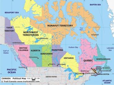
Identifying Provinces and Territories of
Canada Color the province and territories map of
Canada. Create a color code key for the
provinces. Use page ___________ in your book.
Label each province and territory and the
provincial capital city. Use page ________ in
your textbook to help you. Atlas page
______________ This ditto and map will help you
remember the provinces and territories Yes ---
Yukon No ---- North West Territories Body ---
British Columbia Ate --- Alberta Sausages ---
Saskatchewan Monday --- Manitoba Only ---
Ontario Queens --- Quebec Pout --- Prince Edwards
Islands 3 Ns --- New Foundland
New Brunswick Nova Scotia Nothing
---- Nunavat Locate these bodies of water Artic
Ocean Atlantic Ocean Pacific Ocean Hudson
Bay Great Lakes list each
4
Economy
- Based on a free enterprise system like U.S.
individuals and groups rather than the government
run businesses - Farmers raise meats, grains, vegetables, and
fruits - Food production has increased, but the number of
farms and workers had decreased due to advanced
farming techniques. - Rich in minerals such as copper, iron ore,
nickel, silver, oil, natural gas, and coal
5
People
- Most Americans and Canadians are Europeans in
origin. - English is the major language in both Canada and
the US, but French is also a dominant language in
Canada. - In land area, Canada is the second-largest
country in the world, but most of its people live
near its borders with the US.
6
Culture
- At least 12,500 years ago, the ancestors of
Native Americans settled North America. - Europeans arrived between the 1500s and the
1700s. When thousands of immigrants arrived in
the late 1800s and early 1900s, the US
transformed from an agricultural economy to an
industrial economy. - Canada won its independence from Great Britain
during the 1800s and early 1900s. - A big issue that threatens national unity in
Canada is the differences between
English-speaking and French-speaking citizens.
7
The Land
- The US and Canada cover more than 7 million
square miles. - The largest mountain range in these two countries
is the Rocky Mountains which stretches from
Alaska to New Mexico. - In the center of the US and Canada are the broad,
rolling Great Plains. - In the eastern part of these two countries, the
second longest mountain range exists the
Appalachian Mountains. - The largest river system in North America is the
Mississippi River. - The largest lake system is the Great Lakes, made
up of five lakes that are interconnected. Those
lakes eventually meet the St. Lawrence River and
flow into the Atlantic Ocean. - Canadian Shield horseshoe-shaped region wrapped
around the Hudson Bay - Toronto is Canadas largest city.
- Cordillera group of mountain ranges that run
side by side
8
Climate and Vegetation
- Northern Canada and Alaska have short, cool
summers and long, cold winters. - Thousands of years ago, huge glaciers or giant
sheets of ice, covered most of Canada. The
weight of the glaciers pushed much of the land
down and created a large, low basin. - Much of the land mass is inhabitable due to the
harsh climate
9
What can you locate? Students were given another
map of Canada.
- Color the Northwest Territory Yellow. label
- Color Quebec pink. label
- Color Nunavat orange label
- Color Alberta light blue label
- Color Newfoundland royal blue label
- Color Manitoba purple - label


