
Source Water - PowerPoint PPT Presentation
1 / 17
Title:
Source Water
Description:
Watersheds of public water supply intakes (within a reasonable area) ... Streamside vegetation (riparian buffers) can prevent some contaminants from reaching streams. ... – PowerPoint PPT presentation
Number of Views:45
Avg rating:3.0/5.0
Title: Source Water
1
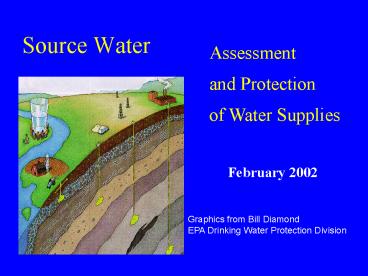
Source Water
Assessment and Protection of Water Supplies
February 2002
Graphics from Bill Diamond EPA Drinking Water
Protection Division
2
Protect what?
- Watersheds of public water supply intakes (within
a reasonable area) - Recharge areas of public water supply wells
3
Source Water Assessment Protection
Program (168,000 PWSs Must Have Complete
Assessments By 2003)
2,156 (98)
4,211 (96)
2,103 (98)
1,347 (95)
550 (96)
2,023 (97)
8,352 (98)
1,628 (85)
2,645 (96)
10,630 (97)
11,724 (99)
718 (96)
2,080 (98)
479 (94)
12,350 (98)
736 (97)
10,389 (97)
3,705 (98)
1,932 (94)
4,279 (95)
5,939 (95)
1,329 (97)
4,837 (96)
675 (95)
551 (97)
5,801 (93)
1,414 (94)
3,815 (98)
953 (91)
3,776 (96)
2,101 (95)
1,079 (93)
2,701 (94)
8,146 (91)
712 (67)
7,511 (97)
1,173 (79)
1,527 (90)
1,732 (93)
1,199 (89)
1,274 (95)
1,687 (94)
2,572 (92)
1,645 (98)
1,485 (88)
702 (63)
Puerto Rico 490 (74)
1,820 (87)
6,865 (89)
141 (74)
6,607 (94)
1996 SDWA
Source Water Assessments
Source Water Protection
2003
1. Delineate Source Water area
5. Establish local SW protection risk
management measures
2. Contamination source inventory
6. Develop Contingency Plans
3. Susceptibility Determinations
4. Public distribution discussion of findings
Consumer Confidence Reports
4
Source Water Protection Areas
Ground Water
Surface Water
Wellhead Protection Recharge Area
5
Three zones for a river intake
6
Intake in a Large Reservoir
Zone 1
Zone 2
Zone 3
7
Whats the risk?
- Susceptibility
- the potential for a public water system to draw
water that is contaminated. - A Susceptibility Analysis provides
- technical rationale for management strategies
- information to the consuming public
- (included in the Consumer Confidence report)
8
Inventory evaluate potential contaminants
9
Data sets considered in inventory
- Abandoned oil wells
- Airports
- Roads rails near streams
- Waste treatment, storage or disposal facilities
- Waste generators or transporters
- Superfund sites
- Landfills, orphan and active
- KPDES permits
- and . . .
10
Inventory more data sets
- Natural gas lines
- parks
- Underground storage tanks
- Facilities handling toxics
- Underground injection wells
- Land cover
- Active abandoned mines
- Sewer lines
11
Analysis Factors
- Location in which protection area
- Contaminant value relative toxicity
- Groundwater sensitivity (for well only)
- Likelihood of release (for surface intake only)
12
(No Transcript)
13
Assessments will result in
- Public notice, awareness and education.
- Better, scientific understanding of the potential
threats to the water supply. - Public involvement, if incorporated during
inventory. - A tool to help make decisions about protecting
drinking water.
14
What will protect water sources?
- Good housekeeping practices can minimize
contaminant release. - Streamside vegetation (riparian buffers) can
prevent some contaminants from reaching streams. - Control land by purchasing or securing easements
can prevent siting of contaminants in key
locations (Zone I, for example).
15
How will protection happen?
- Strict enforcement of existing regulations for
managing potential contaminants. - Voluntary management practices on private lands.
- Incentives to landowners and business
- Local ordinances to protection supply areas.
- County- or region-wide wastewater planning
- Planning and zoning
16
Laying the groundwork for protection
- Area Development Districts are facilitating local
review of - Protection areas for accuracy and size
- Inventory data for accuracy and additional
(e.g. septic system areas, agricultural
practices, other potential nonpoint sources.) - Narrative conclusions
17
When?
- The federal government requires assessments by
May, 2003. - Water Mgt Planning requires assessments and
protection recommendations within 5 years of the
first Water Supply Plan approval. - Earliest due date will be at least 3 months after
release of draft information from DOW. - Conclusions to appear in Consumer Confidence
Reports within year
Recommended
CrystalGraphics Presentations


