Types of Fronts - PowerPoint PPT Presentation
1 / 18
Title:
Types of Fronts
Description:
Types of Fronts Stationary front A front that is not moving. Cold front is a leading edge of colder air that is replacing warmer air. Warm front is a leading edge of ... – PowerPoint PPT presentation
Number of Views:155
Avg rating:3.0/5.0
Title: Types of Fronts
1
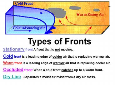
Types of Fronts Stationary front A front that
is not moving. Cold front is a leading edge of
colder air that is replacing warmer air. Warm
front is a leading edge of warmer air that is
replacing cooler air. Occluded front When a
cold front catches up to a warm front. Dry Line
Separates a moist air mass from a dry air mass.
2
A. Cold Front is a transition zone from warm air
to cold air. A cold front is defined as the
transition zone where a cold air mass is
replacing a warmer air mass. Cold fronts
generally move from northwest to southeast. The
air behind a cold front is noticeably colder and
drier than the air ahead of it. When a cold
front passes through, temperatures can drop more
than 15 degrees within the first hour.
3
The station east of the front reported a
temperature of 55 degrees Fahrenheit while a
short distance behind the front, the temperature
decreased to 38 degrees. An abrupt temperature
change over a short distance is a good indicator
that a front is located somewhere in between.
4
B. Warm Front. A transition zone from cold air
to warm air. A warm front is defined as the
transition zone where a warm air mass is
replacing a cold air mass. Warm fronts
generally move from southwest to northeast and
the air behind a warm front is warmer and more
moist than the air ahead of it. When a warm
front passes through, the air becomes noticeably
warmer and more humid than it was before.
5
Diagram of Warm and Cold Fronts
6
Looking at a Cold Front in more detail
7
Another view of a Cold Front
8
Looking at details of a Warm Front
9
Another view of the Warm Front
10
C. Stationary Front a front that is not moving.
When a warm or cold front stops moving, it
becomes a stationary front. Once this boundary
resumes its forward motion, it once again becomes
a warm front or cold front. A stationary front
is represented by alternating blue and red lines
with blue triangles pointing towards the warmer
air and red semicircles pointing towards the
colder air.
11
D. Occluded Front - when a cold front overtakes a
warm front. A developing cyclone typically has
a preceding warm front (the leading edge of a
warm moist air mass) and a faster moving cold
front (the leading edge of a colder drier air
mass wrapping around the storm). North of the
warm front is a mass of cooler air that was in
place before the storm even entered the region.
12
As the storm intensifies, the cold front rotates
around the storm and catches the warm front.
This forms an occluded front, which is the
boundary that separates the new cold air mass (to
the west) from the older cool air mass already in
place north of the warm front. Symbolically, an
occluded front is represented by a solid line
with alternating triangles and circles pointing
the direction the front is moving.
13
Formation of an Occluded Front
14
Two Types of Occluded Fronts
15
Special situation of an Occluded Front
16
Dry Line is a moisture boundary. A dry line is
a boundary that separates a moist air mass from a
dry air mass.
Also called a "Dew Point Front", sharp changes
in dew point temperature can be observed across a
dry line. Dry lines are most commonly found
just east of the Rocky Mountains, separating a
warm moist air mass to the east from a hot dry
air mass to the west.
17
Actual Weather Map Yellow dashes mark the Dry
Line
18
On the previous weather map Dew points east
(ahead) of the dry line shown above range from
the upper 50's to low 70's with winds from the
southeast. West of the dry line, dew points
were in the 20's and 30's, a decrease of nearly
50 degrees. Air temperatures ahead of the dry
line were generally in the 70's and 80's while
behind the dry line, temperatures ranged from the
mid 80's to mid 90's. Drier air behind dry
lines lifts the moist air ahead of it, triggering
the development of thunderstorms along and ahead
of the dry line (similar to cold fronts). It is
not uncommon for tornadic super cells to develop
along a dry line.


