
Development of a visibility retrieval for the GOES-R Advanced Baseline Imager
Title:
Development of a visibility retrieval for the GOES-R Advanced Baseline Imager
Description:
Development of a visibility retrieval for the GOES-R Advanced Baseline Imager R. Bradley Pierce1 (GOVERNMENT PRINCIPAL INVESTIGATOR) , Allen Lenzen2, Mike Pavolonis1 ... –
Number of Views:73
Avg rating:3.0/5.0
Title: Development of a visibility retrieval for the GOES-R Advanced Baseline Imager
1
Development of a visibility retrieval for the
GOES-R Advanced Baseline Imager
R. Bradley Pierce1 (GOVERNMENT PRINCIPAL
INVESTIGATOR) , Allen Lenzen2, Mike Pavolonis1,
Andrew Heidinger1, Shobha Kondragunta1 1NOAA/NESDI
S/STAR, 2University of Wisconsin Space Science
and Engineering Center (SSEC)
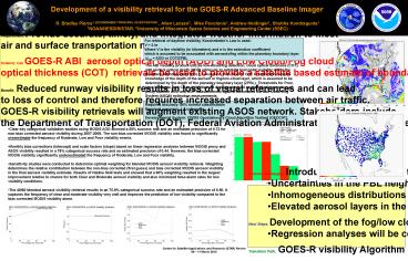
Requirement Provide accurate, timely, and
integrated weather information to meet air and
surface transportation needs Science Can GOES-R
ABI aerosol optical depth (AOD) and Low
Cloud/Fog cloud optical thickness (COT)
retrievals be used to provide a satellite based
estimate of boundary layer extinction to augment
existing Automated Surface Observing System
(ASOS) visibility measurements? Benefit
Reduced runway visibility results in loss of
visual references and can lead to loss of
control and therefore requires increased
separation between air traffic. GOES-R
visibility retrievals will augment existing ASOS
network. Stakeholders include the Department of
Transportation (DOT), Federal Aviation
Administration (FAA), Department of Defense
(DOD), the NOAA Aviation Weather Center (AWC) and
National Weather Service (NWS), as well as
Private Industry, General Aviation (GA), and
International Civil Aviation Organization (ICAO)
global aviation standards.
For retrieval of daytime visibility,
Koschmieders Law is used V 3./s Where V is
the visibility (in kilometers) and s is the
extinction coefficient which is assumed to be
associated with aerosols/fog within the planetary
boundary layer spbl AOD or COT/ZPBL
The ABI visibility product utilizes low-cloud/fog
detection, cloud optical thickness (COT), and
aerosol optical depth (AOD) retrievals to
estimate horizontal visibility within the
planetary boundary layer (PBL). Conversion from
AOD or COT to extinction requires knowledge of
the depth of the aerosol or fog/low-cloud layer,
which is assumed to be determined by the depth of
the planetary boundary layer (ZPBL). Thresholds
for Poor, Low, Moderate, and Clear visibilities
are developed based on statistical regression of
proxy satellite AOD and COT measurements against
Automated Surface Observing System (ASOS)
extinction measurements. Required accuracy 80
correct classification Required precision 1.5
categories Developmental System CIMSS
Geostationary Cloud Algorithm Testbed (GEOCAT).
- Clear-sky categorical validation studies using
MODIS AOD showed a 58 success rate and an
estimated precision of 0.72 for non-bias
corrected aerosol visibility during 2007-2008.
The non-bias corrected MODIS visibility was found
to significantly overestimate the frequency of
Moderate, Low and Poor visibility events. - Monthly bias corrections (intercept) and scale
factors (slope) based on linear regression
analyses between MODIS proxy and ASOS visibility
resulted in a 78 categorical success rate and an
estimated precision of 0.44. However, the
bias-corrected MODIS visibility significantly
underestimated the frequency of Moderate, Low and
Poor visibility. - Sensitivity studies were conducted to determine
optimal weighting for blended MODIS aerosol
visibility retrieval. Weighting determines the
relative contribution between the non-bias
corrected (first guess) and bias corrected MODIS
aerosol visibility in the final aerosol
visibility estimate. Results of Heidke Skill
tests and showed that a 60 weighting resulted in
the largest improvement relative to chance for
both Clear and Moderate aerosol visibility and
also minimized false alarm rates for low
visibility conditions. - The 40/60 blended aerosol visibility retrieval
results in an 75.8 categorical success rate and
an estimated precision of 0.50. It captures the
frequency of clear and moderate visibility very
well and improves the prediction of low
visibility compared to the bias corrected MODIS
visibility alone.
- Science Challenges Introduction of errors due
to - Uncertainties in the PBL height estimates
- Inhomogeneous distributions of aerosols within
the PBL - Elevated aerosol layers in the free troposphere
- Next Steps Development of the fog/low cloud
component of the ABI visibility algorithm. - Regression analyses will be conducted to
establish statistical relationship (seasonal and
categorical) between ASOS measurements and
GOES-12 based fog visibility estimates. - Transition Path GOES-R visibility Algorithm
Package (algorithm description, ancillary data
requirements, sample software, test data, and
test results) will be delivered to the GOES-R
Algorithm Integration Team (AIT) for independent
review and then delivered to the Ground System
Contractor for implementation
Recommended
CrystalGraphics Presentations


