DATA USED - PowerPoint PPT Presentation
Title:
DATA USED
Description:
Satellite-Based Nowcasting over the New York City Metropolitan Area 47 46 45 44 43 42 41 40 39 38 37 36 47 46 45 44 43 42 41 40 39 38 37 36 47 46 45 44 43 42 41 40 39 ... – PowerPoint PPT presentation
Number of Views:57
Avg rating:3.0/5.0
Title: DATA USED
1
NOWCASTING ALGORITHMS
ABSTRACT
PRELIMINARY RESULTS
Accurate forecasting of convective precipitation
for time periods of less than a few hours
(Nowcasting) has always been a big challenge to
scientists and engineers. Nowcasting, up to 6
hours, in New York City Metropolitan area (NYCMA)
is a new challenge because the NYCMA is the
largest in the Nation and accurate reliable
nowcasts of heavy precipitation would have
enormous economic and social value. Over the
years the performance of the quantitative
precipitation forecasts (QPF) using numerical
weather prediction (NWP) models, weather radar
data, lightning detectors and satellite imagery
as their primary tool for detection of convective
storms, have significantly improved, despite some
shortcomings on each system. NWP model QPF
continues to lag in skill during the first
several hours after model initialization, due
largely to the spin-up problem of having to
produce dynamically consistent vertical motion
fields. Satellites data have the ability to
overcome many of the limitations of NWP model and
radar data. Geostationary satellites are capable
of providing information about cloud properties
at very high temporal resolution (15 minutes) on
continuous basis and therefore addressing many of
the previous systems shortcomings.
Efforts in this study will be directed in trying
several existing nowcasting algorithms from
NOAA-NESDIS, EUMETSAT, NSSL, and NCAR for the
NYCMA and modifying the suitable one for using
satellite-based cloud information.
- Selected existing nowcasting models are
- Hydro-Nowcaster (HN) from NOAA-NESDIS,
- the Rapidly Developing Thunderstorm (RDT) models
from France, - the NSSL WDSSII Multiscale Storm Identification
and Forecast algorithm, - the Thunderstorm Identification, Tracking,
Analysis, and Nowcasting (TITAN) module of the
NCAR Autonowcast (ANC) system
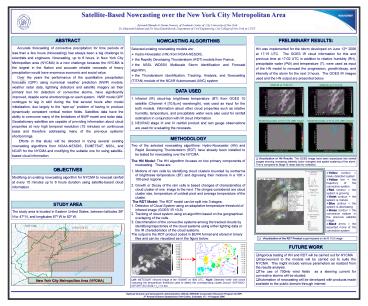
HN was implemented for the storm developed on
June 12th 2006 at 1715 UTC. The GOES IR cloud
information for this and previous time at 1702
UTC in addition to relative humidity (RH),
precipitable water (PW) and temperature (T), were
used as input of the HN model to nowcast the
progression, growth/decay, and intensity of the
storm for the next 3 hours. The GOES IR images
used and the HN output are presented below.
GOES IR, at 1702 UTC
GOES IR, at 1715 UTC
DATA USED
- Infrared (IR) cloud-top brightness temperature
(BT) from GOES 10 satellite (Channel 4 10.8?m
wavelength), was used as input for the both
models. Information about other cloud properties
such as relative humidity, temperature, and
precipitable water were also used for rainfall
estimation in conjunction with IR cloud
information. - NEXRAD stage III and IV rainfall product and rain
gauge observations are used for evaluating the
nowcasts.
Rainfall Nowcastes, at 1815 UTC (after 1-hour)
Rainfall Nowcastes, at 1915 UTC (after 2-hours)
METHODOLOGY
- Two of the selected nowcasting algorithms
Hydro-Nowcaster (HN) and Rapid Developing
Thunderstorm (RDT) have already been installed to
be tested for nowcasting over the NYCMA. - The HN Model The HN algorithm focuses on two
primary components of nowcasting. These are - Motions of rain cells by identifying cloud
clusters bounded by isotherms of brightness
temperature (BT) and dignosing their motions in a
100 x 100-pixel regions - Growth or Decay of the rain cells is based
changes of characteristics of cloud cluster of
one image to the next. The chnges considered are
cloud cluster size, temperature of coldest pixel
and average temperature of the cluster. - The RDT Model The RDT model can be split into 3
stages - Detecton of Cloud System using an adaptative
temperature threshold of infrared image (GOES IR
10.8) - Tracking of cloud system using an algorithm based
on the geographical overlaping of the cells. - Discrimination of the convective systems among
the tracked clouds by identifying trajectories of
the cloud systems using either lighting data or
the IR characteristics of the cloud systems. - The output is the RDT product coded in BUFR
format and stored in binary files and can be
visualized as in the figure below.
- Visualization of HN Results. The GOES image have
been reproduced into rainfall images showing
increasing intensity (color changes) and spatial
scatering of the storm. This is compared to
Stage III radar data for validation.
OBJECTIVES
- Yellow contour newly detected system
- Yellow line the trajectory of the convective
system. - Red contour the system is growing
- Violet contour the system is mature.
- Blue contour the system is decreasing.
- Green contour the convective system in the
previous satellite image. - Black arrow the expected move of the convective
system
Modifying an existing nowcasting algorithm for
NYCMA to nowcast rainfall at every 15 minutes up
to 6 hours duration using satellite-based cloud
information.
STUDY AREA
The study area is located in Eastern United
States, between latitudes 36º N to 47º N, and
longitudes 67º W to 82º W.
- Visualization of the RDT Product superimposed
on its IR.10.8 image
FUTURE WORK
- Vigorous testing of HN and RDT will be carried
out for NYCMA - Improvement to the models will be carried out to
suite the NYCMA. This might include various
parameters as realized from the results analysis. - The use of 700mb wind fields as a steering
current for convective storms will be studied. - Automation of nowcasting will be developed with
products made available to the public domain
through internet
New York City Metropolitan Area (NYCMA)
Left METEOSAT infrared image of the 15/08/97 at
1800 UTC Right Detected cells with colors
indicating the temperature threshold used to
detect the corresponding cluster.Source
SAF-NWC-IOP-MFT-SCI-SUM-11_v1.0.doc
National Oceanic and Atmospheric Administration
(NOAA/ NESDIS) Cooperative Research Program
(CoRP) 3rd Annual Science Symposium, Fort Colins,
Colorado, 15 16 August 2006


![5 Big Data Analytics tools [2020] PowerPoint PPT Presentation](https://s3.amazonaws.com/images.powershow.com/9449441.th0.jpg?_=20200605056)


