
Working with CADD Files - PowerPoint PPT Presentation
1 / 18
Title:
Working with CADD Files
Description:
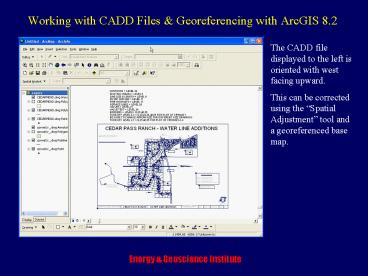
The CADD file displayed to the left is oriented with west facing upward. ... The 'Affine' option is used where the data being adjusted are spatially accurate ... – PowerPoint PPT presentation
Number of Views:26
Avg rating:3.0/5.0
Title: Working with CADD Files
1
Working with CADD Files Georeferencing with
ArcGIS 8.2
The CADD file displayed to the left is oriented
with west facing upward. This can be corrected
using the Spatial Adjustment tool and a
georeferenced base map.
2
Working with CADD Files Georeferencing with
ArcGIS 8.2
To Begin, using the main pull-down menu, select
Tools and then Customize. The form shown
below will be presented. Check Spatial
Adjustment.
3
Working with CADD Files Georeferencing with
ArcGIS 8.2
Data must be viewed at full extent. Two CADD
files are shown. The lower-left data are not
georeferenced. The upper-right data are. The CADD
files must then be exported as shape files.
To export, left-click on the file of choice, the
right click to view the context menu
4
Working with CADD Files Georeferencing with
ArcGIS 8.2
With the context menu open, select Data ?
Export Data. You will then be prompted for a
path and shape file name. The new shape files
will be added to your map document table of
contents. The CADD files can then be removed.
5
Working with CADD Files Georeferencing with
ArcGIS 8.2
Using shape files, select Start Editing from
the Editor tool bar.
6
Working with CADD Files Georeferencing with
ArcGIS 8.2
Now set Snapping using the Editor pull-down
menu.
7
Working with CADD Files Georeferencing with
ArcGIS 8.2
Now Zoom in on the map to georeference and
locate ground control.
8
Working with CADD Files Georeferencing with
ArcGIS 8.2
Zoom to a ground control point and select the
Displacement Link tool on the Spatial
Adjustment tool bar.
9
Working with CADD Files Georeferencing with
ArcGIS 8.2
Drag the Displacement Link tool over your
ground control point. With Snapping on it
should stick to the point. Left-click the mouse
and your first link is started.
10
Working with CADD Files Georeferencing with
ArcGIS 8.2
Now zoom out to full extent.
11
Working with CADD Files Georeferencing with
ArcGIS 8.2
Zoom in on the same ground control point on a
georeferenced map. Click the Displacement Link
tool on the point to finish the link.
12
Working with CADD Files Georeferencing with
ArcGIS 8.2
Complete 10 or 12 links spread over the entire
area of the file to be georeferenced. If rubber
sheeting more points will be necessary.
13
Working with CADD Files Georeferencing with
ArcGIS 8.2
Now check options using the Spatial Reference
pull-down menu (this can be done anytime prior to
adjustment). The option shown to the left allow
file selection for adjustment
14
Working with CADD Files Georeferencing with
ArcGIS 8.2
Transformation type options. The Affine option
is used where the data being adjusted are
spatially accurate but need to be rotated.
Additionally, the links can be saved to a file.
15
Working with CADD Files Georeferencing with
ArcGIS 8.2
Table fields can be chosen for attribute
transfer. After all options are set select
Adjust.
16
Working with CADD Files Georeferencing with
ArcGIS 8.2
After the adjustment, the map should overlay the
reference map. The old map on the lower-left has
disappeared.
17
Working with CADD Files Georeferencing with
ArcGIS 8.2
The north arrow is now pointing north. The
georeferenced image now must be saved to a new
shape file and the task in complete.
18
Working with CADD Files Georeferencing with
ArcGIS 8.2
Shape files produced from CADD files are
generally not Thematically Clean. Logical
layers can be extracted using queries and saved
ad shape files.
Recommended
CrystalGraphics Presentations


