Atmospheric poleward energy transport by eddy circulation 6'3'3 - PowerPoint PPT Presentation
1 / 11
Title:
Atmospheric poleward energy transport by eddy circulation 6'3'3
Description:
Atmospheric energy transport in the midlatitudes is accomplished mainly by eddy circulations ... Zonal and time mean northward transport of temperature ... – PowerPoint PPT presentation
Number of Views:106
Avg rating:3.0/5.0
Title: Atmospheric poleward energy transport by eddy circulation 6'3'3
1
Atmospheric poleward energy transport by eddy
circulation (6.3.3)
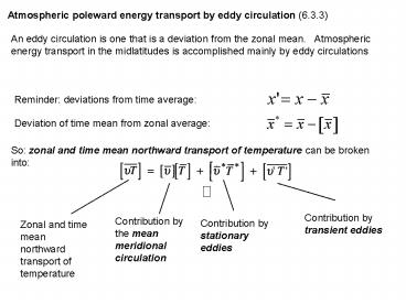
An eddy circulation is one that is a deviation
from the zonal mean. Atmospheric energy
transport in the midlatitudes is accomplished
mainly by eddy circulations
Reminder deviations from time average
Deviation of time mean from zonal average
So zonal and time mean northward transport of
temperature can be broken into
Contribution by transient eddies
Contribution by the mean meridional circulation
Contribution by stationary eddies
Zonal and time mean northward transport of
temperature
2
Stationary eddies are caused by zonal
inhomogeneity on the earth surface (e.g.
land-ocean contrasts mountains) Example
average height of the 500mb pressure surface
during January in the Northern Hemisphere.
Contour interval is 100m
3
Transient eddies such as storms and larger scale
undulations in the flow evolve over space and
time. They are prevalent in the midlatitude
westerlies where they are generated by a process
called baroclinic instability. The instability
draws its energy from the mean available
potential energy - in this case, the meridional
temperature gradient - to feed the disturbance.
4
Schematic of streamlines (solid) and isotherms
(dashed) associated with a large-scale
atmospheric disturbance in the Northern
hemisphere midlatitudes
Note that vT gt 0 in all instances, so that
energy is transported northwards by these eddies
5
Zonal mean northward flux of temperature by
stationary and transient eddies
Note that while the flux in the NH changes
dramatically from NH winter to summer, the SH
flux remains roughly the same magnitude both
summer and winter
6
Atmospheric energy transport breakdown by season
and by the mean meridional and eddy circulations
Northward transport by mean meridional
circulation - dominates in the tropics
Northward transport by eddy circulation -
dominates in the midlatitudes
7
Breakdown into potential, sensible, and latent
energies (ve northward)
Mean meridional circulation
Eddy circulation
NOTE we didnt go over this slide in class, but
the upshot of this slide is this that the
transport of potential energy dominates the total
transport of energy by the MMC, whereas the
transport of sensible energy dominates the total
transport of energy by the eddies
Potential
sensible
latent
total
8
Breakdown of the annual and zonal mean northward
energy flux into the mean meridional circulation,
total eddy and transient eddy
Note equatorward transport for MMC in the
midlatitudes (Ferrel cell) Relative contribution
of transients to the total eddy transport
9
Polar Cell Ferrel Cell
The Ferrel cell is a residual circulation - it
comes as a consequence of the stationary and
transient eddy circulations in the midlatitudes.
The warmer midlatitude Ferrel cell meets the
colder polar cell at the polar front, where it
lifts over the denser polar air. The Polar
cell subsides over the poles where it acts to
warm the atmosphere there (to balance the
radiative cooling). Hence dry, high pressure
conditions (polar high). The air moves back to
the midlatitudes in lower troposphere (as polar
easterlies).
10
The polar front creates pressure gradients that
give rise to the midlatitude jet (aka polar jet).
They can be 100 km/h or faster
11
- Regional circulation comments on the movies
(from the U Oregon geog dept. and other websites) - Sea level pressure and surface winds notice the
low pressure zones in the tropics and high
latitudes (in the NH, they are the Aleutian low
in the Pacific, and the Icelandic low in the
Atlantic) and the high pressure zones in the
subtropics. Note correspondence between pressure
and winds. Notice also the seasonal evolution -
in particular, the strengthening of the NH
subtropical high in summer, and the NH high
latitude low in winter. Note also the contrast
in sea level pressure between the land and ocean
in the NH summer and winter. - 500mb omega (pressure vertical velocity)
positive values mean subsidence. Note the
land-sea constrast in the tropics and subtropics,
and the seasonal migration in the tropics. Also,
the upward velocity in the high latitudes. How
is omega and tropical convection related? And
with sea level pressure? - 500mb height and winds since we are looking at a
constant (500mb) pressure surface, gradients in
height are related to the wind. Notice how much
more zonal it is , and how less it cares about
the land-sea contrast (but note how the height
and flow become less zonal in NH winter on the
eastern end of North America and Asia and also
the contrast between the NH and SH in this
respect). Notice also the seasonal evolution, in
particular the latitude of maximum height
gradients, and its strength. Can you spot the
subtropical/midlatitude westerlies? The
easterlies in the tropics? How does the winds
relate to the height?


