GPS - PowerPoint PPT Presentation
1 / 11
Title:
GPS
Description:
Study location: Lost Hills Water District, Kern County, CA. ... Spray Coupe. GPS. Hydraulic. soil sampler. Laptop. Mobile Conductivity Assessment System (MCA) ... – PowerPoint PPT presentation
Number of Views:19
Avg rating:3.0/5.0
Title: GPS
1
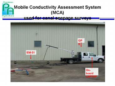
Mobile Conductivity Assessment System (MCA) used
for canal seepage surveys
GPS
EM-31
On-board LAPTOP
2
Canal survey (Losthills)
3
EM-31
4
(No Transcript)
5
(No Transcript)
6
Canal surveys
- Study location Lost Hills Water District, Kern
County, CA. (Unlined section area 5 North ditch,
about 3,700 ft long). - Study period August 2001 when canal was open.
- Canal surveys A Mobile Conductivity Assessment
(MCA) System was developed that comprised four
components mounted on a truck (1) an
electromagnetic induction sensor EM-31, (2) a
global positioning system (GPS) receiver, (3) a
computer, and (4) a hydraulic soil sampler (Fig.
1). The EM sensor was placed in a plastic
carrier-sledge attached to the rear of the truck
and measured the depth-weighted apparent soil EC
down to 10 ft. The EM and GPS instruments were
connected via digital interfaces to an on-board
laptop computer that simultaneously recorded the
EM readings and their corresponding GPS locations
using a Salinity surveyor software (US
Positioning, NM).
7
Canal surveys (cont.)
- Electromagnetic induction principle the EM
transmitter coil induces an electromagnetic field
in the ground, which in turn creates a secondary
magnetic field that is measured by the receiver
coil. The ratio of both fields provides a
measure of the depth-weighted apparent electrical
conductivity (EC) in a volume of soil below both
coils. Since EC of a soil is a function of its
water content, salt content, texture, use of the
EM technique can be very valuable for canal
seepage assessment. - Data calibration and analyses using ESAP-95
statistical package following ground-truthing
soil sampling (0-8 ft). Soils were analyzed for
EC, bulk density, water content, and texture. - Output data Contour maps of soil EC and water
content, and clay content using ArcView GIS.
8
Mobile Conductivity Assessment System
(MCA) used for salinity surveys
GPS
Laptop
EM-38 placed in a plastic sled
Hydraulic soil sampler
Spray Coupe
9
Geonics EM-38 Dual Dipole Conductivity Meter
Unit in vertical dipole mode
Unit in horizontal dipole mode
Serial RS232 digital interface to connect EM
meter and computer
10
Salinity distribution 0-1 ft (1st field)
11
Salinity distribution 0-1 ft (2nd field)


