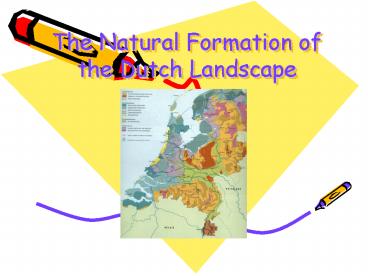
The Natural Formation of the Dutch Landscape - PowerPoint PPT Presentation
1 / 12
Title:
The Natural Formation of the Dutch Landscape
Description:
8000 2,5 billion years ago = Pleistocene ('Period with glacials and ... ( Mammoth) Humans started to influence natural environment. Peat bogs (or peat basis) ... – PowerPoint PPT presentation
Number of Views:23
Avg rating:3.0/5.0
Title: The Natural Formation of the Dutch Landscape
1
The Natural Formation of the Dutch Landscape
2
Formation of the earth
- The earth is 4.5 billion years old.
- The history of the earth is divided into epochs
geological timescale. - 0 8000 year Holocene
- 8000 2,5 billion years ago Pleistocene
(Period with glacials and interglacials) - The Dutch surface is mainly formed in these two
epochs.
3
Law of Superposition
- Sediments are always deposited on top of each
other. Therefore the higher, the younger. - The Netherlands has had different climates. This
is due to the movements of the plates over the
world (view BA 52 / 175. - The Netherlands has always been an area of
sedimentation.
4
Kinds of sedimentation
- Marine sea
- Aeolian wind
- Fluviatile river
- Glacial ice
- Fluvioglacial meltwater
- Organic plants and animals
5
Picture 1
- During Carbon uplift of South Limburg, forming
of relief. - Pre-Saale period fluviatile sediments
- During colder periods the sea level dropped,
because large amounts of ocean water was locked
up as ice. River mouths were more to the West
than presently. - The rivers Maas and Rhine were depositing gravel
and sand during cold periods. - In some parts up to hundreds of metres.
6
Why do ice ages occur?
- Different theories
- Continents move over the earth. Warm or cold
ocean currents can suddenly cause a temperature
difference. - Volcanic activity many ash particles in the air,
blocking the sunlight. - Difference in the position of the earth to the
sun.
7
Picture 2
- Ice age Saale glacial important. Hardly any
vegetation. - Ice came from Scandinavia.
- Ice reached until the HUN line Haarlem Utrecht
Nijmegen. - Push moraines were formed, as well as ground
moraines (till / boulder clay). - Problems with impermeability.
- Forming of outwash plains and urstromtäler in
less cold periods. - Ice followed the dried-up river valleys.
- Ice retreated in phases, forming low push
moraines in for example Drenthe. - Saale land ice pushed the Rhine near Nijmegen to
a different course, it has a twist to the West.
8
Picture 3
- After Saale glacial, Eemien, interglacial. Rise
in temperature rise in sea level deposit of
large amounts of sediments (sand and clay). - Weichsel glacial cold, but land ice did not
reach The Netherlands. - Polar desert, permafrost scarce vegetation.
- Aeolian sand deposits loess in South Limburg.
- End of Pleistocene more vegetation sand was
trapped river dunes.
9
Picture 4
- Holocene comes in higher temperatures,
transgression (fast rise of sea level) more
vegetation inundations. - Absolute rise of the sea level heating of the
sea water melting of ice. - Relative rise of sea level Weight of ice
caused a crustal depression near Scandinavia
uplift of The Netherlands. Holocene melting of
ice Scandinavian land surface rebounded The
Netherlands moved downwards again. - Holocene is a regular interglacial, but
- Large mammals died out. (Mammoth)
- Humans started to influence natural environment.
- Peat bogs (or peat basis)
- Ordinary peat bogs by rainwater
- Raised peat bogs by ground water
10
Picture 5
- Lots of peat basis was washed away.
- The coast turned into a waddengebied.
- Marine sedimentations old blue sea clay.
- North Netherlands impermeable till at the
surface forming of raised peat bogs. - Central Netherlands fluviatile sedimentation
- River landscape sand particles accumulated along
edges of river ridges of elevated land built up
on either side of the river natural levees. In
lower-lying areas outside the levees (backlands)
finer clay particles were deposited. - Presently the levees are relatively higher in the
landscape due to the settling of the clay in the
backlands.
11
Picture 6
- 5000 years ago Forming of beach-ridges en dunes
- Beach-ridges sand bodies along the coast. Not
too high, inundate frequently. - Forming of old dunes.
- Geestgronden old dunes were digged off for the
production of tulip bulbs.
12
Picture 7
- 1000 1200 yrs. after Chr. Forming of young
dunes. - Lots of erosion (due to deforestation). Lots of
sand became available. - Aeolian sediments young dunes
- Young marine sediments
- Cutting of peat areas
- Humans start to intervene

