SEBASS Airborne Platforms - PowerPoint PPT Presentation
1 / 5
Title:
SEBASS Airborne Platforms
Description:
2,000 - 12,500 ft altitude 20,000 - 65,000 ft altitude ... Direct downlooking Down and oblique views. Pushbroom nadir scan Backscanned whiskbroom ... – PowerPoint PPT presentation
Number of Views:21
Avg rating:3.0/5.0
Title: SEBASS Airborne Platforms
1
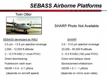
SEBASS Airborne Platforms
Twin Otter
SHARP Photo Not Available
- SEBASS developed as IRD SHARP
- 3.0 µm - 13.6 µm spectral coverage 3.0 - 13.6
µm spectral coverage - 2,000 - 12,500 ft altitude 20,000 - 65,000 ft
altitude - 2 - 12.5 ft GSD (1 mrad IFOV) 2 - 6.5 ft GSD
(100 µrad IFOV) - Direct downlooking Down and oblique views
- Pushbroom nadir scan Backscanned whiskbroom
- NESR 0.4 - 0.7 µflicks NESR 0.1 - 1
µflicks - (depends on aircraft speed) (depends on
mirror scan rates)
2
SEBASS
- Capabilities
- MWIR/LWIR Hyperspectral Imager
- Airborne day/night capability
- Gas identification
- Solid material identification
- Precision thermometry T 0.01C
- Extrapolated to space system design
- Utilization
- Surveillance / Remote Sensing
- Gas effluent detection
- Geological / mineral mapping
- Battlespace characterization
3
SEBASS Systems
AHI Twin Otter - Low Altitude
Analysis Center
Ground Based Mobile
4
SHARP
- High fidelity measurement instrument
- Calibrated, low noise, well characterized
- Addresses signature phenomenology
- Background false alarm statistics
- Atmospheric path effects (mean and variance)
- Broad in situ signature database development
- Sensor and algorithm performance limits
Spatially Enhanced Broadband Array Spectrograph
System (SEBASS) High Altitude Research Project
(SHARP)
- Supports many operational scenarios
5
A SEBASS Literature Reference
Hackwell, J. A., Warren, D. W., Bongiovi, R. P.,
Hansel, S. J., Hayhurst, T. L., Mabry, D. J.,
Sivjee, M. G., and Skinner, J. W. (1996).
LWIR/MWIR Imaging Hyperspectral Sensor for
Airborne and Ground-Based Remote Sensing. Imaging
Spectrometry II, Proceedings of the International
Soc. for Optical Eng., Vol. 2819102-107.


