3D High-Resolution GIS Taiwan Platform - PowerPoint PPT Presentation
1 / 11
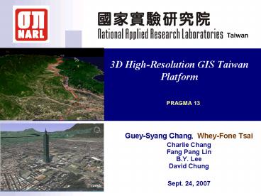
Title: 3D High-Resolution GIS Taiwan Platform
1
3D High-Resolution GIS Taiwan Platform
Taiwan
PRAGMA 13
- Guey-Syang Chang, Whey-Fone Tsai
- Charlie Chang Fang Pang LinB.Y. LeeDavid Chung
- Sept. 24, 2007
2
Introduction
The first remote sensing satellite FORMOSAT-2,
was successfully launched on May 21, 2004
The images captured by FORMOSAT-2 during daytime
is 2 meter resolution
High-Resolution (2m, 5m)
3D GIS Taiwan Platform
5 meter Terrain Elevation Data Surveyed by
Ministry of Interior
3D VR GIS Taiwan
3D Web GIS Taiwan
Optical Multi-Spectrum Air Borne Image is
available on demand 20cm Resolution Image
3
FORMOSAT-2 Daily Revisit Capability
FORMOSAT-2 Daily Images can be used for
monitoring Disaster Event
4
The I-35W Bridge over the Mississippi in
Minneapolis collapsed on August 1, 2007, was
real-time acquired by FORMOSAT-2.
5
The Mission
Observatory Platform
Simulations Applications
NSPO Remote Sensing Images
NCTFR Typhoon Flood
ITRC Air Borne Image
NCREE Earthquake Engineering
NARL
Data Processing
NCHC, HPC Resources
Sensor Network Grid
NCDR Disaster Monitoring Reduction
3D Visualization
6
The Goal
Support for Decision Making on Disaster
Management
Access Grid
Multi Media
Communications
Presentation
Auxiliary Information
3D VR GIS Taiwan
Real-Time Sensor
Sensor Network
Archived Image/data
4K Projector Resolution
7
CorrespondingReal-time Sensor and Data/Table
Image from Formosat-2 (Remote Sensing Data)
8
Web-based 3D GIS Taiwan Progress
River Monitoring Sensor Coupled with 3D GIS
Environment
TeleScience
GeoScience
Control tool bar of 3D GIS Environment for Sensor
Node
9
The DEMO High Resolution 3D GIS Taiwan
- Satellite Image
- Resolution 2m
- Total size 33GB
- Digital Terrain Model
- Resolution 5m
- Cover an area of 36,000 km2
- Grid/mesh size 40,388 X 75,526
- Triangulation 6 billion triangles
Taipei-101B
Hsinchu-NCHC-N
Taichung-NCHC-C
HualienTa-Ro-Ko
Tainan-NCHC-S
Taitung
Kao Hsiaung
- 3D GIS Taiwan Display
- Language Open-GL
- Volume Rendering
- Discrete Level-Of-Detail
10
Remarks
- SC 2007 Reno
- NCHC booth Demo 3D VR (Stereo) GIS Taiwan
- PRAGMA 14 (Taiwan)
- 4K-Projector 3D VR (Stereo) GIS Taiwan ready
- 3D High-Resolution GIS Taiwan Platform
- 2009 Official NARL Multi-Institute Integrated
Project
11
Thank you for Your Attention


