
Surveying Seismic Microzonation in Urban Areas - PowerPoint PPT Presentation
1 / 47
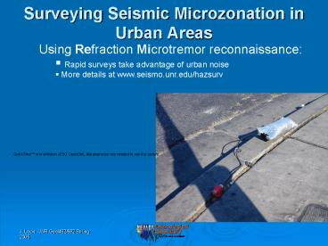
Title: Surveying Seismic Microzonation in Urban Areas
1
Surveying Seismic Microzonation in Urban Areas
- Using Refraction Microtremor reconnaissance
- Rapid surveys take advantage of urban noise
- More details at www.seismo.unr.edu/hazsurv
2
Refraction Microtremor for Shallow Shear Velocity
Surface waves show different velocities at
different frequencies but only after some
distance.
Initial funding from SCEC, UNR, VUW, Optim LLC
3
Refraction Microtremor for Shallow Shear Velocity
ReMi measures Rayleigh dispersion with linear
refraction arrays (paper by Louie, April 2001
BSSA).
The array has to have at least 12 channels 150 m
length and recorded for 4 sec (for 30-m depth
resolution and 1-Hz frequency resolution).
Initial funding from SCEC, UNR, VUW, Optim LLC
4
Refraction Microtremor for Shallow Shear Velocity
City traffic gives appropriate 4-16 Hz signal.
Initial funding from SCEC, UNR, VUW, Optim LLC
5
Refraction Microtremor for Shallow Shear Velocity
A wavefield transform from (x, t)-space to (p,
f)-space shows phase-velocity dispersion
(McMechan and Yedlin, 1981).
Initial funding from SCEC, UNR, VUW, Optim LLC
6
Refraction Microtremor for Shallow Shear Velocity
What if energy arrives transverse to the linear
array?
Initial funding from SCEC, UNR, VUW, Optim LLC
7
Refraction Microtremor for Shallow Shear Velocity
What if energy arrives transverse to the linear
array?
Initial funding from SCEC, UNR, VUW, Optim LLC
8
Refraction Microtremor for Shallow Shear Velocity
What is our low-frequency detection limit? Can we
use standard 4-16 Hz geophones that are easy to
deploy? Cluster-test microtremor records show we
get data down to 25-50 of the geophone frequency!
Initial funding from SCEC, UNR, VUW, Optim LLC
9
Refraction Microtremor for Shallow Shear Velocity
The minimum-velocity envelope represents the
Rayleigh fundamental-mode dispersion
curve. Kinematic data only, that we model for a
shear-velocity versus depth profile.
Initial funding from SCEC, UNR, VUW, Optim LLC
10
Refraction Microtremor for Shallow Shear Velocity
We dont invert for Vs(z), we forward-model
interactively by hand.
Initial funding from SCEC, UNR, VUW, Optim LLC
11
Refraction Microtremor for Shallow Shear Velocity
Fieldwork is quick and simple best results in
cities.
Initial funding from SCEC, UNR, VUW, Optim LLC
12
Refraction Microtremor for Shallow Shear Velocity
Fieldwork is quick and simple best results in
cities.
Initial funding from SCEC, UNR, VUW, Optim LLC
13
Refraction Microtremor for Shallow Shear Velocity
Low-frequencies, 1-20 Hz, so bad geophone plants
still work.
Initial funding from SCEC, UNR, VUW, Optim LLC
14
Refraction Microtremor for Shallow Shear Velocity
Low-frequencies, 1-20 Hz, so bad geophone plants
still work.
Initial funding from SCEC, UNR, VUW, Optim LLC
15
Refraction Microtremor for Shallow Shear Velocity
Fieldwork is quick and simple best results in
cities.
Initial funding from SCEC, UNR, VUW, Optim LLC
16
Refraction Microtremor for Shallow Shear Velocity
Fieldwork is quick and simple best results in
cities.
Initial funding from SCEC, UNR, VUW, Optim LLC
17
Refraction Microtremor for Shallow Shear Velocity
Fieldwork is quick and simple best results in
cities.
Initial funding from SCEC, UNR, VUW, Optim LLC
18
Refraction Microtremor for Shallow Shear Velocity
ReMi has classified hard and soft sites around
the world by measuring V30, average shear
velocity to 30 m depth.
19
Reno Transect
Local reconnaissance was first large-scale test.
Supported by UNR and IRIS-PASSCAL
20
Reno Transect
Unexpected results high V30 in active alluvium.
21
Reno Transect
Transect has results to 300 m depth, shown here
to 500 m. V30 is only the shallow part that the
IBC2000 requires measuring.
22
Reno Transect
Lack of V30 correlation to geologic or soil
maps. Only Tertiary Andesite (Ta) shows a
characteristic V30.
23
Reno Transect
Lack of V30 correlation to geologic or soil maps
24
Reno Transect
Basin info from 2000 gravity work.
25
Reno Transect
Most of basin fill is Tertiary.
26
The First Reno Hazard Map
27
We Follow Fields (2001) Amplification-Mapping
Strategy
28
Shallow Shear-Velocity Transects
July 2003 San Gabriel Valley Los Angeles
Transect mapped on NEHRP hazard class map by
Wills, from SCEC Phase 3 Report
Supported by USGS, NEHRP ERP and IRIS-PASSCAL
29
Los Angeles Transect
- Approximately 60 km in length
- Followed San Gabriel River Bike Path
- 20 m takeout interval, 300 m array, recorded for
30 min - 4 teams, 3 people each, 4.5 days
- 120 IRIS/PASSCAL Texan single-channel recorders
mated to a vertical 4.5-Hz geophone
Supported by USGS, NEHRP ERP and IRIS-PASSCAL
30
Los Angeles TransectLevee Effects
- V30 levee 245 m/s
- V30 non-levee 241 m/s
31
Los Angeles Transect Results
32
V30 vs Geologic Unit
- Large V30 variation inside each unit
- Large V30 variation between units
33
V30 vs Soil Type
- In general, large V30 variation within units
- Units 2 and 5 may be NEHRP D
- Large V30 variation between units
34
Shallow Shear-Velocity Transects
Las Vegas route from Cheyenne to Tropicana
3-km-deep basin
1-km-deep basin
Supported by DOE-LLNL and IRIS-PASSCAL
35
Las Vegas Transect Measurements
49 velocity profiles to correlate with
stratigraphy
36
Transect Data
High-velocity picks at gt0.4 sec period are
unreliable. Picks at 0.1-0.3 sec illustrate
velocity differences to 100 m depth.
37
Las Vegas Transect
Some correlation to faulting, soil type?
38
Geologic Info to Predict Vs
- Can soil maps predict Vs?
39
Does extrapolating Vs work?
- Vs assigned to soil-map units using central-City
measurements. - Later, outlying measurements (B. Luke, UNLV) not
predicted by maps.
40
Does extrapolating Vs work?
- Vs assigned to soil-map units using central-City
measurements. - Later, outlying measurements (B. Luke, UNLV) not
predicted by maps.
41
Las Vegas Transect
Most of Strip, Downtown south side of Valley
only 79 sites total 1000 well logs geologic
mapping
42
How to Extrapolate Shallow Vs
- Correlate 75 Vs measurements against
stratigraphic model. - Stratigraphy interpolated between gt500 water-well
logs.
43
Extrapolated vs. Measured
- Comparisons along Cheyenne-to-Tropicana transect.
44
Las Vegas Transect
No correlation between V30 and geologic map.
45
Las Vegas Transect
Correlation with clay soils, caliche in Las Vegas?
46
Summary
- ReMi allows rapid seismic shaking-hazard
classification, as required by IBC2000. - Long ReMi transects can geophysically
characterize spatial variations in shaking
hazard. - Mapped soil and geologic units do not reliably
predict the measured V30. - Our measurements suggest one can use river
gradients, Quaternary thickness, or alluvial fan
composition to predict shallow velocities.
47
Outreach
Example of public outreach Discoveries and
Breakthroughs Inside Science, news shorts funded
by AIP, AGU, etc.
KFSN-TV Fresno, CA KGBT-TV Harlingen, TX KJTV-TV
Lubbock, TX KTRK-TV Houston, TX KNBC-TV Burbank,
CA KNSD-TV San Diego, CA KQTV-TV St. Joseph,
MO KNTV-TV San Francisco, CA KRQE-TV Albuquerque,
NM KTSM-TV El Paso, TX KTVN-TV Reno, NV KWQC-TV
Davenport, IA KXAS-TV Fort Worth, TX WAGM-TV
Presque Isle, ME WTEN-TV Albany, NY WCAU-TV
Philadelphia, PA WCMH-TV Columbus, OH WCYB-TV
Bristol, VA WEWS-TV Cleveland, OH WFTS-TV Tampa,
FL WLUK-TV Green Bay, WI WBBH-TV Fort Myers, FL
WHIO-TV Dayton, OH WIS-TV Columbia, SC WJAR-TV
Cranston, RI WLBT-TV Jackson, MS WMAQ-TV
Chicago,IL WNBC-TV New York, NY WNCN-TV Raleigh,
NC KTSM-TV Omaha, NE WPBN-TV Traverse City,
MI WSYM-TV Lansing, MI WTVJ-TV Miami, FL WVIT-TV
Hartford, CT WVTM-TV Birmingham, AL WXYZ-TV
Southfield, MI WJXT-TV Jacksonville, FL WTXL-TV
Tallahassee, FL WIVT-TV Binghamton, NY WEVV-TV
Evansville, IN WCJB-TV Gainesville, FL WPXI-TV
Pittsburgh, PA CHAT-TV Medicine Hat, ALB
K. Heineman, NewsProNet, Producers
Technology Transfer Commercial ReMi is now in
use by geotechnical consultants and agencies
worldwide.
Recommended
CrystalGraphics Presentations


