Changes in Weather - PowerPoint PPT Presentation
1 / 39
Title:
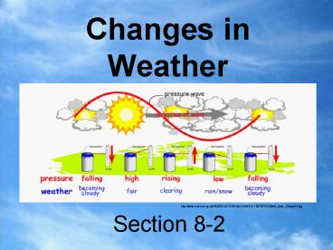
Changes in Weather
Description:
Occluded Front. Two cold air masses meet and force a warm air mass up in between them. ... occluded front - occurs when a faster moving cold front passes under a warm ... – PowerPoint PPT presentation
Number of Views:106
Avg rating:3.0/5.0
Title: Changes in Weather
1
Section 8-2
- Changes in Weather
http//www.sciences.gc.ca/8E2607CB-F2D8-40C5-B923-
971D0F6875C8/web_trans_changes2.jpg
2
Air Masses
- Changes in weather are caused by the development
and movement of large air masses - Air masses are constantly moving and swirling
over the surface of earth - During different times of the year different air
masses dominate the weather
http//videos.howstuffworks.com/hsw/23681-weather-
types-of-air-masses-video.htm
3
- Air Mass
- a large body of air where temperature and
moisture content is similar
- Examples
- One that develops over land is dry compared to
one that develops over water - One that develops near the equator is warmer than
one that develops at a higher latitude
http//www.weatherquestions.com/air_masses_AMSU.jp
g
4
Continental Arctic (cA)
http//www.uwsp.edu/geo/faculty/ritter/maps/air_ma
sses_2.jpg
- very cold very dry
5
Continental Antarctic (cAA)
http//www.uwsp.edu/geo/faculty/ritter/images/maps
/atmosphere/air_masses_small.jpg
- very cold very dry
- 60 and 90 south latitude.
6
Continental Polar (cP) air
http//www.csulb.edu/rodrigue/geog140/airmassbjer
knes.jpg
cold dry Typically a stable or conditionally
stable mass of air.
7
Continental Tropical (cT)
http//www.fas.org/irp/imint/docs/rst/Sect14/air_m
asses_2.jpg
warm dry Major source regions are the great
deserts of the Earth such as the Sahara, Arabian,
and Australian.
8
Maritime Equatorial (mE)
http//www.dask.org.tr/english/want_to_know/meteor
ology/air_masses/air_masses_2-new.jpg
very warm very moist
9
Maritime Polar (mP) air
http//www.dask.org.tr/english/want_to_know/meteor
ology/air_masses/air_masses_2-new.jpg
- cool moist
- Brings mild weather to coastal locations.
Maritime polar air is warmer than continental
polar air in the winter as the surface
temperature of the ocean is higher.
10
Maritime Tropical (mT) air
http//www.uwsp.edu/geO/faculty/ritter/maps/air_ma
sses_2.jpg
warm moist Responsible for much of the
precipitation east of the Rocky mountains in the
United States.
11
- Maritime Tropical Air Masses
- warm temperatures and rich in moisture
- originate over the warm waters of the tropics
and Gulf of Mexico, where heat and moisture
are transferred to the overlying air from the
waters below - northward movement of tropical air masses
transports warm moist air into the United States,
increasing the potential for precipitation
12
Air Masses of North America
http//www.fas.org/irp/imint/docs/rst/Sect14/airma
sses_schem.jpg
13
Fronts
- When an air mass moves and collides with another
air mass, a boundary forms between the two air
masses.
http//videos.howstuffworks.com/hsw/23683-weather-
air-mass-boundaries-fronts-video.htm
14
Warm Front
http//upload.wikimedia.org/wikipedia/commons/thum
b/1/1e/Weather_fronts.svg/500px-Weather_fronts.svg
.png
- Warm air rises and meets a cold air mass so
temperature falls and forms precipitation.
15
A warm front is a leading edge of warmer air.
16
Cold Front
- A cold air mass invades a warm air mass forcing
the warm air upward.
17
- cold front is an area of cooler air, not cold air
- possible to have cold fronts in the summer
- cold front often triggers storms
http//www.ecn.ac.uk/Education/cold_fronts.htm
18
Comparing Warm and Cold Fronts
http//www.classzone.com/books/earth_science/terc/
content/visualizations/es2002/es2002page01.cfm?cha
pter_novisualization
19
Stationary Front
- - A stationary front is an air mass that is not
moving - - Cold air mass meets warm air mass and doesnt
move
20
Occluded Front
- Two cold air masses meet and force a warm air
mass up in between them.
http//www.windows.ucar.edu/earth/Atmosphere/image
s/occluded_front_sm.jpg
http//www.physicalgeography.net/fundamentals/imag
es/occludedfront.GIF
21
occluded front - occurs when a faster moving cold
front passes under a warm front, and catches up
to another cold front
http//www.cartage.org.lb/en/themes/Sciences/Earth
science/Hydrology/Meteorology/AirMasses/Fronts/Occ
ludedFront/ofdef1.gif
22
Pressure Systems
- Difference in pressure affect the weather
23
High Pressure
- usually clear weather, air molecules are densely
packed - as cool, dense air sinks it becomes warmer
- when it warms, it can hold more moisture
- droplets of water from clouds evaporate into
warmer air
http//www.animationfactory.com/en/search/close-up
.html?oid4950964s1sc1st663qhigh20pressu
respage1hoid34f244b0ec38fbac1aa13ac92581657b
24
http//www.whistlerweather.org/uploaded_images/P80
10089-769007.JPG
http//www.whistlerweather.org/uploaded_images/P80
10089-769007.JPG
25
Low Pressure
- usually cloudy weather, air molecules are less
densely packed - as warm, less dense air rises, it cools
- cold air cant hold as much moisture, so water
droplets become clouds. - causes most of the weather changes in the US
http//www.animationfactory.com/en/search/close-up
.html?oid4950656s1sc1st195qlow20pressur
espage1hoid8248cdcf4d0c5d164d55a4ea816297ec
26
http//z.about.com/d/weather/1/0/l/-/-/-/precipsym
bols.gif
27
Wind Barbs Show Wind Direction and Speed in Knots
- Barbs point to direction wind is coming from. (1
Knot 1.15 mph)
http//www.scalloway.org.uk/images/knots.gif
28
http//www.rap.ucar.edu/weather/info/wind_barb.gif
29
Cloud Cover in a Weather Station Model
- Weather station model symbols used to indicate
cloud cover. - National Science Foundation
http//z.about.com/d/weather/1/0/R/-/-/-/cloudcove
r.gif
30
Weather Map Symbol
http//www.hpc.ncep.noaa.gov/images/plotstation.gi
f
31
Weather Map Symbols
http//dstreme.comet.ucar.edu/extras/wxsym2.html
32
Thermometers
- Measures temperature
http//www.oregongadgets.com/images/prods/RGR126p.
gif
http//img.alibaba.com/photo/50571760/Sell_Garden_
Thermometers.jpg
http//gidesigns.net/garden-decor/files/images_bac
kup/d_747.jpg
http//www.world-shop1.com/images/medical/digital
20thermometers20EBT-1.jpg
http//www.mercuryinyourhome.com/images/DigitalThe
rmometers.jpg
http//www.dzwholesale.com/Galileo_Thermometer_38c
m.jpg
33
Barometers
- Measures atmospheric pressure
http//www.treasurequestshoppe.com/images/Tabletop
Weatherglass.jpg
http//img.nauticexpo.com/images_ne/photo-g/digita
l-barometer-50659.jpg
http//www.weathershop.co.za/Dialbarometers/45_100
2pic.jpg
http//www.asiuk.net/rb5.jpg
http//cart.clockparts.com/images/W73GBI.jpg
34
Satellites
- Record air currents and cloud formation
http//www.thorntonweather.com/blog/wp-content/upl
oads/2008/12/goes-r.jpg
http//www.noaanews.noaa.gov/stories2005/images/no
aa-n.jpg
http//z.about.com/d/weather/1/0/q/0/-/-/TRMM_INST
.gif
http//www.newscientist.com/data/images/ns/cms/dn8
340/dn8340-1_590.jpg
35
Psychrometer
- Measures relative humidity
http//www.greenhousemegastore.com/images/sling-ps
ychrometer-100.jpg
http//ecx.images-amazon.com/images/I/5176E1S7H2L.
_SL500_AA280_.jpg
http//www.novalynx.com/225-sam.html
http//www.physicalgeography.net/fundamentals/imag
es/sling_psychrometer.jpg
36
Radar
- Is used to detect raindrops and ice particles up
to 400 kilometers away.
37
Radar Intensity Colors on a Weather Map
- Radar Echo Intensity shows the amount of
precipitation in an area by assigned a series of
colors to indicate heavy or light precipitation
including hail, rain, and snow. - NOAA National Weather Service
38
(No Transcript)
39
Bibliography
- "Cold Fronts." Environmental Change Network (ECN)
Home Page. The United Kingdom Environmental
Change Network. 17 Mar. 2009 lthttp//www.ecn.ac.uk
/Education/cold_fronts.htmgt. - Glencoe/McGraw-Hill Team. Teacher's for Use with
Science Interactions Course 3. 3rd ed. New York
Glencoe/McGraw-Hill, 1998. 80. - Opie, Alexandra. "Precipitation." All About Us.
Canterbury Broad Oak Environmental Education
Centre. 09 Mar. 2009 lthttp//www.econet.org.uk/wea
ther/ppt.htmlgt. - Ritter, Michael. "Air Masses." University of
Wisconsin-Stevens Point. University of
Wisconsin-Stevens Point. 22 Mar. 2009
lthttp//www.uwsp.edu/geO/faculty/ritter/maps/air_m
asses. - "The Water Cycle." Kidzone - Fun Facts for Kids!
1998-2009. Concordia University Saint Paul. 09
Mar. 2009 lthttp//www.kidzone.ws/water/gt.


