Rand - PowerPoint PPT Presentation
1 / 1
Title:
Rand
Description:
ATZ Class C (Aerodrome separation only) GND/6500ft ALT; ... Panorama Flight Park. Airspace. RAV (117.7 MHz) 26 14.7'S 28 09.2'E. J o h a n n e s b u r g C B D ... – PowerPoint PPT presentation
Number of Views:144
Avg rating:3.0/5.0
Title: Rand
1
WESBANK RAND AIRSHOW
Midrand, Pretoria ?
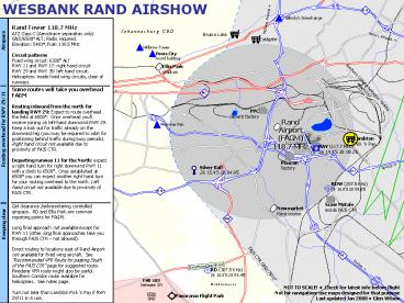
Rand Tower 118.7 MHz ATZ Class C (Aerodrome
separation only) GND/6500ft ALT Radio
required. Elevation 5483ft Fuel
130.5 MHz Circuit patterns Fixed wing circuit
6300ft ALT RWY 11 and RWY 17 right hand
circuit RWY 29 and RWY 35 left hand
circuit. Helicopters inside fixed wing circuits,
clear of runways
J o h a n n e s b u r g C B D
Bruma Lake
Benoni, Witbank ?
Eastgate
Airspace
Southern Corridor helicopter routing max 6000ft
Some routes will take you overhead FAGM Routing
inbound from the north for landing RWY 29 Expect
to route overhead the field at 6500ft. Once
overhead youll receive joining on left-hand
downwind RWY 29. Keep a look out for traffic
already on the downwind leg (you may be required
to orbit for positioning behind traffic during
busy periods). Right hand circuit not available
due to proximity of FAJS CTR. Departing runway
11 for the North expect a right hand turn for
right downwind RWY 11 with a climb to 6500ft.
Once established at 6500ft you can expect another
right hand turn for your routing overhead to the
north. Left hand circuit not available due to
proximity of FAJS CTR.
PPC cement factory
Rand Airport (FAGM) 118.7 MHz
Rand Airport (FAGM) 118.7 MHz
Routing overhead for RWY 29/11
Lambton Pick n Pay
RAV (117.7 MHz) 2614.7S 2809.2E
Springs ?
Silver Ball 2615.4S 2804.9E
RDW (287.5 KHz) 2616.0S 2809.8E
Get clearance before entering controlled
airspace. RD and Ellis Park are common reporting
points for FAGM. Long final approach not
available except for RWY 11 (other long final
approaches take you through FAJS CTR not
allowed). Direct routing to locations east of
Rand Airport not available for fixed wing
aircraft. See Recommended VFR Route for passing
South of the FAJS CTR page for suggested route.
Pinedene VFR route might also be useful.
Southern Corridor route available for
helicopters. See notes page. Turn not later
than Lambton Pick n Pay if RWY 29/11 is in use.
Keeping clear
FAJS CTR GND/7500ft
Durban ?
FAD 183 (helicopter GF) 6500 GND
B r a k e n h u r s t
NOT TO SCALE! Check for latest info before
flight Not for navigation use maps designed for
that purpose Last updated Jan 2008 Glen Wilson


![[PDF⚡READ❤ONLINE] Rand McNally Road Atlas Large Scale 2025: United States, Canada, Mexico (Rand PowerPoint PPT Presentation](https://s3.amazonaws.com/images.powershow.com/10049486.th0.jpg?_=202406070112)


