
PowerPointpresentasjon
1 / 7
Title: PowerPointpresentasjon
1
Field campaigns and data acquisitions in
Heimdalen, 2003
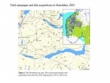
Figure 1. The Heimdalen test area. The in-situ
measurements were performed at the sites H01-H08,
ranging from 1100 to 1800 m asl.
2
In-situ snow measurements
Snow mobile
Documentation of snow roughness
Digging a snow shaft
3
Nedre Heimdalsvatn seen from Heimdalshø
Combining business and pleasure
Partially snow covered area
How deep do I need to dig?
4
Aerial campaign
- ESAR flight carried out succesfully on May 31,
2003 - Norut operated GPS-station, Corner reflectors and
in-situ measurements
5
Satellite acquisitions
ASAR was unavailable from ca. May 12 to June 8
due to a system malfunction
6
Processing of EnviSat ASAR data
Figure 7. Exampel Snow Covered Area mapping using
EnviSat ASAR WS in the Jotunhemen area.
Figure 6. Exampel geocoded EnviSat ASAR WS image
covering Southern Norway.
7
(No Transcript)
Recommended
CrystalGraphics Presentations


