
San Jacinto DUSEL - PowerPoint PPT Presentation
1 / 62
Title: San Jacinto DUSEL
1
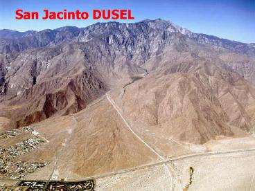
San Jacinto DUSEL
2
This Talk
- Mostly about the site and what we have learned
over the several years of investigation. - If time permits, unique science that can be done
at San Jacinto.
3
Philosophy
- Design and build a laboratory from scratch rather
than retrofit existing facility or share
facility. - No constraints imposed by conflicts with existing
operations. - Search for ideal location
- Year-round accessibility
- Convenient, pleasant location
- Proximity to Universities, industry and services
- Design ideal lab
- Low operational costs
- Convenient access
- Large depth
4
San Jacinto
- Search (Proctor- 1983) identified San Jacinto as
excellent site - Mt. San Jacinto is 3292 m high and is the second
highest peak in Southern California next to Mt.
San Gorgonio at 3507 m. - Steep escarpment allows for great overburden with
minimal tunnel length (depth up to 8,000 feet
with positive slope) - Geology of area well studied
- Competent, monolithic granitic rock
- Minimal seismic and faulting impact
- A lab with horizontal drive-in access is very
desirable. - Safety
- Ease of constructing and operating large
experiments - Drive-in access for standard road vehicles
- Low construction and operating costs
- Upgrade access tunnel will never flood
- Un-powered pedestrian escape
5
Depth Intensity
Super-K
Gran Sasso
SNO
San Jacinto
ERPM
6
San Jacinto
- Major urban area
- Commercial airports (Palm Springs, LAX, Ontario)
- Infrastructure (existing roads, commerce and
industry nearby) - Utilities (power, water, communications)
- Easy year-round access
- Hotels, restaurants, cultural activities
- Many High Energy Physics institutions nearby
7
San Jacinto
8
Location Airport Road Access
Ontario- IA
Burbank- RA
LAX- IA
Palm Springs- RA
Site Location
Orange County- IA
San Diego- IA
9
27 million people within 2 hour driving time from
Palm Springs Coachella Valley Interest general
public and students in science K-12 school
programs Large number of universities in
region Opportunity for graduate and undergraduate
training Inclusion in UCs network for minority
outreach and education
10
Palm Springs
11
Mountain Chino Canyon
12
Aerial View in Chino Canyon
Tramway Valley station
Portal Location
13
- 375,000 annual Tramway visitors
- Tramway plans a Joint Visitor Interpretive Center
- Biology of San Jacinto Mountain
- Physical science displays
14
Geology and Site Investigation
mid-Cretaceous age (90 to 100 million years ago)
batholith formed at depth
Metamorphic
Batholithic
Mountain is much younger - created by uplift
along the bounding faults in the late Pliocene (2
to 5 million years ago).
15
Major Rock Types
16
Desert Divide Group
Meta-sedimentary rocks of Late Pre-Cambrian to
Ordovician age
17
Batholithic Rocks
Mesozoic intrusive rocks tonalite
granodiorite with felsic dikes
18
Unprecedented rock access
- Exposed perimeter
- 50
- Extensive areas are bare outcrop
19
Snow Canyon North Side of Mountain
20
Idyllwild Southwest Side of Mountain
21
Rock Mass Properties
- SJ range is homogeneous mass of tonalite and
granodiorite.
22
Uniformity
Near Suicide Rock, Idyllwild
Hwy 111, Pine Cove
Black Mountain
Snow Creek Cyn
23
Lineament, Joint and Fault Study
- Lineament analysis, based on aerial photographs,
to provide an overview of structures that exist
in the rock. - Joint surveys to provide the detail about actual
joint orientations at sites around the mountain
and characteristics - tightness, continuity,
spacing planarity, roughness, infil. - Lineament analysis shows that faults do not come
through the San Jacinto structural block. - The lineament analysis also shows that within the
structural block there are two predominate joint
trends. - The joint surveys also showed that there is
little variation in these 2 joint systems as we
traversed across the mountain.
24
Extensive Survey of Joint Directions
25
Joint Directions
- 488 joints, 5 ft to gt 100 ft long
- 100 outcrops
- Primary jointing is perpendicular to San Jacinto
Fault and moderately inclined to the north
Joint and fault data support conclusion that rock
mass is unbroken by faulting. Rock mass
conditions can be estimated confidently where
tunnels are planned.
26
Potential Tunnel Alignments
27
Core Drilling
Within City Limits of Palm Springs
Tramway Property
28
Stakeholder Support
29
Recommendation of Appropriate Contingency
Recommend we increase total contingency to 30-50
given inflationary pressures on steel and
concrete.
30
Tunnel Schematic
- 3.83-meter radius TBM
- Concrete liner where necessary
- One tunnel inbound, one tunnel outbound
- Crosscuts every 500 meters
- 0 to 4 meter spacing near portal
- Enlarged spacing elsewhere for earth science
- Ventilation ducts, utilities, drainage
31
Profile Schematic
Additional earth science areas
32
Overburden at caverns
33
Underground laboratory complex
- Original costing
- experimental caverns 20x20x100 m
- Parking storage cavern
- Common area cavern
- Refuge cavern
- Sump fire reservoir
- Connecting egress tunnels
34
Underground Laboratory Complex
35
Utilities
- Access tunnel ventilation 115,000 cfm
- Separate cavern and connecting tunnel ventilation
95,000 cfm ducted and clean design for 200
person occupancy - Automatic dampers and air flow switching
- Emergency smoke ventilation 95,000 cfm
- Cooling load 2,000 tons
- tunnels lt80oF
- Caverns office temperatures
36
Utilities - continued
- All tunnels and caverns wet sprinkler and fire
pump system - Automatic fire detection alarm and communication
system - Domestic water and sanitary waste system
- 15 MVA electrical feeder
- generator back-up
- Power and communications distribution
- Lighting
- Closed circuit security system
- Card access system throughout
37
Environmental Issues
Design for minimal environmental impact
- Groundwater
- Biological
- Cultural
- Surface
38
Portal
39
Portal (close up)
40
Initial assessment conclusions
- all environmental effects resulting from the
implementation of the project can be addressed
through project design features or through
reasonable and feasible mitigation measures. - No environmental issues were identified that
would substantially affect the feasibility,
schedule, or budget for this project.
41
Permitting Process
- Preparing and publishing the initial CEQA/NEPA
solicitation for public comment (Notice of Intent
and Notice of Preparation) will require 45 to
60-days, including the 30-day public comment
period. - Joint CEQA/NEPA Environmental Impact
Report/Statement (EIR/S), can be completed and
readied for agency screencheck review within four
to six months of the initiation of the project.
We have assumed two review/amendment cycles of
45-days each, adding 90-days to the schedule. - This will allow the Draft EIR/S to be transmitted
for public comment within 7 to 9 months of
project initiation. An initial 60-day public
comment period is assumed, as is one 30-day
extension, bringing an end to the public comment
period 9 to 11 months following project
initiation. We have assumed 30-days to prepare
the Final EIR/S for adoption. Based on
discussions with the City, a joint hearing and
adoption by the Planning Commission and City
Council on the DUSEL and the EIR/S could occur
during month 12 to 14. - State and federal wildlife agencies have
indicated that they will work on Biological
Opinion Letters, MOUs and any other needed
permitting concurrent with the cooperative
finalizing of plans and the public review of the
project and EIR/S. This approach will allow
federal environmental clearances through the NSF
(assuming NSF is NEPA lead agency) during months
12 to 15. At this time, it is anticipated that
the City will issue the building permits to
construct the DUSEL.
42
Initial approval and design
43
Project Schedule
44
Global Earthquake Distribution (activity
concentrated at tectonic plate boundaries)
San Jacinto Site
Gran Sasso Site
Super-K Site
All 3 sites are located near tectonic plate
boundaries
Super-K and Gran Sasso experience subduction
generated seismicity San Jacinto (United States)
experiences strike-slip generated seismicity.
45
Comparing the number of medium large
earthquakes from 1994-2004
Super-K There was essentially no requirement for
seismic design for deep underground structures.
Acceleration amplitude due to earthquake at
-1000m was assumed to be about 1/3 of that at
surface.
Underground caverns not seriously influenced by
seismicity.
46
Seismically-induced Peak Ground Acceleration
(PGA) map for the state of California
Seismic design criteria for Kamioka, San Jacinto,
Gran Sasso, and SNO are similar 0.5g
47
Existing Seismic Monitoring Stations
Seismometers
EarthscopePlate Boundary Observatory
- 250 existing GPS stations - SCIGN
- 200 planned GPS- PBO
Plate Boundary Observatory (PBO)
Southern California Integrated GPS Network
(SCIGN)
48
Seismic Array
- Propose a dense array of seismic sensors at
depth. - The near-surface is the worst source of noise in
seismic recordings - it distorts the signal by scattering and
attenuation - it is the location of many noise sources - wind,
surf, culture, etc. - gt instrumentation in a deep hole in hard rock
provides a view of earthquakes with unprecedented
clarity.
49
Current Sensors
- Borehole deployments to date are simply a few
vertically aligned sensors - The geometry near San Jacinto will allow
horizontal - or perhaps a 2D or even 3-D seismic arrays, and
- the high station density proposed would provide
an order of magnitude improvement in the
redundancy that can be used to suppress noise. - gt improved geometry would be a more sensitive
antennae to characterize the seismic wave content
and propagation properties.
50
Targets of the Seismic Array
- The scaling of earthquake properties with
earthquake magnitude is a hot and unresolved
problem. This array would provide resolution of
many of the properties of small earthquakes, and
of a range of earthquakes at high frequencies. - An increasing number of continuously excited
sources are being identified, associated with
faults, volcanoes, subduction zones, and even
storms at sea. The proposed array could provide
grist for more such basic discoveries. - The proximity to the San Andreas fault provides
both earthquakes to study and structures that the
array could help to map and understand in
unprecedented detail.
51
Reactor Neutrinos
- Current best values for n1,n2 mixing are
- Sin22q12 0.82/-0.07, dm2 8.2/-0.6 x10-5 eV2
- There are suggestions to use real-time p-p flux
measurements to improve these results. - Another possibility use single reactor site.
- well known distance and power
Assume q13 will be known by then with small
uncertainty
52
San Onofre to San Jacinto
- Distance 100km
- Take dm28.0x10-5 eV2
- Take Sin22q120.8
- Take Sin22q231.0
Fraction of Event Rate Provided by Reactor Site
160 events/kt/y gt1MeV
2x3.4GW
53
Reactor ns at 100km
P(ne ne)
30 reduction at peak of n spectrum (4.0 MeV)
80 reduction at 6 MeV
Sin2 2q13 .1
Dm2128.0x10-5 eV2
Energy (MeV)
54
Sensitivity to dm122
55
Sensitivity
Calculation by Bob Svoboda
Current 95 c.l. region
dm2
Sin22q12
3 kt detector 5 years 22 kt detector 5
years
Order of magnitude improvement in parameters
56
Future Long Baseline Experiments
2700 km
3900 km
57
FermiLab to San Jacinto
- Distance 2700 m
- Look at nm ne nm ne as a function
- of sin2 2q13 and normal or inverse hierarchy.
58
Sin2 2q13 .01
Normal hierarchy
59
Sin2 2q13 .01
Inverted hierarchy
60
Can use BNL wide band beam approach or
Doug Michael proposal of combination of beams
using 8 geV proton driver and 120 GeV main
injector
First Max - On-axis wide band beam similar to
low-energy MINOS beam Second max off-axis using
120 GeV protons at 10-15mr. Third max use
on-axis 8 GeV proton beam
61
Probability vs CP Phase
Minakata Nunokawa hep-ph/0108085
62
Comparison With Shorter Baseline Potential
63
Summary
- Mt. San Jacinto was identified as optimal in the
early 1980s stressing benefits of horizontal,
drive-in access. - In 2001 and the past 18 months, we have invested
in further site investigation. - Principal findings and activities
- The escarpment is composed of high-quality,
well-exposed, well-studied rock, making possible
predictable, low-risk, low-cost underground
construction. - The thermal gradient is much less than estimated
in 2001, underground temperatures at maximum
depth 25º to 35ºC (77º-95ºF). This is very modest
for deep underground locations, and will
significantly lower our power requirements and
operating costs. - The project is constructable with current
technologies - Construction contingencies of 30 percent to 50
percent are appropriate, (only 5 percent for
geotechnical uncertainty) - Broken rock produced by construction could be
readily absorbed by local markets - Permitting for a test boring has begun
- Environmental and permitting issues are being
addressed and a clear permitting path has been
formulated. - Seismicity is the same or less than at existing
laboratories in Japan, Italy, and Canada and is
not an issue.
Recommended
CrystalGraphics Presentations


