
Plate Tectonics: The Unifying Theory - PowerPoint PPT Presentation
1 / 68
Title:
Plate Tectonics: The Unifying Theory
Description:
Plate Tectonics: The Unifying Theory – PowerPoint PPT presentation
Number of Views:565
Avg rating:3.0/5.0
Title: Plate Tectonics: The Unifying Theory
1
Plate TectonicsThe Unifying Theory
Peter W. Sloss, NOAA-NESDIS-NGDC
2
Plate Tectonics
- Chapter 2 in Press, Siever, Grotzinger and Jordan
- Fundamental concept of geoscience
- Integrates from many branches
- First suggested based on geology and paleontology
- Fully embraced after evidence from geophysics
3
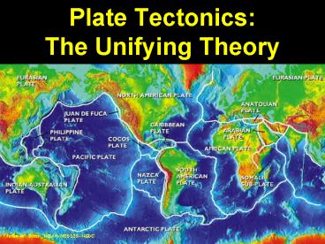
Mosaic of Earths Plates
Peter W. Sloss, NOAA-NESDIS-NGDC
4
Plates
- Group of rocks all moving in the same direction
- Can have both oceanic and continental crust or
just one kind.
5
Continental drift what evidence supports it1.
Fit of the Continents2. Plants and animals
match3. The rocks match4. Ice movement
matches5. Climates were different, positions do
not match
6
JOIDES Resolution
143 meters long, derrick 61.5 meters high, 65
crew, 50 scientists and techs
7
Gathering facts
8
Atlantis
274 feet, 17 feet draft, for ROV and
submersible. Crew 23, Scientist 24, Techs 13
9
RV Melville
279 feet long, draft 16.5 feet Crew 23, science
party 38
10
Dredging
11
Gathering facts
Water sampling
Seabeam
12
Formation of Magnetic Anomalies
13
Magnetic Anomalies
Fig. 20.9
14
Age of Seafloor Crust
R. Dietmar Muller, 1997
15
Types of plate boundaries
- divergent mid-ocean ridges
- convergent collision zones volcanic
arcs - strike-slip San Andreas fault Alpine fault,
N.Z.
16
Divergent plate boundaries
- Often start within continentsgrow to become
ocean basin - Responsible for break-up of continents
- Rifting often begins at a triple junction (two
spreading centers get together to form ocean
basin, one left behind).
Features of Mid Ocean Ridges
Central rift valley (morphology dependent on
spreading rate) Shallow-focus earthquakes
Almost exclusively basalt
Continental Rifts
Beginning of ocean formation (may not get that
far) East Africa, Rio Grande rift Rock types
basalt but also more exotic compositions
17
Types of boundaries
18
Rifting and Seafloor Spreading
Fig. 20.4a
19
Ocean floor
20
South West Indian Ridge detail
21
Inception of Rifting Within a Continent
Fig. 20.4b
22
Inception of Rifting Along theEast African Rift
System
Fig. 20.4b
Peter W. Sloss, NOAA-NESDIS-NGDC
23
Middle East
Nile Delta
Gulf of Aqaba
Gulf of Suez
Red Sea
Earth Satellite Corp.
24
The Gulf of California Formed by Rifting of Baja
California from Mainland Mexico
25
Spreading Centers Offset by Transform Boundary
Fig. 20.7
26
American Plates
27
Convergent boundaries
- New crust created at MORold crust destroyed
(recycled) at subduction zones (i.e., the Earth
is not expanding) - Relative important densities
- continental crust 2.8 g/cm3
- oceanic crust 3.0 g/cm3
- asthenosphere 3.3 g/cm3
Three types oceanocean Philippines oceancontin
ent Andes continentcontinent Himalaya
28
Ring of Fire
29
OceanOcean Subduction Zone
- Island arcs
- Tectonic belts of high seismic activity
- High heat flow arc of active volcanoes
(andesitic) - Bordered by a submarine trench
- Explosive volcanism
Fig. 20.6b
30
Ocean-continent subduction zone
- Continental arcs
- Active volcanoes (andesite to rhyolite)
- Often accompanied by compression of upper crust
- Andes, Japan, Indonesia
- Mt. St. Helens, Krakatoa, Thira
31
Continent-Continent Collision
Continentcontinent boundaries, convergence is
accommodated by Folding (shortening and
thickening) Strike-slip faulting
Underthrusting (intracontinental subduction)
32
Gathering facts
33
Himalayas and Tibetan Plateau
- Product of the collision between India and
Asia. - Collision began about 45 M yr. ago, continues
today. - Before collision, southern Asia looked
something like the Andes do today.
34
Himalayas and Tibetan Plateau
- Models
- Underthrusting
- Distributed shortening
- Strike-slip faulting
35
Examples of Plate Boundaries
O-C convergent
O-O divergent
C-C divergent
O-O divergent
O-O convergent
O-O divergent
O-C convergent
Fig. 20.8a,b
36
OceanContinent Convergent Boundaries
Fig. 20.8c
37
ContinentContinent Convergent Boundary
Fig. 20.d
38
Rates of plate motion
- Mostly obtained from magnetic anomalies on
seafloor - Fast spreading 10 cm/year
- Slow spreading 3 cm/year
- Ultra slow spreading lt0.5cm/year
39
Relative Velocity and Direction of Plate Movement
Data from C. Demets, R.Ggt Gordon, D.F. Argus, and
S. Sten, Model Nuvel-1, 1990
40
Opening of the Atlantic by Plate Motion
Fig. 20.13
After Phillips Forsyth, 1972
41
Rock assemblages and plate tectonics
- Each plate tectonic environment produces a
distinctive group of rocks. - By studying the rock record of an area, we can
understand the tectonic history of the region.
42
Idealized Ophiolite Suite
Deep-sea sediments
Pillow basalt
Gabbro
Peridotite
Fig. 20.14
43
Model for Forming Oceanic Crust at Mid-ocean
Ridges
Fig. 20.15
44
Precambrian Ophiolite Suite
Pillow basalt
45
Volcanic and Nonmarine sediments are deposited in
rift valleys
Fig. 20.17a
46
Cooling and subsidence of rifted margin allows
sediments to be deposited
Fig. 20.17b
47
Carbonate platform develops
Fig. 20.17c
48
Continental margin continues to grow supplied
from erosion of the continent
Fig. 20.17d
49
Parts of an OceanOcean Convergent Plate Boundary
Fig. 20.18
50
Parts of an OceanContinentConvergent Plate
Boundary
Fig. 20.19
51
Continued Subduction
Fig. 20.20a
52
Continent Continent Collision
Fig. 20.20b
53
Approaching Arc or Microcontinent
Fig. 20.21a
54
Collision
Fig. 20.21b
55
Accreted Microplate Terrane
Fig. 20.21c
56
Microplate terranes Added to Western North
America Over the Past 200 Million Years
Fig. 20.22
After Hutchinson, 1992-1993
57
After Hutchinson, 1992-1993
Fig. 20.22
58
Tectonic reconstructions
- A variety of evidence traces the motion of
continents over time
- Paleomagnetism
- Deformational structures
- Environments of deposition
- Fossils
- Distribution of volcanoes
59
Assembly of Pangaea
Fig. 20.23
I.W.D. Dalziel, 1995
60
Breakup of Pangaea I
200 million years ago
Fig. 20.24a
After Dietz Holden, 1970
61
Breakup of Pangaea II
140 million years ago
Fig. 20.24b
After Dietz Holden, 1970
62
Breakup of Pangaea III
65 million years ago
Fig. 20.24c
After Dietz Holden, 1970
63
Breakup of Pangaea IV
Today
Fig. 20.24d
After Dietz Holden, 1970
64
Driving mechanism of plate tectonics
- Trench pull
- Ridge push
- Cooling of the planet.
- Friction at base of the lithosphere transfers
motion from the asthenosphere to the lithosphere. - Convection may have overturned asthenosphere 16
times.
65
Mechanisms
66
What tectonics theory explains
- Distribution of earthquakes and volcanoes
- Relationship of age and height of mountain
belts - Age distribution of oceanic crust
- Magnetic information in rocks
67
Questions about plate tectonics
- What do we really know about convection cells
in the mantle? - Why are some continents completely surrounded
by spreading centers?
68
Important events that lead to plate tectonics
- 1890 First useful seismograph developed by Thomas
Gray, John Milne, and James Ewing - 1909 Demonstration of layered earth Mohorovic
- 1913 Guttenberg determines depth to the core
- 1915 Alfred Wegener proposes continental drift
- 1929 Arthur Holmes proposes model of continental
drift based on subcrustal convection - 1946-1950 Exploration of ocean basin with
magnetometers, echo sounders etc. - 1954 Benioff (CalTech) describes pattern of
deep-level earthquakes - 1956 Blackett, Irving and Runcorn paleomagnetic
records indicating continents have moved - 1962 Harry Hess proposes seafloor spreading and
sinking back at trenches - 1963 Cox, Doell and Dalrymple combine Ar-dates
with paleomagnetic record - 1963 Vine and Matthews relate the bands of
alternately reversed magnetic field to seafloor
spreading - 1965 Tuzo Wilson proposes transform faults as the
explanation for ridge offsets - 1966 Geomagnetic record of ocean floor and
continental basalt gets combined (Opdyke, Pitman
and Heitzler) - 1968 Drilling of the ocean floor begins
- Late 1960s Tuzo Wilson suggests rigid plates,
McKenzie, Phippps Morgan, Parker, LePichon work
out shapes of plates
Recommended
CrystalGraphics Presentations


