
Lower estuary - PowerPoint PPT Presentation
Title:
Lower estuary
Description:
Time series information for all these virtual stations is available, from all ... Note that each model may have a slightly different depth at the station, because ... – PowerPoint PPT presentation
Number of Views:35
Avg rating:3.0/5.0
Title: Lower estuary
1
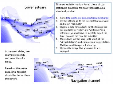
Lower estuary
- Time series information for all these virtual
stations is available, from all forecasts, as a
standard product - Go to http//rdfs.stccmop.org/forecast/schannel
- On the left bar, go to the forecast that you
want, and select Products - Choose a date ( if products for the forecast are
not available for today, use yesterday as a
reference you will have to mentally adjust the
time, because the tidal day is 24.8h) - Move down ion the page, until you find the
virtual stations, and choose your target
station. Multiple small images will show up. - Click on the image that you want to see enlarged.
In the next slides, see examples (salinity and
velocities) for eleu1. Based on the vessel data,
one forecast should be better than the others.
Navigation channel
2
Forecast schannel all times PST
Note that each model may have a slightly
different depth at the station, because of
different grid discretization
3
Forecast nchannel all times PST
Note that each model may have a slightly
different depth at the station, because of
different grid discretization
4
Forecast db16 all times PST
Note that each model may have a slightly
different depth at the station, because of
different grid discretization
5
Forecast schannel all times PST
Ignore the bottom velocity (in green) thats and
artifact of processing.
6
Forecast schannel all times PST
Ignore the bottom velocity (in green) thats and
artifact of processing.
7
Forecast db16 all times PST
Ignore the bottom velocity (in green) thats and
artifact of processing.
Recommended
CrystalGraphics Presentations


