Where is GLASS in GEWEX - PowerPoint PPT Presentation
Title:
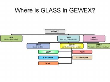
Where is GLASS in GEWEX
Description:
Model Performance Before and After Multi-Criteria Calibration. Before Calibration ... are in good agreement (e.g., the mid-Atlantic coast), but in others (e.g., New ... – PowerPoint PPT presentation
Number of Views:34
Avg rating:3.0/5.0
Title: Where is GLASS in GEWEX
1
Where is GLASS in GEWEX?
2
GLASSGEWEX Global Land-Atmosphere System Study
3
Proposal for a PILPS Experiment in semi-arid
sites
L. A. Bastidas
B. Nijssen, H. Gupta, W. Emmerich, and E. Small
Photo National Geographic
4
Split sample tests
AZ
AZ to NM
- New Mexico sites
- Sevilleta
- Arizona sites
- Lucky Hills
- Kendall
- Tucson
5
Arizona Sites
6
New Mexico Sites
Larrea tridentada Creosotebush
Bouteloua eriopoda Black Grama
1 m
7
Model Performance Before and After Multi-Criteria
Calibration
Energy Partition?
Sw ?
Before Calibration
8
How much improvement is possible ?
20 50
20 50
30
Estimated using Neural Networks
9
Science Questions
- What is the ability of the models to reproduce
the water, energy, and carbon exchanges in
semi-arid environments? - Are the current (usually single) representations
of semi-arid lands in the models enough to
reproduce the different environments that exist
in those areas? - Does model calibration reduce the among-model
range in the model simulations? - How much influence does the model
parameterization have on the parameter
estimations of physically meaningful
parameters? - Do current carbon representations, developed for
forests, properly reproduce carbon exchanges over
vegetated arid lands?
10
Timeline for PILPS 2(g)
- October 2002
- Submission of experimental protocol
- January 2003
- Distribution of forcing data to the participants
- February 2003
- Workshop for training of participants in the use
of the multi-criteria procedures - April 2003
- Deadline for submission of results
- July 2003
- Workshop for analysis of preliminary results.
11
The Second Global Soil Wetness Project (GSWP-2)
12
Goals
- Produce state-of-the-art global data sets of soil
moisture, surface fluxes, and related hydrologic
quantities (1986-1995). - Develop and test in situ and remote sensing
validation, calibration, and assimilation
techniques over land. - Provide a large-scale validation and quality
check of the ISLSCP Initiative II data sets. - Compare LSSs, and conduct sensitivity analyses of
specific parameterizations.
13
Implementation
- Input data access
- DODS server via the internet
- Magnetic or optical media (if necessary)
The model output will go to the Inter-Comparison
Center (ICC) in Japan for consistency checks and
preliminary analysis. Output data from base runs
and sensitivity studies will also be available
for further analysis and validation.
14
- Running the models
- Start from 1st July, 1982
- Jul 1982 Jun 1983 looping for spin up of soil
moisture - Jun 1983 Dec1985 for convergence to realistic
land climate - Jan 1986 Dec1995 for 10 year baseline run
(daily output) - Rerun last year with 3-hour output interval
(IMP) - Jan 1995 Dec 1995 (reduced variable set)
- May specify subset of points for full 10-year
histories at 3-hour output.
15
Multi-Model Analysis
A major product of GSWP2 will be a multi-model
land surface analysis for the ISLSCP II period.
This will be a land surface analog to the
atmospheric reanalyses. There will be a
climatological annual cycle data set, and a
larger data set for the entire series. Compiling
the results of multiple LSSs to produce a single
analysis will provide a model-independent result.
Of particular value, uncertainty estimates can be
put on
all of the fields, based on inter-model spread.
Additional uncertainties regarding forcing data
can be quantified, based on the results of the
sensitivity studies.
Example of the multi-model mean (inset) and
spread in evapotranspiration over North America
during one decad from GSWP1. Over some regions
the models are in good agreement (e.g., the
mid-Atlantic coast), but in others (e.g., New
England) the spread among models exceeds the mean
of the models (color scale is the same for both
plots).
16
Validation I
- There will be three main modes of in situ
validation of participating LSSs - Field campaigns The ISLSCP2/GSWP2 period
overlaps a number of relevant field campaigns,
which can provide validation data. Comparison of
measured meteorological variables with the
reanalysis-based forcing data will also provide a
validation of those products.
2. Observational networks and long-term
monitoring There are also long-term monitoring
networks of soil moisture, radiative and
turbulent fluxes that can provide local or
regional validation for LSSs.
17
Validation II
- There will be three main modes of in situ
validation of participating LSSs - Streamflow Runoff fluxes from LSSs will be
routed with a common river model to compare with
streamflow measurements across a large portion of
the globe. This analysis can also uncover
problems in the forcing data at basin scales.
Also large basin comparison of water storage
change with observed ?V?q Runoff.
Validation data will be converted to the ALMA
data convention to aid in comparison with LSS
output, and to make it readily available for
other uses within GLASS and the broader land
surface modeling community.
18
Conclusions
- GLASS has modeling infrastructure, and GLASS
programs have timelines NAME may leverage off
them where there is mutual interest benefit. - PILPS-2(g) may be leveraged by NAME, and
findings/improvements to LSSs that are also
participating in NAME (GCMs or MMs) can feedback
to the NAME modeling team. NAME should be sure
these LSSs are involved in PILPS-2(g). - GLASS open to input and new ideas for land
surface modeling initiatives.


