The RecordBreaking 910 December 1995 - PowerPoint PPT Presentation
1 / 1
Title:
The RecordBreaking 910 December 1995
Description:
This study explores the synoptic situation and mesoscale processes which led to ... The synoptic and mesoscale situation over Lake Erie and Western New York created ... – PowerPoint PPT presentation
Number of Views:40
Avg rating:3.0/5.0
Title: The RecordBreaking 910 December 1995
1
The Record-Breaking 9-10 December
1995 Lake-Effect Snowstorm A Case Study
Holly A. AndersonSpring 2007 Synoptic
IIFlorida State University
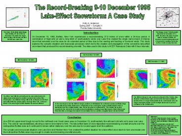
Introduction On December 10, 1995, Buffalo, New
York experienced a record-breaking 37.9 inches of
snow within a 24-hour period. A combination of
frigid artic air and a long fetch of
southwesterly winds over Lake Erie created the
single narrow band of intense snow that remained
over the area for an extended period of time due
to the veering and backing of low-level winds.
This study explores the synoptic situation and
mesoscale processes which led to the creation and
propagation of the convective lake-effect snow
band that produced this record-breaking snowfall.
The data used in this study is NCEP Reanalysis
Data with 6 hour intervals.
This image shows Total Snowfall Amounts for
December 9-11, 1995. Because the band of snow was
so narrow, Buffalo, NY received record-breaking
amounts of snow while locations just miles north
or south received far less.
This Base Reflectivity radar image from Buffalo,
NY at 1418Z on December 10 shows the single band
of lake-effect snow oriented SW/NE over Lake Erie.
12Z December 10 1995
00Z December 10 1995
00Z December 11 1995
The MSLP and 500 mb plot (left) and the
associated wind plot (right) show a low pressure
system centered just north of the Great Lakes. As
a 500 mb trough lifts to the northeast, a cold
front associated with the system passes through
New York. Low-level winds in the area begin to
back towards the west-southwest.
The 500 mb trough is now centered southeast of
the Hudson Bay. Because surface winds have veered
to the west and northwest and therefore no longer
blow parallel to the snow bands axis, the single
snow band breaks up into multiple bands and is
pushed southwest of the Buffalo area.
As the low deepens and the 500 mb trough
continues to lift towards the northeast, cyclonic
vorticity brings in cold artic air and lower
thicknesses. Wind barbs in the Great Lakes region
indicate that the fetch is maximized over the
relatively warm Lake Erie as the wind is
southwesterly. This creates the perfect scenario
for the cold air to be moistened and
destabilized, creating convective bands of
lake-effect snow. Wind direction encourages the
bands to consolidate into one narrow, elongated
band oriented SW/NE.
Conclusion As a 500 mb upper-level trough moved
to the northeast over Great Lakes area on
December 10, southwesterly flow allowed cold
artic air to pass over Lake Erie. The cold air
was destabilized, allowing a narrow snow band to
form. This lake-effect band of snow deposited
record-breaking snowfall amounts over the
metropolitan Buffalo area as it continued to
remain rather stationary over the area due to low
and upper level flow patterns. The synoptic and
mesoscale situation over Lake Erie and Western
New York created the perfect situation for a
lake-effect snow storm to form and reside over
the metropolitan Buffalo area long enough to
create record-breaking snowfall amounts.
- References
- The Use of High Resolution Hourly Forecast
Soundings for the Prediction of Lake Effect Snow,
Thomas A. Niziol and Edward A. Mahoney, NWS,
Buffalo, NY - A RECORD-BREAKING LAKE EFFECT SNOWSTORM IN
BUFFALO, NEW YORK ON 10 DEC 1995 A CASE STUDY,
Joby Hilliker, The Pennsylvania State University,
1996 - NCEP North American Regional Reanalysis
- Atmospheric Soundings, University of Wyoming
- Irv Watson, NWS, Tallahassee, FL


![[PDF READ] Free A Wedding in December: A Novel PowerPoint PPT Presentation](https://s3.amazonaws.com/images.powershow.com/10046158.th0.jpg?_=20240603066)


![[PDF] DOWNLOAD NASB, Holy Bible, XL Edition, Leathersoft, Brown, 1995 Text, PowerPoint PPT Presentation](https://s3.amazonaws.com/images.powershow.com/10050095.th0.jpg?_=20240607092)


