
A Webbased system for modeling multiscale earthquake processes - PowerPoint PPT Presentation
1 / 19
Title:
A Webbased system for modeling multiscale earthquake processes
Description:
Ground-based sensor data (GPS, seismicity) Simulation data ... InSAR and Seismicity Anomalies. Summary. Prototype portal and database have been developed. ... – PowerPoint PPT presentation
Number of Views:77
Avg rating:3.0/5.0
Title: A Webbased system for modeling multiscale earthquake processes
1
A Web-based system for modeling multi-scale
earthquake processes
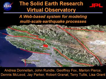
The Solid Earth Research Virtual Observatory
Andrea Donnellan, John Rundle, Geoffrey Fox,
Marlon Pierce, Dennis McLeod, Jay Parker, Robert
Granat, Terry Tullis, Lisa Grant
2
Objectives
- IT approaches Integrate multiple scales into
computer simulations. - Web services Simplified access to data,
simulation codes, and flow between simulations of
varying types.
3
Solid Earth Research Virtual Observatory (iSERVO)
- Web-services (portal) based Problem Solving
Environment (PSE) - Couples data with simulation, pattern recognition
software, and visualization software - Enable investigators to seamlessly merge multiple
data sets and models, and create new queries. - Data
- Spaced-based observational data
- Ground-based sensor data (GPS, seismicity)
- Simulation data
- Published/historical fault measurements
- Analysis Software
- Earthquake fault
- Lithospheric modeling
- Pattern recognition software
4
Philosophy
- Store simulated and observed data
- Archive simulation data with original simulation
code and analysis tools - Access heterogeneous distributed data through
cooperative federated databases - Couple distributed data sources, applications,
and hardware resources through an XML-based Web
Services framework. - Users access the services (and thus distributed
resources) through Web browser-based Problem
Solving Environment clients. - The Web services approach defines standard,
programming language-independent application
programming interfaces, so non-browser client
applications may also be built.
5
SERVOGrid Basics
- Under development in collaboration with
researchers at JPL, UC-Davis, USC, and Brown
University. - Geoscientists develop simulation codes, analysis
and visualization tools. - We need a way to bind distributed codes, tools,
and data sets. - We need a way to deliver it to a larger audience
- Instead of downloading and installing the code,
use it as a remote service.
6
SERVOGrid Application Descriptions
- Codes range from simple rough estimate codes to
parallel, high performance applications. - Disloc handles multiple arbitrarily dipping
dislocations (faults) in an elastic half-space. - Simplex inverts surface geodetic displacements
for fault parameters using simulated annealing
downhill residual minimization. - GeoFEST Three-dimensional viscoelastic finite
element model for calculating nodal displacements
and tractions. Allows for realistic fault
geometry and characteristics, material
properties, and body forces. - Virtual California Program to simulate
interactions between vertical strike-slip faults
using an elastic layer over a viscoelastic
half-space - RDAHMM Time series analysis program based on
Hidden Markov Modeling. Produces feature vectors
and probabilities for transitioning from one
class to another. - PARK Boundary element program to calculate fault
slip velocity history based on fault frictional
properties.a model for unstable slip on a single
earthquake fault. - Preprocessors, mesh generators
- Visualization tools RIVA, GMT
7
Web Services
- Web services are the fundamental pieces of
distributed Service Oriented Architectures. - We should define lots of useful services that are
remotely available - Archival data access services supporting queries,
real time sensor access, and mesh generation all
seem to be popular choices. - Web services have two important parts
- Distributed services
- Client applications
- These two pieces are decoupled one can build
clients to remote services without caring about
the programming language implementation of the
remote service. - Java, C, Python
8
Web Services, Continued
- Clients can be built in any number of styles
- We build portal clients ubiquitous, can combine
- One can build fancier GUI client applications.
- You can even embed Web service client stubs
(library routines) in your application code, so
that your code can make direct calls to remote
data sources, etc. - Regardless of the client one builds, the services
are the same in all cases - my portal and your application code may each use
the same service to talk to the same database. - So we need to concentrate on services and let
clients bloom as they may - Client applications (portals, GUIs, etc.) will
have a much shorter lifecycle than service
interface definitions, if we do our job
correctly. - Client applications that are locked into
particular services, use proprietary data formats
and wire protocols, etc., are at risk.
9
iSERVO Web Services
- Job Submission supports remote batch and shell
invocations - Used to execute simulation codes (VC suite,
GeoFEST, etc.), mesh generation (Akira/Apollo)
and visualization packages (RIVA, GMT). - File management
- Uploading, downloading, backend crossloading
(i.e. move files between remote servers) - Remote copies, renames, etc.
- Job monitoring
- Apache Ant-based remote service orchestration
- For coupling related sequences of remote actions,
such as RIVA movie generation. - Database services support SQL queries
- Data services support interactions with
XML-based fault and surface observation data. - For simulation generated faults (i.e. from
Simplex) - XML data model being adopted for common formats
with translation services to legacy formats. - Migrating to Geography Markup Language (GML)
descriptions.
10
SERVO Grid
Solid Earth Research Virtual Observatory using
grid technologies and high-end computers
11
Problem Solving Environment
High-level architecture of planned system showing
grids, portals, and grid computing environments.
12
(No Transcript)
13
(No Transcript)
14
(No Transcript)
15
(No Transcript)
16
GeoFEST Northridge Earthquake Deformation
17
Virtual California 1000 Years of Simulated
Earthquakes
18
Pattern RecognitionInSAR and Seismicity
Anomalies
19
Summary
- Prototype portal and database have been
developed. - SERVO is being used to carry out system level
science with the initial focus being on southern
California. - More info http//quakesim.jpl.nasa.gov
Recommended
CrystalGraphics Presentations


![???? ?? Multiscale simulation for process development [Ch. 2] in Computational multiscale modeling of fluids and solids by M.O. Steinhauser PowerPoint PPT Presentation](https://s3.amazonaws.com/images.powershow.com/7058493.th0.jpg?_=201508190512)


