Nevado del Ruiz - PowerPoint PPT Presentation
1 / 20
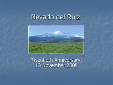
Title: Nevado del Ruiz
1
Nevado del Ruiz
- Twentieth Anniversary 13 November
2005
2
- Location and Physical Setting
3
Location and Physical Setting
- Located North-West of Bogata.
- Located in Columbia Andes.
- East-Cordillera Oriental-Formed From Compressive
ForcesLimestone, Shale, Sandstone. - West-Cordillera Occidental-Formed By
Accreting--Ocean Sediment and Basalt. - Central CordilleraFormed by Subducted Nazca
Plate - Tectonically Active Area.
- Nazca Plate Is Subducted 5 cm/year.
- Northwest Is the Intersection of the Caribbean,
Cocos, and Nazca Plates.
4
Nevado del Ruiz
- Stratovolcano
- Layered Volcano With Alternating Layers of
Pyroclastic Deposits and Lava. - Silica Rich Magma.
- Elevation 5,400 Meters.
- Perennially Snow and Ice Covered.
- Ice Thickness 10 to 30 Meters.
- Area Extent 19 Square Kilometers.
5
Nevado del Ruiz
- Slope
- Above 4,000 Meters 20 to 30 Percent.
- Geologically Recent Age Deposits.
- Below 4,000 Meters 10 Percent.
- Unknown Age, but Much Older Deposits.
- Symmetrically Extend to the River Plains in East
and West. - River Courses Draining the Volcano Have Steep
V-Shaped Ravines. - In the East the Guali, Azufrado Lagunillas, and
Rico Rivers drain to the Magdalena River. - In the West the Claro, Molinos, and Chinchina
Rivers drain to the Cauca River.
6
(No Transcript)
7
Volcanic Activity
- Began Showing Volcanic Activity in November 1984.
8
Monitoring Volcanic Activity
- No Money or Much Support From Columbia
Government. - Monitoring Came Largely From a Corporation of
Coffee Growers and From a Hydroelectric Company. - Office Space in Manizales.
- Scientists
- UN Disaster Relief Office and USGS Gave 3
Seismographs, But No Technical Assistance. - Swiss Donated 3 More, and Taught Scientists How
to Use Them.
9
Monitoring Volcanic Activity
- Lots of Infighting Between Local Monitoring
Office and Columbias National Institute of
Geology and Mines (INGEOMINAS). - The Seismic Readings Were Sent To INGEOMINAS in
Bogata. - Really Needed Equipment That Would Relay the Data
Directly to The Office in Manizales. - September 1985, Seismic Activity Increased Until
There was a Steam Explosion on September 11, 1985.
10
Volcanic Eruption
- November 13, 1985.
- 305 pm Steam Producing Eruption.
- 910 pm Reportedly 2 Explosions Followed By
Pyroclastic Flows. - 937 Strongest Eruption Occurred.
- Plume of Gas, Pyroclastics 1,000 M Above the
Mountain. - Top of Volcano Covered By 8 M of Pyroclastic
Material.
11
Lahars
- Pyroclastic Surges Eroded and Melted about 10 of
Ice Cover. - Water Mixed With Rock Debris and Quickly Moved to
the Village of Chinchina, 15 Miles From the
Summit. - Most Did Not Evacuate.
- 1,000 Dead
- Armero-East
- Two Channels, the Azufrado and the Lagunillas
River. - Killed 23,000 People.
12
Armero Lahars
- Three PulsesSometime After 11 PM.
- First Pulse Was Mainly Water That Was Displaced
From a Lake Upstream. - Second Pulse Destroyed Most of Town.
- Hot Pyroclastic Material Mixed With Soil, Water,
and debris. - Ranged From 2 To 5 Meters.
- Third Pulse Was Slower in Velocity and Pushed
People and Debris Further Downstream. - Pulses Caused By Damming of Rivers.
13
Social Impacts
- Main Impacts to the East
- Estimated Losses 218 Million Dollars.
- Everyone in the Valley Knew Someone Who Was
Killed. - Communications Such as Phone Lines, Road
Networks, and Bridges Destroyed. - 10,000 Persons Were Left Homeless.
- Two Hospitals Were Destroyed and 50 Schools.
- Experienced Workers Were Lost.
- Armero Served as Regional Center for Financial
Services, Farm Equipment, and Had a Junior
College.
14
Prevention of Risk Prior To Eruption
- INGEOMINAS Created a Risk Map of the Area.
- First Draft Was Done on October 7, 1985.
- Finalized November 10, 1985.
- 100 Chance that Armero Would Be Destroyed.
- Columbian Congress and Some Local Officials Did
Not Believe the Risk Was That Great. - Columbia Civil Defense, Red Cross, and National
Committee of Regional and Local Organizations Did
Believe and Planned Procedures For Evacuating
Places at Risk.
15
(No Transcript)
16
Prevention of Risk Prior To Eruption
- Civil Defense Operations
- Gathered Emergency Supplies.
- Compiled Census Living Near Rivers at Risk.
- Distributed 1,000s of Public Information
Pamphlets. - Uncertain How Many People Got These.
- Uncertain How Well They Understood What a Lahars
Could Do. - Conflicting Messages, The Local Catholic Priest
Urged People to Stay Inside.
17
Prevention of Risk Prior To Eruption
- There Was a Call To Evacuate Armero By the Red
Cross. - People Were Reluctant Because of Thunderstorm.
- May Have Masked Some Noise From Volcano.
- May Have Been Sporadic Power Outages.
- General Uncertainty of Risk.
- Due To Large Number of Deaths, There Is No Way of
Knowing If There Was a Systematic, Large Scale
Effort to Inform the Population.
18
After The Eruption
- Strong Push to Educate Population At Risk If
There Is Another Eruption. - Siren In Each Neighborhood and Flyers Were
Distributed Instructing Population To Evacuate
When Sirens Are Heard. - One Test and One Potential Incident, But Very Few
People Evacuated. - Initial System To Inform Population To Evacuate
Went Through Many Layers of Government, Which
Took Over 3 Hours.
19
International Changes
- Creation of Volcano Disaster Assistance Program
(VDAP). - Countries That Do Not Have the Technical
Equipment Or Expertise to Monitor An Awakening
Volcano Can Request It Through USAID. - Goal Is To Reduce Deaths And Economic Losses.
20
- The End

