Mobile Doppler Radar Observations of a Front during IHOP - PowerPoint PPT Presentation
1 / 20
Title: Mobile Doppler Radar Observations of a Front during IHOP
1
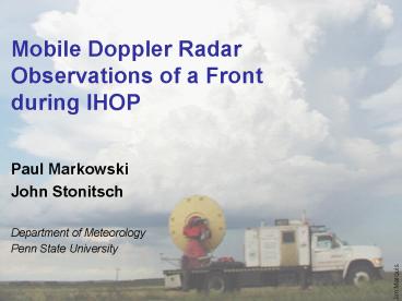
Mobile Doppler Radar Observations of a Front
during IHOP
- Paul Markowski
- John Stonitsch
- Department of Meteorology
- Penn State University
Jim Marquis
2
3 June 2002
- Null case
- Cold front stalled near Turpin, OK, later
retreated as a warm front - Dense cirrus over front
- Convection developed on higher terrain NW of
front - Multiple-Doppler data from 4 mobile radars from
16-23 UTC (DOW2, DOW3, XPOL, SR1)
3
(No Transcript)
4
(No Transcript)
5
Deployment 1 1615-1815 UTC
6
Deployment 1 1615-1815 UTC
4 radars Radial velocity data interpolated to
grid using Barnes (exponential) weight function
with k 0.20 km2 20 x 20 x 1 km
grid 0.1 km grid spacing
Used over-determined dual-Doppler approach and
anelastic mass continuity equation (integrated
upward) analyses every 180 s
7
1615-1815 UTC
v 2 m/s isosurface
10
-10
-10
10
8
1615-1815 UTC
w
z 350 m
vertical motions become increasingly vigorous as
time elapses
10
max w of 3 m/s
w larger on warm side of front
y (km)
rolls?
-10
10
-10
x (km)
3 m s-1
-3 m s-1
9
1615-1815 UTC
z
z 100 m
10
y (km)
-10
10
-10
x (km)
0.015 s-1
-0.006 s-1
10
1658-1735 UTC
11
Deployment 2 1912-2036 UTC
12
Deployment 2 1912-2036 UTC
13
1912-2036 UTC
front still slowly advancing as a cold front
10
wavelike perturbations along frontal zone
y (km)
-10
-10
10
x (km)
14
1912-2036 UTC
w
z 350 m
10
vertical motions become disorganized along the
front toward 2000 UTC (front will begin
retreating toward NW soon after)
boundary layer convection away from the front is
less vigorous than earlier (dense cirrus overcast
likely played a role)
y (km)
-10
10
-10
x (km)
3 m s-1
-3 m s-1
15
1912-2036 UTC
z
z 100 m
vortices have vertical continuity
10
vortices generally weaken with height
advection vs propagation?
y (km)
relationships with w and horizontal convergence?
-10
10
-10
x (km)
0.015 s-1
-0.006 s-1
16
1921 UTC
z
d
z 100 m
z 100 m
10
10
4
4
3
3
y (km)
y (km)
2
2
1
1
-10
-10
10
-10
-10
10
x (km)
x (km)
0.006 s-1
-0.006 s-1
0.015 s-1
-0.006 s-1
17
1921 UTC
z
w
z 350 m
z 100 m
10
10
4
4
3
3
y (km)
y (km)
2
2
1
1
-10
-10
10
-10
10
-10
x (km)
x (km)
3 m s-1
-3 m s-1
0.015 s-1
-0.006 s-1
18
Future Plans
- Combine thermodynamic information (particularly
water vapor data) with the 4D wind analyses
obtained thusfar - Dynamic retrievals
- In situ obs (mobile soundings, aircraft obs,
dropsondes, mobile mesonet) - Indirect obs (mobile radiometers, airborne water
vapor lidar)
19
Questions
- What were the effects of inflections in the
frontal zone on vertical motion, water vapor
mixing ratio, and virtual potential temperature? - How did the baroclinity along the boundary change
as a function of time, and what kinematic
changes, if any, were associated with the
baroclinity changes? - How did horizontal vorticity vary in time along
the boundary, and what were the quantitative
contributions to its tendency from baroclinity,
advection, convergence, and turbulent
dissipation? - Which characteristics of the front and/or
mesoscale environment precluded convection
initiation? - Changes in frontal structure as frontal motion
changed?
20
Acknowledgments
Conrad Ziegler Josh Wurman Mike
Buban Christina Hannon Yvette
Richardson Nettie Arnott Curtis
Alexander numerous other IHOP volunteers Erik
Rasmussen Kevin Knupp Justin Walters NSF
ATM-0130307


